 FAO Map Catalog
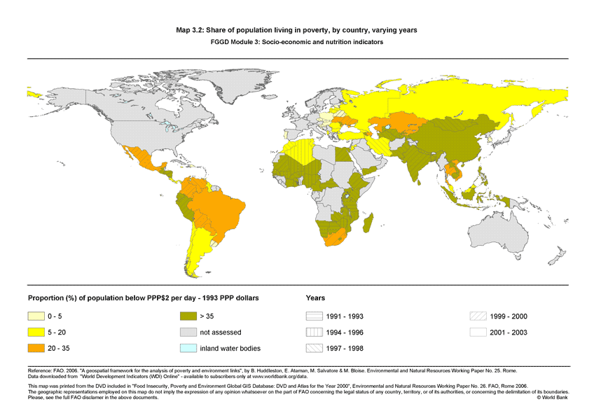
Share of population living in poverty, by country, varying years (FGGD)
The FGGD poverty map is a global vector datalayer at scale 1:5 000 000. The map depicts the differences among countries with respect to the national population estimated to be living in poverty as of the latest year for which data was available in 2005. Data have been compiled by FAO from data reported in World Bank, WDI Online, as of April 2005.
Simple
- Date ( Publication )
- 2007-06-25
- Edition
- 1.0
- Presentation form
- Digital map
- Purpose
- The FGGD Digital Atlas consists of more than 100 global database that allows to analyse food insecurity and poverty in relation to the environment.
- Status
- Completed
Point of contact
FAO - GIS UNIT
-
(
GIS Manager
)
Viale delle Terme di Caracalla, 1
,
Rome
,
00153
,
Italy
- Maintenance and update frequency
- As needed
- Keywords ( Theme )
-
- community development
- social development
- poverty
- low income groups
- Keywords ( Place )
-
- World
- Access constraints
- Copyright
- Use constraints
- Copyright
- Spatial representation type
- Vector
- Metadata language
- eng
- Character set
- UTF8
- Topic category
-
- Society
- Health
N
S
E
W
))
- Supplemental Information
- This dataset is contained in Module 3 "Socio-economics and nutrition indicators" of Food Insecurity, Poverty and Environment Global GIS Database (FGGD) (FAO, 2007).
- Reference system identifier
- GCS_WGS_1984
- Distribution format
-
-
TIFF
(
)
-
TIFF
(
)
- OnLine resource
-
Map3_2.zip
(
WWW:DOWNLOAD-1.0-http--download
)
Share of population living in poverty, by country, varying years
- OnLine resource
-
poverty_14118
(
OGC:WMS-1.1.1-http-get-map
)
poverty_14118
Data quality info
No information provided.
gmd:MD_Metadata
- File identifier
- 4fbe4320-8518-11db-b9b2-000d939bc5d8 XML
- Metadata language
- eng
- Character set
- UTF8
- Date stamp
- 2023-02-02T14:30:31
- Metadata standard name
- ISO 19115:2003/19139
- Metadata standard version
- 1.0
Point of contact
FAO - GIS UNIT
-
Mirella Salvatore
(
Consultant
)
Via delle Terme di Caracalla, 1
,
Rome
,
00153
,
Italy
Overviews

thumbnail
large_thumbnail
Spatial extent
N
S
E
W
Provided by

Associated resources
Not available