 FAO Map Catalog
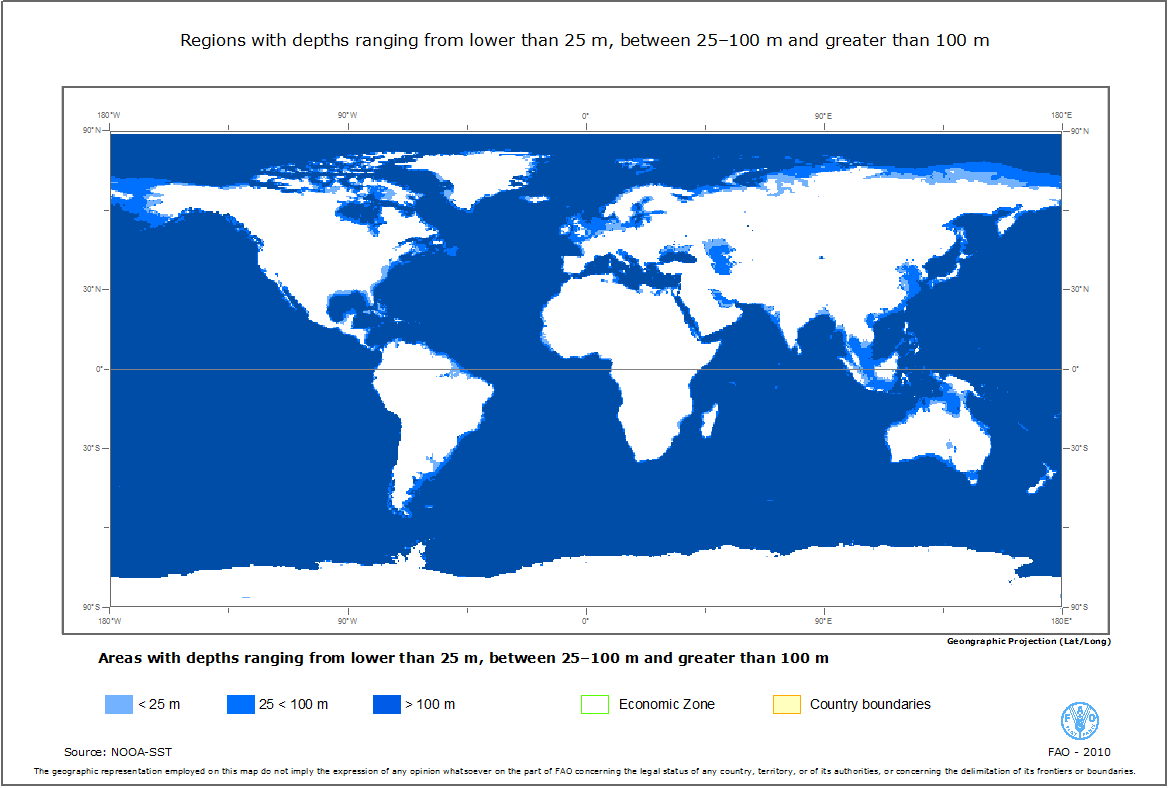
Regions with depths ranging from lower than 25 m, between 25-100 m and greater than 100 m
This dataset includes the regions with sea depths ranging from lower than 25 m, between 25-100 m and greater than 100 m.
Simple
- Date ( Publication )
- 2010-04-13T01:00:00
- Edition
- First
- Presentation form
- Digital map
- Purpose
- The dataset has been used to support a FAO offshore mariculture initiative that aims to provide spatial measures of the status and potential for off-the-coast and offshore mariculture development that are comprehensive of all maritime nations and comparable among them.
- Status
- Completed
Point of contact
Food and Agriculture Organization of the United Nations
-
Jos� Aguilar-Manjarrez
(
Fishery Resources Officer
)
Viale delle Terme di Caracalla
,
Rome
,
00153
,
Italy
Point of contact
Food and Agriculture Organization of the United Nations
-
James McDaid Kapetsky
(
Senior fisheries resources advisor
)
- Maintenance and update frequency
- As needed
- Keywords ( Theme )
-
- sea depth
- Mariculture
- Offshore mariculture
- Keywords ( Place )
-
- World
- Access constraints
- Copyright
- Use constraints
- Copyright
- Spatial representation type
- Vector
- Metadata language
- eng
- Character set
- UTF8
- Topic category
-
- Farming
- Oceans
N
S
E
W
))
- Supplemental Information
- This dataset supports part of a review on "Spatial analysis for the sustainable development of off-the-coast and offshore aquaculture from a global perspective" to support an FAO offshore mariculture initiative. The initiative attempts to collect global information on the potential for mariculture development (off-the-coast and offshore) considering technical, biological, spatial, environmental, socio-economic, legal and policy issues and to identify major opportunities and challenges to act upon at the relevant level by FAO, its Member States and other stakeholders for the industry to expand sustainably.
- Reference system identifier
- WGS 1984
- Topology level
- Geometry only
- Geometric object type
- Complex
- Units of distribution
- Arc/GIS shapefile
- Transfer size
- 717KB
- OnLine resource
-
Current_Speeds_1_10_cms.zip
(
WWW:DOWNLOAD-1.0-http--download
)
Regions with depths ranging from lower than 25 m, between 25-100 m and greater than 100 m
- OnLine resource
-
Speed1_10.jpg
(
WWW:DOWNLOAD-1.0-http--download
)
Regions with depths ranging from lower than 25 m, between 25-100 m and greater than 100 m - JPG image
- Protocol
- OGC:WMS-1.1.1-http-get-map
- Hierarchy level
- Dataset
gmd:MD_Metadata
- File identifier
- 44752cb4-d5f9-4a61-a8ce-eab9bb6ab8f9 XML
- Metadata language
- eng
- Character set
- UTF8
- Date stamp
- 2012-11-30T20:18:21
- Metadata standard name
- ISO 19115:2003/19139
- Metadata standard version
- 1.0
Overviews

thumbnail
large_thumbnail
Spatial extent
N
S
E
W
Provided by

Associated resources
Not available