 FAO Map Catalog
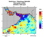
Chlorophyll Climatology over the Persian/Oman Gulfs - 1998-2009, April 2004 Anomaly
Over the Persian Gulf and Oman Sea, climatology of the chlorophyll-a concentration for case 1 water (expressed in mg/m3). The climatology is based on the GlobColour (http://www.globcolour.info) products obtained by the merging of MERIS MODIS and SeaWIFS data available during the period 1998-2009. The "April 2004 Anomaly" product represents for each pixel, the difference between the chlorophyll-a concentration product by merging for each of the 12 years the considered month (April) and the chlorophyll-a concentration observed in April 2004. The difference is expressed as a percentage of change "(April 2004 �?? April 1998-2009) / April 1998-2009".
The spatial resolution of the product is about 4km.
The product has been designed and produced by ACRI-ST INFOCEAN-DESK environment monitoring service from EU FP7 & ESA MyOcean GlobColour Products, ESA ENVISAT MERIS data, NASA MODIS and SeaWiFS data.
The GlobColour project has been initiated and funded by the ESA Data User Element Programme to develop a satellite based ocean colour data service to support global carbon-cycle research. The GlobColour project has largely benefited from NASA contributions, including the availability of the MODIS and SeaWiFS products; the in situ data base of radiometric and phytoplankton pigment data, and other oceanographic and atmospheric data: the SeaWiFS Bio-optical Archive and Storage System - SeaBASS (Werdell and Bailey, 2002). The global merged chlorophyll-a concentration for case 1 water is obtained by the merging of MERIS, MODIS and SeaWiFS data using an advanced retrieval based on fitting an in-water bio-optical model to the merged set of observed normalised water-leaving radiances (nLw?s). This technique is termed GSM because it originates from the Garver et al. (1997) bio-optical model (Maritorena and Siegel, 2005). More details are available at http://www.globcolour.info/CDR_Docs/GlobCOLOUR_PUG.pdf.
Simple
- Date ( Publication )
- 2010-04-13T16:48:00
- Edition
- First
- Presentation form
- Digital map
- Purpose
- The data aims to support the application of remote sensing by potential users active in off-the-coast and offshore aquaculture development
- Status
- Completed
- Maintenance and update frequency
- As needed
- Keywords ( Theme )
-
- Aquaculture
- Mariculture
- Chlorophyll
- Remote sensing
- Offshore mariculture
- World
- Keywords ( Place )
-
- Persian Gulf
- Keywords ( Place )
-
- Oman Sea
- Access constraints
- Copyright
- Use constraints
- Copyright
- Spatial representation type
- Grid
- Metadata language
- eng
- Character set
- UTF8
- Topic category
-
- Oceans
))
- Supplemental Information
- These data support part of a review on Remote Sensing for the Sustainable Development of Marine Aquaculture Off-the-Coast and Offshore to support an FAO offshore mariculture initiative. The initiative attempts to collect global information on the potential for mariculture development (off-the-coast and offshore) considering technical, biological, spatial, environmental, socio-economic, legal and policy issues and to identify major opportunities and challenges to act upon at the relevant level by FAO, its Member States and other stakeholders for the industry to expand sustainably.
- Reference system identifier
- WGS 1984
- Units of distribution
- Tiff format
- Transfer size
- 1.5 MB
- OnLine resource
-
46d89E-70d99E-10d88N-30d15N_merged_GSM_CHL1_1998-2009_04_anomaly_2004.zip
(
WWW:DOWNLOAD-1.0-http--download
)
Chlorophyll Climatology over the Persian/Oman Gulfs - 1998-2009, April 2004 Anomaly
- OnLine resource
- http://www.fao.org:80/geonetwork/srv/en/resources.get?id=37313&fname=&access=private ( WWW:DOWNLOAD-1.0-http--download )
- Protocol
- OGC:WMS-1.1.1-http-get-map
- Hierarchy level
- Dataset
- Statement
- The GlobColour products have undergone an extensive validation based on a validation protocol derived from the SIMBIOS protocol. The GlobColour products have been derived with the GSM model and algorithm, developed by ICESS (Maritorena S. and D.A. Siegel. 2005).
gmd:MD_Metadata
- File identifier
- 3113395a-0c3c-4756-8625-3b0737dd252c XML
- Metadata language
- eng
- Character set
- UTF8
- Date stamp
- 2010-05-20T15:10:55
- Metadata standard name
- ISO 19115:2003/19139
- Metadata standard version
- 1.0
Overviews

Spatial extent
Provided by
