 FAO Map Catalog
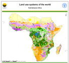
Land Use Systems of the World - Sub-Saharan Africa (Beta version)
Beta version of a thematic grid of Land Use Systems (LUS) and its attributes for Sub-Saharan Africa with a spatial resolution of 5 arc minutes or 0.083333 decimal degrees. This dataset, presented as beta version, is developed in the framework of the LADA project (Land degradation Assessment in Drylands) by the Land Tenure and Management Unit of the Food and Agriculture Organization of the United Nations and is copyright of FAO/UNEP GEF. The LUS map implementation is based on a innovative methodology combining more than 10 global datasets.
Due to the map generation method, the quality of the map can never be uniform. The overall quality of the map depends heavily on the individual quality of the data for the different countries.
Simple
- Date ( Creation )
- 2008-04-09
- Edition
- Beta version
- Presentation form
- Digital map
- Purpose
- The map and its database are furnished as beta version to allow users to test its functionalities. The general purpose of the map is to describe the Land Use Systems of the world.
- Status
- On going
- Maintenance and update frequency
- As needed
- Keywords ( Theme )
-
- land use
- land use systems
- Tag_LUS
- Tag_land
- Keywords ( Place )
-
- South of Sahara
- Access constraints
- Copyright
- Spatial representation type
- Grid
- Denominator
- 5000000
- Metadata language
- eng
- Character set
- UTF8
- Topic category
-
- Environment
- Begin date
- 1998-01-01T14:35:00
- End date
- 2008-04-08T14:35:00
))
- Supplemental Information
- The map shows the Land Use systems units on a raster with a resolution of 5 minutes, while its attributes table includes: land use systems, ecosystems, crops, crop groups, irrigated areas, thermal climate, LGP, soils, slope, population density and infant mortality rate.
- Reference system identifier
- WGS 1984
- Number of dimensions
- 2
- Dimension name
- Row
- Dimension size
- 896
- Resolution
- 0.08333 Decimal Degree,
- Dimension name
- Column
- Dimension size
- 1174
- Resolution
- 0.08333 Decimal Degree,
- Dimension name
- Vertical
- Cell geometry
- Area
- Transformation parameter availability
- No
- Protocol
- WWW:LINK-1.0-http--link
- OnLine resource
-
lus_ssa.zip
(
WWW:DOWNLOAD-1.0-http--download
)
Land Use Systems Database - ESRI GRID with attributes
- OnLine resource
-
lus_ssa_bildb.zip
(
WWW:DOWNLOAD-1.0-http--download
)
Land Use Systems Database - Raster (.BIL) with Access database
- OnLine resource
-
geonetwork:lus_ssa_31667
(
OGC:WMS-1.1.1-http-get-map
)
Land Use Systems of the World - Sub-Saharan Africa (Beta version)
- Hierarchy level
- Dataset
- Statement
- The map and its database are furnished as beta version to allow users to test its functionalities.
gmd:MD_Metadata
- File identifier
- 130218c0-0614-11dd-af4e-0017f293bd28 XML
- Metadata language
- eng
- Character set
- UTF8
- Date stamp
- 2019-11-22T10:37:31
- Metadata standard name
- ISO 19115:2003/19139
- Metadata standard version
- 1.0
Overviews

Spatial extent
Provided by
