 FAO Map Catalog
Awash River Basin: Wereda covered by pilot survey
Wereda (administrative units) covered by pilot survey of irrigation schemes for the project GCP/GLO/207/ITA
Simple
- Date ( Publication )
- 2008-01-01T00:00:00
- Edition
- Version 1
- Presentation form
- Digital map
- Purpose
- Assessment of agricultural water requirements.
- Status
- Completed
Distributor
FAO Ethiopia
-
Yibeltal Tiruneh
(
Irrigation Officer
)
FAOR P.O. Box 5536
,
Addis Ababa
,
Ethiopia
- Maintenance and update frequency
- As needed
- Keywords ( Theme )
-
- watersheds
- hydrology
- irrigation
- Tag_AQUASTAT
- Keywords ( Place )
-
- Ethiopia
- Access constraints
- Restricted
- Spatial representation type
- Vector
- Denominator
- 500000
- Metadata language
- eng
- Character set
- UTF8
- Topic category
-
- Inland waters
N
S
E
W
))
- Supplemental Information
- Data downladable upon permission given by owner (Ethiopian Ministry of Water and Energy). Please contact distributor or points of contact.
- Reference system identifier
- Adindan_UTM_Zone_37N
- Topology level
- Geometry only
- Geometric object type
- Complex
- Units of distribution
- shapefile
- OnLine resource
-
Agricultural Water Management Information System of Ethiopia
(
WWW:LINK-1.0-http--link
)
Information
- Protocol
- WWW:LINK-1.0-http--link
- Name
- DVD
- Hierarchy level
- Dataset
gmd:MD_Metadata
- File identifier
- 103c7a85-37b2-45a8-ae0a-20760ad548a8 XML
- Metadata language
- eng
- Character set
- UTF8
- Date stamp
- 2020-01-31T10:55:20
- Metadata standard name
- ISO 19115:2003/19139
- Metadata standard version
- 1.0
Point of contact
FAO-UN Land and Water Division
-
AQUASTAT
Viale delle Terme di Caracalla
,
Rome
,
00153
,
Italy
Overviews
thumbnail
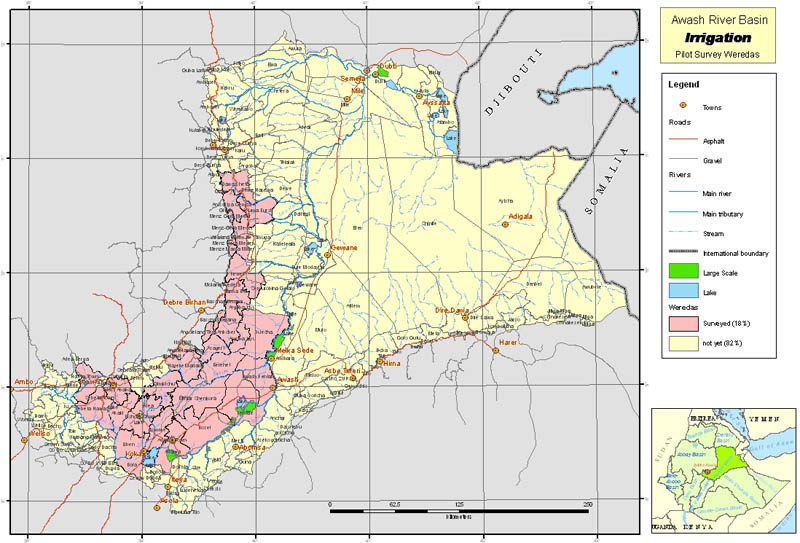
large_thumbnail
Spatial extent
N
S
E
W
Provided by

Associated resources
Not available