 FAO Map Catalog
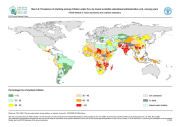
Prevalence of stunting among children under five, by lowest available subnational administrative unit, varying years (FGGD)
Simple
- Date ( Publication )
- 2007-06-25
- Edition
- 1.0
- Presentation form
- Digital map
- Purpose
- The FGGD Digital Atlas consists of more than 100 global database that allows to analyse food insecurity and poverty in relation to the environment.
- Status
- Completed
- Maintenance and update frequency
- As needed
- Keywords ( Theme )
-
- malnutrition
- undernutrition
- poverty
- social development
- community development
- health
- Keywords ( Place )
-
- World
- Access constraints
- Copyright
- Use constraints
- Copyright
- Spatial representation type
- Grid
- Metadata language
- eng
- Character set
- UTF8
- Topic category
-
- Society
- Health
))
- Supplemental Information
- This dataset is contained in Module 3 "Socio-economics and nutrition indicators" of Food Insecurity, Poverty and Environment Global GIS Database (FGGD) (FAO, 2007).
- Reference system identifier
- GCS_WGS_1984
- Number of dimensions
- 2
- Dimension name
- Row
- Dimension size
- 2160
- Resolution
- 0.08333333 ,
- Dimension name
- Column
- Dimension size
- 4320
- Resolution
- 0.08333333 ,
- Cell geometry
- Area
- Transformation parameter availability
- Yes
- Distribution format
-
-
TIFF
(
)
-
TIFF
(
)
- OnLine resource
-
Map3_6.zip
(
WWW:DOWNLOAD-1.0-http--download
)
Prevalence of stunting among children under five, by lowest available subnational administrative unit, varying years
- OnLine resource
-
Chronic Undernutrition among Children - An Indicator of Poverty
(
WWW:LINK-1.0-http--link
)
Chronic Undernutrition among Children - An Indicator of Poverty
- OnLine resource
-
geonetwork:stunting_14123
(
OGC:WMS-1.1.1-http-get-map
)
Prevalence of stunting among children under five
Data quality info
gmd:MD_Metadata
- File identifier
- 0dc30f20-851b-11db-b9b2-000d939bc5d8 XML
- Metadata language
- eng
- Character set
- UTF8
- Date stamp
- 2023-01-19T12:25:28
- Metadata standard name
- ISO 19115:2003/19139
- Metadata standard version
- 1.0
Overviews

Spatial extent
Provided by
