 FAO Map Catalog
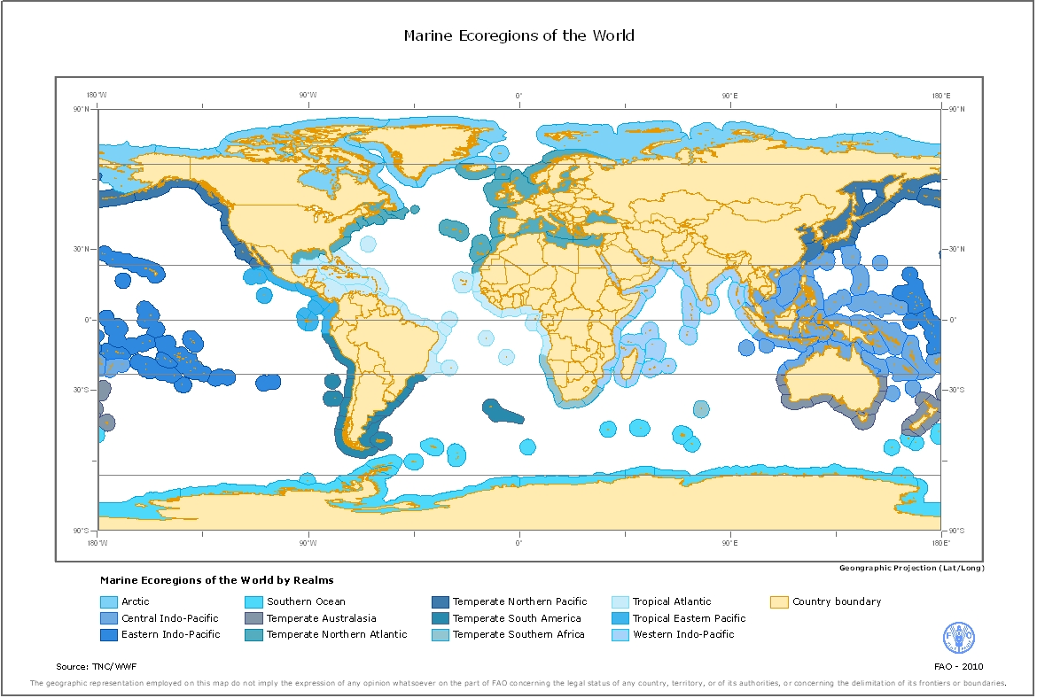
Marine Ecoregions of the World (MEOW)
MEOW is a biogeographic classification of the world's coasts and shelves. It is the first ever comprehensive marine classification system with clearly defined boundaries and definitions and was developed to closely link to existing regional systems. The ecoregions nest within the broader biogeographic tiers of Realms and Provinces.
MEOW represents broad-scale patterns of species and communities in the ocean, and was designed as a tool for planning conservation across a range of scales and assessing conservation efforts and gaps worldwide. The current system focuses on coast and shelf areas (as this is where the majority of human activity and conservation action is focused) and does not consider realms in pelagic or deep benthic environment. It is hoped that parallel but distinct systems for pelagic and deep benthic biotas will be devised in the near future.
The project was led by The Nature Conservancy (TNC) and the World Wildlife Fund (WWF), with broad input from a working group representing key NGO, academic and intergovernmental conservation partners.
The digital ecoregions layer is available for download as an ArcGIS Shapefile at
http://conserveonline.org/workspaces/ecoregional.shapefile/MEOW/view.html.
Simple
- Date ( Revision )
- 2008-10-07T10:00:00
- Edition
- First
- Presentation form
- Digital map
- Purpose
- The dataset has been used to support a FAO offshore mariculture initiative that aims to provide spatial measures of the status and potential for off-the-coast and offshore mariculture development that are comprehensive of all maritime nations and comparable among them.
- Status
- Completed
- Maintenance and update frequency
- As needed
- Keywords ( Theme )
-
- Aquaculture
- GIS
- Mariculture
- ecoregion
- Keywords ( Place )
-
- World
- Access constraints
- Copyright
- Use constraints
- Copyright
- Other constraints
- This spatial data layer is available for use for valid scientific, conservation, and educational purposes. We ask to cite and credit the Marine Ecoregions data as follows: Spalding MD, Fox HE, Allen GR, Davidson N, Ferda�a ZA, Finlayson M, Halpern BS, Jorge MA, Lombana A, Lourie SA, Martin KD, McManus E, Molnar J, Recchia CA, Robertson J (2007) Marine Ecoregions of the World: a bioregionalization of coast and shelf areas. BioScience 57: 573-583. Any modification of the original map to ecoregion boundaries, units, names, or realm and province classes must be noted and explained alongside the original citation. Notice - For any reuse or distribution, you must make clear to others the license terms of this work. The best way to do this is with a link to this web page: http://creativecommons.org/licenses/by-nc/3.0/
- Spatial representation type
- Vector
- Metadata language
- eng
- Character set
- UTF8
- Topic category
-
- Farming
))
- Supplemental Information
- This dataset supports part of a review on "Spatial analysis for the sustainable development of off-the-coast and offshore aquaculture from a global perspective" to support an FAO offshore mariculture initiative. The initiative attempts to collect global information on the potential for mariculture development (off-the-coast and offshore) considering technical, biological, spatial, environmental, socio-economic, legal and policy issues and to identify major opportunities and challenges to act upon at the relevant level by FAO, its Member States and other stakeholders for the industry to expand sustainably.
- Reference system identifier
- WGS 1984
- Topology level
- Geometry only
- Geometric object type
- Complex
- OnLine resource
-
Download Marine Ecoregions of the World (MEOW) -ArcGIS shapefile
(
WWW:LINK-1.0-http--link
)
Download Marine Ecoregions of the World (MEOW) -ArcGIS shapefile
- OnLine resource
-
Marine Ecoregions of the World - Paper in PDF
(
WWW:LINK-1.0-http--link
)
Marine Ecoregions of the World - Paper in PDF
- Protocol
- OGC:WMS-1.1.1-http-get-map
- Hierarchy level
- Dataset
gmd:MD_Metadata
- File identifier
- 00dfb212-7224-4069-b935-421bc1f30d23 XML
- Metadata language
- eng
- Character set
- UTF8
- Date stamp
- 2010-05-20T16:59:49
- Metadata standard name
- ISO 19115:2003/19139
- Metadata standard version
- 1.0
Overviews
Spatial extent
Provided by
