 FAO Map Catalog
oceans
Type of resources
Available actions
Topics
Keywords
Contact for the resource
Provided by
Years
Formats
Representation types
Update frequencies
status
Scale
-
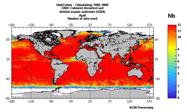
For the Global Ocean, climatology of the chlorophyll-a concentration for case 1 water (expressed in mg/m3). The climatology is based on the GlobColour (http://www.globcolour.info) products obtained by the merging of MERIS MODIS and SeaWIFS data available during the period 1998-2009. The "Number of data" product represents for each pixel, the number of data available when computing the chlorophyll-a concentration product by merging for each of the 12 years the selected month (April). Depending of the location of the pixel, the number of data varies from 0 to 12. The spatial resolution of the product is about 4km. The product has been designed and produced by ACRI-ST INFOCEAN-DESK environment monitoring service from EU FP7 & ESA MyOcean GlobColour Products, ESA ENVISAT MERIS data, NASA MODIS and SeaWiFS data. The GlobColour project has been initiated and funded by the ESA Data User Element Programme to develop a satellite based ocean colour data service to support global carbon-cycle research. The GlobColour project has largely benefited from NASA contributions, including the availability of the MODIS and SeaWiFS products; the in situ data base of radiometric and phytoplankton pigment data, and other oceanographic and atmospheric data: the SeaWiFS Bio-optical Archive and Storage System - SeaBASS (Werdell and Bailey, 2002). The global merged chlorophyll-a concentration for case 1 water is obtained by the merging of MERIS, MODIS and SeaWiFS data using an advanced retrieval based on fitting an in-water bio-optical model to the merged set of observed normalised water-leaving radiances (nLw?s). This technique is termed GSM because it originates from the Garver et al. (1997) bio-optical model (Maritorena and Siegel, 2005). More details are available at http://www.globcolour.info/CDR_Docs/GlobCOLOUR_PUG.pdf.
-

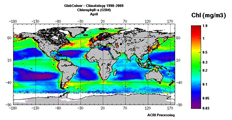
For the Global Ocean, climatology of the chlorophyll-a concentration for case 1 water (expressed in mg/m3). The climatology is based on the GlobColour (http://www.globcolour.info) products obtained by the merging of MERIS MODIS and SeaWIFS data available during the period 1998-2009. The mean value product represents the mean chlorophyll-a concentration obtained by merging for each of the 12 years the selected month (April). The spatial resolution of the product is about 4km. The product has been designed and produced by ACRI-ST INFOCEAN-DESK environment monitoring service from EU FP7 & ESA MyOcean GlobColour Products, ESA ENVISAT MERIS data, NASA MODIS and SeaWiFS data. The GlobColour project has been initiated and funded by the ESA Data User Element Programme to develop a satellite based ocean colour data service to support global carbon-cycle research. The GlobColour project has largely benefited from NASA contributions, including the availability of the MODIS and SeaWiFS products; the in situ data base of radiometric and phytoplankton pigment data, and other oceanographic and atmospheric data: the SeaWiFS Bio-optical Archive and Storage System - SeaBASS (Werdell and Bailey, 2002). The global merged chlorophyll-a concentration for case 1 water is obtained by the merging of MERIS, MODIS and SeaWiFS data using an advanced retrieval based on fitting an in-water bio-optical model to the merged set of observed normalised water-leaving radiances (nLw?s). This technique is termed GSM because it originates from the Garver et al. (1997) bio-optical model (Maritorena and Siegel, 2005). More details are available at http://www.globcolour.info/CDR_Docs/GlobCOLOUR_PUG.pdf.
-
Over the Chile, climatology of the chlorophyll-a concentration for case 1 water (expressed in mg/m3). The climatology is based on the GlobColour (http://www.globcolour.info) products obtained by the merging of MERIS MODIS and SeaWIFS data available during the period 1998-2009. The "April 2003 Anomaly" product represents for each pixel, the difference between the chlorophyll-a concentration product by merging for each of the 12 years the considered month (April) and the chlorophyll-a concentration observed in April 2003. The difference is expressed as a percentage of change ''(April 2003 �?? April 1998-2009) / April 1998-2009". The spatial resolution of the product is about 4km. The product has been designed and produced by ACRI-ST INFOCEAN-DESK environment monitoring service from EU FP7 & ESA MyOcean GlobColour Products, ESA ENVISAT MERIS data, NASA MODIS and SeaWiFS data. The GlobColour project has been initiated and funded by the ESA Data User Element Programme to develop a satellite based ocean colour data service to support global carbon-cycle research. The GlobColour project has largely benefited from NASA contributions, including the availability of the MODIS and SeaWiFS products; the in situ data base of radiometric and phytoplankton pigment data, and other oceanographic and atmospheric data: the SeaWiFS Bio-optical Archive and Storage System - SeaBASS (Werdell and Bailey, 2002). The global merged chlorophyll-a concentration for case 1 water is obtained by the merging of MERIS, MODIS and SeaWiFS data using an advanced retrieval based on fitting an in-water bio-optical model to the merged set of observed normalised water-leaving radiances (nLw?s). This technique is termed GSM because it originates from the Garver et al. (1997) bio-optical model (Maritorena and Siegel, 2005). More details are available at http://www.globcolour.info/CDR_Docs/GlobCOLOUR_PUG.pdf.
-
For the Global Ocean, climatology of the chlorophyll-a concentration for case 1 water (expressed in mg/m3). The climatology is based on the GlobColour (http://www.globcolour.info) products obtained by the merging of MERIS MODIS and SeaWIFS data available during the period 1998-2009. The mean value product represents the mean chlorophyll-a concentration obtained by merging for each of the 12 years the selected month (April). The spatial resolution of the product is about 4km. The product has been designed and produced by ACRI-ST INFOCEAN-DESK environment monitoring service from EU FP7 & ESA MyOcean GlobColour Products, ESA ENVISAT MERIS data, NASA MODIS and SeaWiFS data. The GlobColour project has been initiated and funded by the ESA Data User Element Programme to develop a satellite based ocean colour data service to support global carbon-cycle research. The GlobColour project has largely benefited from NASA contributions, including the availability of the MODIS and SeaWiFS products; the in situ data base of radiometric and phytoplankton pigment data, and other oceanographic and atmospheric data: the SeaWiFS Bio-optical Archive and Storage System - SeaBASS (Werdell and Bailey, 2002). The global merged chlorophyll-a concentration for case 1 water is obtained by the merging of MERIS, MODIS and SeaWiFS data using an advanced retrieval based on fitting an in-water bio-optical model to the merged set of observed normalised water-leaving radiances (nLw?s). This technique is termed GSM because it originates from the Garver et al. (1997) bio-optical model (Maritorena and Siegel, 2005). More details are available at http://www.globcolour.info/CDR_Docs/GlobCOLOUR_PUG.pdf.
-
Over the Chile, climatology of the chlorophyll-a concentration for case 1 water (expressed in mg/m3). The climatology is based on the GlobColour (http://www.globcolour.info) products obtained by the merging of MERIS MODIS and SeaWIFS data available during the period 1998-2009. The "Number of data" product represents for each pixel, the number of data available when computing the chlorophyll-a concentration product by merging for each of the 12 years the selected month (April). Depending of the location of the pixel, the number of data varies from 0 to 12. The spatial resolution of the product is about 4km. The product has been designed and produced by ACRI-ST INFOCEAN-DESK environment monitoring service from EU FP7 & ESA MyOcean GlobColour Products, ESA ENVISAT MERIS data, NASA MODIS and SeaWiFS data. The GlobColour project has been initiated and funded by the ESA Data User Element Programme to develop a satellite based ocean colour data service to support global carbon-cycle research. The GlobColour project has largely benefited from NASA contributions, including the availability of the MODIS and SeaWiFS products; the in situ data base of radiometric and phytoplankton pigment data, and other oceanographic and atmospheric data: the SeaWiFS Bio-optical Archive and Storage System - SeaBASS (Werdell and Bailey, 2002). The global merged chlorophyll-a concentration for case 1 water is obtained by the merging of MERIS, MODIS and SeaWiFS data using an advanced retrieval based on fitting an in-water bio-optical model to the merged set of observed normalised water-leaving radiances (nLw?s). This technique is termed GSM because it originates from the Garver et al. (1997) bio-optical model (Maritorena and Siegel, 2005). More details are available at http://www.globcolour.info/CDR_Docs/GlobCOLOUR_PUG.pdf.
-
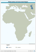
Seamless and topologically robust derivative of source VMap0 data layers for landmass and oceanic island data layers. The MASK_PY shapefile data layer is comprised of 2 derivative vector framework library features derived based on 1:1 000 000 data originally from VMap0, 5th Edition. The layer provides nominal analytical/mapping at 1:1 000 000. Data processing complete globally, this is an African subset. Acronyms and Abbreviations: VMap0 - Vector Map for Level 0.
-
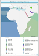
Seamless and topologically robust derivative of VMap0 -Ed5 polygonal Ocean/Sea data layers. The OCSEA_PY shapefile data layer is comprised of 25 derivative vector framework library features derived based on 1:1 000 000 data originally from VMap0, 5th Edition. The layer provides nominal analytical/mapping at 1:1 000 000. Data processing complete globally, this is an African subset. Acronyms and Abbreviations: VMap0 - Vector Map for Level 0.
-
Over the Hawaii region, climatology of the chlorophyll-a concentration for case 1 water (expressed in mg/m3). The climatology is based on the GlobColour (http://www.globcolour.info) products obtained by the merging of MERIS MODIS and SeaWIFS data available during the period 1998-2009. The mean value product represents the mean chlorophyll-a concentration obtained by merging for each of the 12 years the selected month (April). The spatial resolution of the product is about 4km. The product has been designed and produced by ACRI-ST INFOCEAN-DESK environment monitoring service from EU FP7 & ESA MyOcean GlobColour Products, ESA ENVISAT MERIS data, NASA MODIS and SeaWiFS data. The GlobColour project has been initiated and funded by the ESA Data User Element Programme to develop a satellite based ocean colour data service to support global carbon-cycle research. The GlobColour project has largely benefited from NASA contributions, including the availability of the MODIS and SeaWiFS products; the in situ data base of radiometric and phytoplankton pigment data, and other oceanographic and atmospheric data: the SeaWiFS Bio-optical Archive and Storage System - SeaBASS (Werdell and Bailey, 2002). The global merged chlorophyll-a concentration for case 1 water is obtained by the merging of MERIS, MODIS and SeaWiFS data using an advanced retrieval based on fitting an in-water bio-optical model to the merged set of observed normalised water-leaving radiances (nLw?s). This technique is termed GSM because it originates from the Garver et al. (1997) bio-optical model (Maritorena and Siegel, 2005). More details are available at http://www.globcolour.info/CDR_Docs/GlobCOLOUR_PUG.pdf.
-
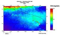
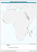
Oceanic point feature derivative of VMap0 - Ed5 Political Point data layer. The ISLND_PT shapefile data layer is comprised of 1474 derivative vector framework library features derived based on 1:1 000 000 data originally from VMap0, 5th Edition. The layer provides nominal analytical/mapping at 1:1 000 000. Data processing complete globally, this is an African subset. Acronyms and Abbreviations: VMap0 - Vector Map for Level 0.