 FAO Map Catalog
imageryBaseMapsEarthCover
Type of resources
Available actions
Topics
Keywords
Contact for the resource
Provided by
Years
Formats
Representation types
Update frequencies
status
Scale
Resolution
-
This dataset is a thematic reaggregated version of the original national Africover landcover multipurpose database. It contains all natural vegetation with a herbaceous component. The original full resolution land cover has been produced from visual interpretation of digitally enhanced LANDSAT TM images (Bands 4,3,2) acquired mainly in the year 1999 (see the "Multipurpose Landcover Database" metadata for more details). This dataset is intended for free public access. Thematic aggregation is the way that the end user customizes the Africover database to fulfil his/her specific requirements. The Africover database gives equal level of detail to Agriculture as well as Natural vegetation or Bare Areas etc. Generally a single user does not need this level of detail for each class type; therefore he/she will enhance the information of one land cover type and will generalize or erase the information related to other land cover aspects. The most powerful way to conduct an aggregation exercise is to use the classifiers as basic elements of the exercise. This gives the user the maximum flexibility on the use of data. The shape main attributes correspond to the following fields: -ID -HECTARES -GRASS_ID -GRASS_DESC You can download a zip archive containing: -the ke-grass-agg (.shp) -the Kenya Classifiers Used (.pdf) -the Kenya legend (.pdf and .xls) -the Kenya Legend - LCCS Import file (.xls) -the LCCS glossary_kenya(.pdf) -the thematic-aggregation-procedure (.pdf) -the thematic-aggregation-annex1 (.pdf) -the thematic-aggregation-annex2 (.pdf) -the Userlabel Definitions (.pdf)
-

Land use units in Botswana, that share geographical overlapping with the Okavango Basin. Source: The Botswana National Atlas (The Department of Survey and Mapping). This dataset is part of the GIS Database for the Environment Protection and Sustainable Management of the Okavango River Basin project (EPSMO). Detailed information on the database can be found in the “GIS Database for the EPSMO Project†document produced by Luis Veríssimo (FAO consultant) in July 2009, and here available for download.
-

This dataset is a thematic reaggregated version of the original national Africover landcover multipurpose database. It contains all natural vegetation with a woody component. The original full resolution land cover has been produced from visual interpretation of digitally enhanced LANDSAT TM images (Bands 4,3,2) acquired mainly in the year 1999 (see the "Multipurpose Landcover Database" metadata for more details). This dataset is intended for free public access. Thematic aggregation is the way that the end user customizes the Africover database to fulfil his/her specific requirements. The Africover database gives equal level of detail to Agriculture as well as Natural vegetation or Bare Areas etc. Generally a single user does not need this level of detail for each class type; therefore he/she will enhance the information of one land cover type and will generalize or erase the information related to other land cover aspects. The most powerful way to conduct an aggregation exercise is to use the classifiers as basic elements of the exercise. This gives the user the maximum flexibility on the use of data. The shape main attributes correspond to the following fields: -ID -HECTARES -GRASS_ID -GRASS_DESC You can download a zip archive containing: -the bu-grass-agg (.shp) -the Burundi Classifiers Used (.pdf) -the Burundi legend (.pdf and .xls) -the Burundi Legend - LCCS Import file (.xls) -the LCCS glossary (.pdf) -the thematic-aggregation-procedure (.pdf) -the thematic-aggregation-annex1 (.pdf) -the thematic-aggregation-annex2 (.pdf) -the Userlabel Definitions (.pdf)
-

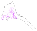
The full resolution land cover has been produced from visual interpretation of digitally enhanced high-resolution LANDSAT TM images (Bands 4,3,2) acquired mainly in the year 1999. The land cover classes have been developed using the FAO/UNEP international standard LCCS classification system. This database can be analyzed in the GLCN software Advanced Database Gateway (ADG), which provides a user-friendly interface and advanced functionalities to breakdown the LCCS classes in their classifiers for further aggregations and analysis. The ADG software is available for download on the GLCN web site at http://www.glcn.org/sof_7_en.jsp. The shape main attributes correspond to the following fields: -ID -USERLABER -LCCCODE (unique LCCS code) You can download a zip archive containing: -the dataset er-landcover-ge (.shp) -the Eritrea Classifiers Used (.pdf) -the Eritrea legend (.pdf and .xls) -the Eritrea Legend - LCCS Import file (.xls) -the Userlabel Definitions (.pdf) Note: the document Eritrea Classifiers Used.pdf, is a list of all the LCCS classifiers used in the study area. They are grouped under the 8 major land cover types. In addition to the standard classifiers contained in LCCS the user may find “user defined†classifiers used by the map producer to add additional information to a specific class, not available in LCCS. The user-defined attributes are always coded with the letter “Zâ€.
-
This dataset is a thematic reaggregated version of the original national Africover landcover multipurpose database. It contains all cultivated land. The original full resolution land cover has been produced from visual interpretation of digitally enhanced LANDSAT TM images (Bands 4,3,2) acquired mainly in the year 1999 (see the "Multipurpose Landcover Database" metadata for more details). This dataset is intended for free public access. Thematic aggregation is the way that the end user customizes the Africover database to fulfil his/her specific requirements. The Africover database gives equal level of detail to Agriculture as well as Natural vegetation or Bare Areas etc. Generally a single user does not need this level of detail for each class type; therefore he/she will enhance the information of one land cover type and will generalize or erase the information related to other land cover aspects. The most powerful way to conduct an aggregation exercise is to use the classifiers as basic elements of the exercise. This gives the user the maximum flexibility on the use of data. The shape main attributes correspond to the following fields: -ID -HECTARES -CULT_ID -CULT_DESC You can download a zip archive containing: -the er-cult-agg (.shp) -the Eritrea Classifiers Used (.pdf) -the Eritrea legend (.pdf and .xls) -the Eritrea Legend - LCCS Import file (.xls) -the LCCSglossary_eritrea (.pdf) -the thematic-aggregation-procedure (.pdf) -the thematic-aggregation-annex1 (.pdf) -the thematic-aggregation-annex2 (.pdf) -the Userlabel Definitions (.pdf)
-
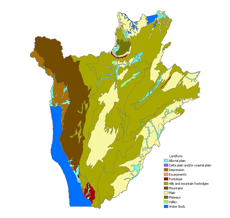
The full resolution dataset of landform and lithology has been produced from visual interpretation of digitally enhanced LANDSAT TM images acquired mainly in the year 1999. The landform classes have been developed using the ITC (International Institute for Geo-Information Science and Earth Observation) and SOTER (Soil and Terrain Database) methods. The structure of the derived legend follows a specific criteria that allows and easy correlation between these classes and the standardised one listed in LCCS (SOTER classification first and second level). SOTER is a pure Parametric or Morphometric classification. The main origin or process of terrain units is an important descriptive element because it realtes to the dominant exogenous or endogenous processes. this aspect in a general classification gives a meaningful grouping and has analytical value. The proposed legend is structured in such a way that it can be read, not only from the Morphometric point of view as in SOTER, but also taking into account the main origin and the age of landforms (mainly derived from the lithology legend). Lithology is linked with the mapping units, but is listed seperately. See the full landform/lithology legend in the resource section.
-

Farms plots, as of 2005, in Namibia, that share geographical overlapping with the Okavango Basin. Source: Ministry of Agriculture, Water and Forestry of Namibia. This dataset is part of the GIS Database for the Environment Protection and Sustainable Management of the Okavango River Basin project (EPSMO). Detailed information on the database can be found in the “GIS Database for the EPSMO Project†document produced by Luis Veríssimo (FAO consultant) in July 2009, and here available for download.
-
As part of the the World Bank's review of its rural development strategy, the Bank sought the assistance of the Food and Agriculture Organization of the United Nations (FAO) in evaluating how farming systems might change and adapt over the next thirty years. Amongst other objectives, the World Bank asked FAO to provide guidance on priorities for investment in food security, poverty reduction, and economic growth, and in particular to identify promising approaches and technologies that will contribute to these goals. The results of the study are summarized in a set of seven documents, comprising six regional reports and the global overview contained in this volume. This document, which synthesises the results of the six regional analyses as well as discussing global trends, cross-cutting issues and possible implementation modalities, presents an overview of the complete study. This document is supplemented by two case study reports of development issues of importance to farming systems globally.
-

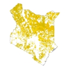
This full resolution land cover is an updated version of the Africover Kenya data base dated circa 1999. The dataset was created using the FAO/GLCN methodology and tools. The land cover mapping was carried out with the visual interpretation of digitally enhanced LANDSAT ETM images acquired mainly in the year 2000. The legend was prepared using the FAO/UNEP international standard Land Cover Classification System (LCCS): a comprehensive, standardized a priori classification system, designed to meet specific user requirements and created for mapping exercises, independent of the scale or means used to map. The classification uses a set of independent diagnostic criteria that allows the correlation with existing classifications and legends. The dataset can be analyzed in the GLCN software Advanced Database Gateway (ADG), which provides a user-friendly interface and advanced functionalities to breakdown the LCCS classes in their classifiers for further aggregations and analysis. Source: WRI/FAO/DRSRS List of abbreviations: DRSRS - Kenya Department of Resource Surveys and Remote Sensing FAO - Food and Agriculture Organization of the United Nations GLCN - Global Land Cover Network LCCS - FAO/UNEP Land Cover Classification System UNEP - United Nations Environmental Programme WRI - World Resources Institute