 FAO Map Catalog
health
Type of resources
Available actions
Topics
Keywords
Contact for the resource
Provided by
Years
Formats
Representation types
Update frequencies
status
Scale
Resolution
-

Rift Valley fever is an OIE list A disease.The map shows the last reported outbreaks of Rift Valley fever in different countries of Africa and Middle East
-

Rinderpest is an OIE List A disease. The standards, included in the International Animal Health Code, and known as the 'OIE Rinderpest Pathway', are the requirements that must be met to obtain official OIE recognition of country/zone freedom from this disease .The map shows the countries and zones by countries that are self-declared provisionally free from rinderpest disease. This information published by the OIE is derived from declarations made by the official Veterinary Services of Member Countries to OIE. The map shows also the countries recognised by OIE, as free from rinderpest disease and rinderpest infection.
-

Rift Valley fever is an OIE list A disease. The map shows potential suitable areas for Rift Valley fever in Africa and the Middle East. The model is the result of a spatial analysis combining four geographical layers, namely the Landcover classification, slopes, closed forest and the Digital Elevation Model. A suitability indicator was defined according to the biology of the vector of Rift Valley fever virus and the presence of susceptible hosts. This preliminary work should be further validated using ground-truth data (e.g. results of serological survey and entomological studies) and refined accordingly to restrict the geographical extension of high risk areas which might have been overestimated. Areas of North Africa and the Middle East have been included into the model in order to assess the potential risk of extension of the disease based on similar ecological conditions and the proximity to enzootic areas. However, the disease has never been reported in these areas which should be considered as free of the disease so far.
-
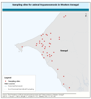
This dataset contains information on African animal trypanosomosis (AAT) in Western Senegal. Data were collected prior to the initiation of activities aimed at eliminating tsetse fly, the vector of the disease. Details on this dataset are availale in âThe Prevalence of African animal trypanosomoses and Tsetse presence in Western Senegalâ Seck M. T., Bouyer J., Sall B., Bengaly Z., Vreysen M. J. B., Parasite, 2010, 17, 257-265
-
Estimate of food self suffficieny based on population density and expressed in terms of the number of kilograms per person.The map also includes protected areas.
-
This dataset contains information on the apparent density of tsetse flies in three selected areas of Kenya (Lambwe Valley, Lake Bogoria and Meru/Mwea). It was genereated within the framework of a tsetse and trypanosomiasis elimination campaign (Pan-African tsetse and trypanosomiasis eradication campaign (PATTEC) - Kenya).
-

This map represents outbreaks of HPAI reported from 1st Jabuary to 7th of June 2006. The original data have been collected and aggregated at the most detailed administrative level and for the units available for each contry. NOTE: FAO compiles information from numerous sources (FAO, OIE, Official governamental sources, EC, Reference Laboratories and others) and cannot garantee the veracity of all the information given. The map will be updated as soon as additional information becomes available.
-
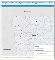
This dataset contains information on animal trypanosomiasis in the Upper West region of Ghana. It was generated within the framework of a tsetse and trypanosomiasis elimination campaign (Pan-African tsetse and trypanosomiasis eradication campaign (PATTEC) - Ghana).
-

The map shows potential suitable areas for Rift Valley fever in Sub-Saharan Africa. The map is the result of a spatial analysis combining four geographical layers, namely the Landcover classification, slopes, closed forest and the Digital Elevation Model. A suitability indicator was defined according to the biology of the vector of Rift Valley fever virus and the presence of susceptible hosts. This preliminary work should be further validated using ground-truth data (e.g. results of serological survey and entomological studies) and refined accordingly to restrict the geographical extension of high risk areas which might have been overestimated. The map is restricted to Sub-Saharan African and the Southern part of Middle East where the virus is known to be potentially present according to scientific literature and reported outbreaks. It differs from the map entitled "Rift Valley fever risk mapping" where areas of North Africa and the Middle East (e.g. Iraq) have been included into the model in order to assess the potential risk of extension of the disease based on similar ecological conditions and the proximity to enzootic areas. However, the disease has never been reported in these areas which should be considered as free of the disease so far.
-
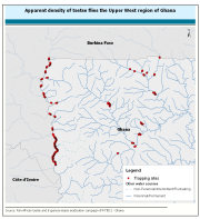
This dataset contains information on the apparent density of tsetse flies in the Upper West region of Ghana. It was generated within the framework of a tsetse and trypanosomosis elimination campaign (Pan-African tsetse and trypanosomosis eradication campaign (PATTEC) - Ghana).