 FAO Map Catalog
geoscientificInformation
Type of resources
Available actions
Topics
Keywords
Contact for the resource
Provided by
Years
Formats
Representation types
Update frequencies
status
Scale
Resolution
-
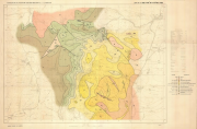
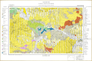
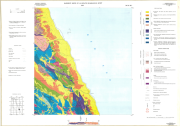
Geological map of Safad region
-
Include: Rawalpindi (Map No 24)
-
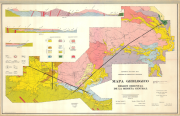
Soil Associations (2 500 000)
-
Include : Mapa de los grupos de suelos del Ecuador (Apendice 5) (Spanish) (1 000 000) Broad Soil Association of Ecuador (English) (1 000 000) (2 Sheets)
-

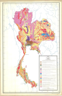
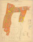
Distribution of liming resources in relation to acid soils in South Africa
-
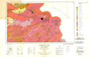
Include: Mapa geologico
-
Engineering capability for pond construction obtained by combining soil texture and slope. Soil texture was interpreted in terms of suitability for pond construction. Soil texture data was obtained from the FAO-UNESCO Soil Map of Africa at 1:5 million scale. This dataset includes three soil texture classes: coarse, medium and fine and these are given for the dominant soils of each association and refer only to the upper 30cm. Slope was interpreted in terms of suitability of topography for pond construction. Slope data was also obtained from the FAO-UNESCO Soil Map of Africa at 1:5 million scale. This dataset includes three slopes classes which reflect the topography in which the soil association occurs.
-
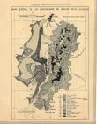
Include: Peta Tanah (Desa) Pasarminggu, Djatipadang, Ragunan, Djagakarsa (10 000)
-
Include: Central Tunisia; Kasserine
-
Basement rocks of Al Qusayr quadrangle (NG 36 K3)