 FAO Map Catalog
boundaries
Type of resources
Available actions
Topics
Keywords
Contact for the resource
Provided by
Years
Formats
Representation types
Update frequencies
status
Scale
Resolution
-
This dataset represents the administrative units 'Gewogs' which are the second-level subdivisions of Bhutan. The dataset was originally produced by the Department of Survey and Land Records under National Land Ministry, Bhutan. The data was sourced from FAO-Bhutan in March 2022, feature topology/geometry was corrected, and international borders validated against the United Nations official borders (United Nations Geospatial Information Section - UN-Map 2018). The dataset is part of FAO's Hand-in-Hand (HiH) second administrative level boundaries 2022 dataset series, published on the HiH Geospatial Platform for thematic mapping, integration of geospatially enabled statistics, zonal statistics extraction, and used for HiH initiative geospatial analysis (GIS-MCDA, suitability/location analysis, agricultural typologies).
-
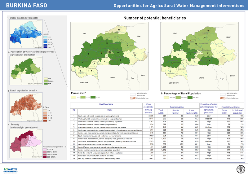
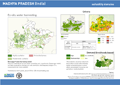
The potential for investment in agricultural water management (AWM) in support to rural livelihoods is assessed as a function of the demand from rural population and the availability (supply) of the resource. This map shows the distribution of rural population who could benefit from water-related interventions. The level of demand is based on the analysis of the livelihood zones, combined with poverty level. The supply is a function of availability of water, calculated on the basis of water (Internal renewable water resources) per person, with water development being constrained below the threshold 1700 m3/p.
-
-
Threatened to endangered species watershed boundaries based SAIAB and HYDRO1k. Source: SAIAB and HYDRO1k, "river" flow, and watershed networks based on the GTopo30. The AQSP_THRTND_PY shapefile data layer is comprised of 92 derivative polygon aquatic species features derived based on 1:2 000 000 data originally from SAIAB. The layer provides nominal analytical/mapping at 1:2 000 000. Acronyms and Abbreviations: SAIAB - South African Institute for Aquatic Biodiversity; HYDRO1k - Global Hydrological 1 kilometre database of hydrologically filled DEMs; DEM - Digital Elevation Model; GT30/GTopo30 - Global Topographic 30 arc second DEM database, nominal 1km postings.
-
Linear and polygonal coastal, country and bathymetry. The CADMN_PT shapefile data layer is comprised of 5409 derivative vector coastline - administrative features derived based on 1:250 000 data originally from WVS+. The layer provides nominal analytical/mapping at 1:250 000. Data processing complete globally, this is an African subset
-
This dataset represents the second-level administrative unit 'States' of Nigeria. The dataset was prepared by the Office of the Surveyor General of the Federation, Federal Surveys of Nigeria in February 2022 to Second Administrative Level Boundaries (SALB) Program of United Nations. The reference scale for this Geospatial data is equivalent to 1:1,000,000 scale, or larger scale. Data was downloaded from UN-SALB site in June 2022, feature topology/geometry was corrected, international borders validated against the United Nations official borders (United Nations Geospatial Information Section - UN-Map 2018). The dataset is part of FAO's Hand-in-Hand (HiH) second administrative level boundaries 2022 dataset series, published on the HiH Geospatial Platform for thematic mapping, integration of geospatially enabled statistics, zonal statistics extraction, and used for HiH initiative geospatial analysis (GIS-MCDA, suitability/location analysis, agricultural typologies).
-
This map shows areas suitable for the Agricultural Water Management interventions as identified by the project. The assessment is based primarily on each intervention's bio-physical requirements (such as: climate, proximity to water resources, terrain), but it also includes a qualitative rating based on socio-economic settings (namely distance to markets).
-
Linear and polygonal coastal, country and bathymetry. The CADMN_LN shapefile data layer is comprised of 6065 derivative vector coastline - administrative features derived based on 1:250 000 data originally from WVS+. The layer provides nominal analytical/mapping at 1:250 000. Data processing complete globally, this is an African subset
-
Ad3-Polygonal representation of 2nd-order subnational boundaries from country sources integrated with Ad1 boundaries from VMap0 and DCW. The AD3_PY shapefile data layer is comprised of 5690 derivative polygon african national-subnational areas features derived based on 1:1 000 000 data originally from FAO. The layer provides nominal analytical/mapping at 1:1 000 000. Acronyms and Abbreviations: VMap0 - Vector Map for Level 0; DCW - Digital Chart of the World FAO - Food and Agriculture Organization in the United Nations.
-
This dataset represents the third-level administrative unit 'freguesias' of Cape Verde. The dataset was originally produced by the Instituto Nacional de Gestão do Território (INGT), Cape Verde from 2010 administrative division. The reference scale for this Geospatial data is equivalent to 1:5,000 scale. The data was sourced from FAOCV in February 2022, feature topology/geometry was corrected, and international borders validated against the United Nations official borders (United Nations Geospatial Information Section - UN-Map 2018). The dataset is part of FAO's Hand-in-Hand (HiH) second administrative level boundaries 2022 dataset series, published on the HiH Geospatial Platform for thematic mapping, integration of geospatially enabled statistics, zonal statistics extraction, and used for HiH initiative geospatial analysis (GIS-MCDA, suitability/location analysis, agricultural typologies).