 FAO Map Catalog
Contact for the resource
USGS/EROS Data Center
Type of resources
Available actions
Topics
Keywords
Contact for the resource
Provided by
Years
Representation types
Update frequencies
status
Scale
From
1
-
2
/
2
-
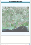
Enhanced natural color and 2.5d hillshade orthorectified image derivative, reprojected and mosaiced into single coverage of a Megabasin. Source: NASA Landsat Orthorectified MSS, TM and ETM+. The VOLTA_TM-SHD image data layer is comprised of 42465x46324 derivative image satellite based imagery features derived based on 28.5 metre data originally from TM.
-
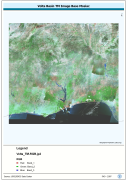
Enhanced natural color orthorectified image baseline, reprojected and mosiaced into single coverage of a Megabasin. Source: NASA Landsat Orthorectified MSS, TM and ETM+. The VOLTA_TM-RGB image data layer is comprised of 42465x46324 derivative image satellite based imagery features derived based on 28.5 metre data originally from TM.