 FAO Map Catalog
U.S. National Geospatial-Intelligence Agency (VMap0)
Type of resources
Available actions
Topics
Keywords
Contact for the resource
Provided by
Years
Representation types
Update frequencies
status
Scale
-
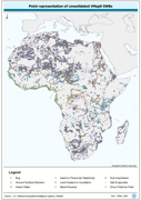
Robust centre-point derivative of SWB - Hydro polygonal features. The VMAP_PT shapefile data layer is comprised of 25128 derivative polygon framework library features derived based on 1:1 000 000 data originally from VMap0/DCW. The layer provides nominal analytical/mapping at 1:1 000 000. Seamlessly complete globally, with consolidation-harmonization @ ~70%, this Africa subset at final. Acronyms and Abbreviations: VMap0 - Vector Map for Level 0; SWB - Surface Water Body; DCW - Digital Chart of the World.
-
A dissolved version of the AVec_DBC data using ArcView to ensure any summary SWB or watershed statistical data are not double counted. The VMAP_SUM_AD2 shapefile data layer is comprised of 699 derivative polygon surface water bodies by admin units features derived based on 1:1 000 000 data originally from VMap0. The layer provides nominal analytical/mapping at 1:1 000 000. Acronyms and Abbreviations: SWB - Surface Waterbody.
-
Seamless and topologically robust derivative of VMap0 - Ed5 data layers. The PPL_PY shapefile data layer is comprised of 1505 derivative vector framework library features derived based on 1:1 000 000 data originally from VMap0, 5th Edition. The layer provides nominal analytical/mapping at 1:1 000 000. Data processing complete globally, this is an African subset. Acronyms and Abbreviations: VMap0 - Vector Map for Level 0.
-
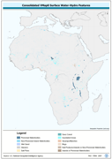
Seamless and topologically robust derivative of source VMap0 SWB and related hydrological features, i.e. swamps, etc. data layers. The VMAP_PY shapefile data layer is comprised of 25128 derivative vector framework library features derived based on 1:1 000 000 data originally from VMap0/DCW. The layer provides nominal analytical/mapping at 1:1 000 000. Seamlessly complete globally, with consolidation-harmonization @ ~70%, this Africa subset at final. Acronyms and Abbreviations: VMap0 - Vector Map for Level 0; SWB - Surface Water Body DCW - Digital Chart of the World.
-
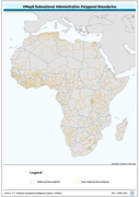
Ad2-Seamless and topologically robust derivative of all polygonal VMap0 - Ed5 coastal, national, subnational and sovereign boundary data layers cross-checked against related linear vectors. The AD2_PY shapefile data layer is comprised of 1753 derivative vector framework library features based on data from VMap0, 5th Edition. The layer provides analytical/mapping at 1:1 000 000. Data processing complete globally, this is an African subset. Acronyms and Abbreviations: VMap0 - Vector Map for Level 0.
-
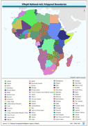
Ad1-Seamless and topologically robust derivative of all polygonal VMap0 - Ed5 coastline and national/sovereign boundary data layers cross-checked against related linear vectors. The AD1_PY shapefile data layer is comprised of 1122 derivative vector framework library features derived based on 1:1 000 000 data originally from VMap0, 5th Edition. The layer provides nominal analytical/mapping at 1:1 000 000. Data processing complete globally, this is an African subset. Acronyms and Abbreviations: VMap0 - Vector Map for Level 0.
-
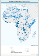
Robust derivative of VMap0 - Ed5 data layers harmonized with DCW dams, lakes, waterholes, wells and other SWBs based on the VMAP0-MP and DCW-DN/DSPNT sources. The DNIW_PNT shapefile data layer is comprised of 19230 derivative vector surface water bodies features derived based on 1:1 000 000 data originally from VMap0/DCW. The layer provides nominal analytical/mapping at 1:1 000 000. Seamlessly complete globally, with consolidation-harmonization @ ~70%, this Africa subset at final. Acronyms and Abbreviations: VMap0 - Vector Map for Level 0; DCW - Digital Chart of the World; SWBs - Surface Waterbodies, DNNET - Drainage Network layer; LCPOLY - Land Cover layer.
-
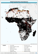
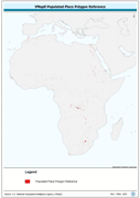
Robust derivative of VMap0 - Ed5 Populated Place data layer. The PPL_PT shapefile data layer is comprised of 39172 derivative vector framework library features derived based on 1:1 000 000 data originally from VMap0, 5th Edition. The layer provides nominal analytical/mapping at 1:1 000 000. Data processing complete globally, this is an African subset. Acronyms and Abbreviations: VMap0 - Vector Map for Level 0.
-
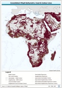
Seamless and topologically robust derivative of all linear VMap0 - Ed3 bathymetric, coastline, and terrain contour data layers. The HYPSO_LN shapefile data layer is comprised of 108715 derivative vector framework library features derived based on 1:1 000 000 data originally from VMap0 | 5th Edition. The layer provides nominal analytical/mapping at 1:1 000 000. Data processing 75% complete globally, with African subset 100% complete. Acronyms and Abbreviations: VMap0 - Vector Map for Level 0.
-
Robust derivative of VMap0 - Ed5 data layers with harmonized encoding. The CAPTL_PT shapefile data layer is comprised of 55 derivative vector framework library features derived based on 1:1 000 000 data originally from VMap0, 5th Edition. The layer provides nominal analytical/mapping at 1:1 000 000. Data processing complete globally, this is an African subset. Acronyms and Abbreviations: VMap0 - Vector Map for Level 0.