 FAO Map Catalog
LIB/00/04 - "Mapping of Natural Resources for Agricultural Use and Planning" project in Libya
Type of resources
Topics
Keywords
Contact for the resource
Provided by
Formats
Representation types
Update frequencies
status
Scale
-
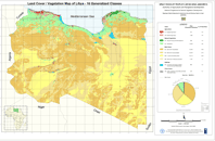
This data set is a re-aggregated version of the full resolution Libyan land cover database. The original full resolution data has been concentrated in few generalized classes highlighting the most relevant features mapped without loosing information. The result is an aggregation of 10 generalized classes listed below, which keeps a good level of information, giving at the same time an exact estimation of the areas covered by each aggregated class. The 10 Generalized Classes aggregation Land Cover map of Libya: AGRICULTURE AI - Irrigated Agriculture AR - Rainfed Agriculture NATURAL VEGETATION NF - Natural Forest and Reforestations NV - Rangeland BARE AREAS BC - Bare Soil Consolidated BU - Bare Soil Unconsolidated BSn - Loose and Shifting Sand BW - Bare Soil in Wadi Environment SABKHAS SK - Terrestrial and Aquatic Sabkha Environment and Waterbodies URBAN AREAS UB - Urban areas, Quarries and Dump Sites The land cover products were developed by FAO as part of the LIB/00/04 'Mapping of Natural Resources for Agriculture Use and Planning Project in Libya'. This project was initiated by the Government of Libya, FAO and the United Nations Development Programme (UNDP) to strengthen the capacity of the General People's Committee for Agriculture, Animal and Marine Wealth (GAAAMW) to manage land resources at national and sub-national levels through the establishment of a strategy, and a spatially based operational decision support system - the Land Resources Information Management System (LRIMS).