 FAO Map Catalog
Contact for the resource
Global International Waters Assessment
Type of resources
Available actions
Topics
Keywords
Contact for the resource
Provided by
Years
Representation types
Update frequencies
status
Scale
From
1
-
1
/
1
-
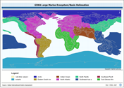
GIWA_LME: Global International Waters Assessment's Terrestrial WSs and Large Marine Ecosystems, a medium resolution WS delineation based on terrestrial modifications to the NOAA-URI Large Marine Ecosystems. The GIWA_LME shapefile data layer is comprised of 2936 derivative vector large marine ecosystems and terrestrial basins features derived based on ~100 000 cell data originally from GIWA - URI. The layer provides nominal analytical/mapping at 1:20 000 00. Data processing is complete and under revision globally. NOAA - U.S. National Oceanographic & Atmospheric Administration; URI - University of Rhode Islands, USA; GIWA - Global International Water Assessment watershed delineation; LME - Large Marine Ecosystems.