 FAO Map Catalog
FAO - Fisheries Department - Aquatic Resource Management Programme
Type of resources
Available actions
Topics
Keywords
Contact for the resource
Provided by
Years
Representation types
Update frequencies
status
Scale
-
Derived from 1:250 000 scale topographic maps and information from SADC host country ministries on impondments and reservoirs. The SWB_SADC tabular data layer is comprised of 18098 derivative tabular/point sadc lakes, dams and reservoirs features derived based on 1:250 000 data originally from ALCOM. The layer provides nominal analytical/mapping at 1:250 000. Acronyms and Abbreviations: SADC - The Southern African Development Community; WRD - The original SADC Water Resource Database produced by ALCOM; ALCOM - ALCOM - Aquatic Resource Management for Local Community Development Programme; SWB - Surface Water Body.
-
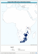
Enhanced derivative based on the original SADC-WRD database of lakes & impoundments, the SADC_SWB shapefile data layer is comprised of 18098 polygons, lakes, dams and reservoirs features derived based on 1:250 000 data originally from ALCOM. Acronyms and Abbreviations: SADC - The Southern African Development Community; WRD - The original SADC Water Resource Database produced by ALCOM; ALCOM - Aquatic Resource Management for Local Community Development Programme; SWB - Surface Water Body.