 FAO Map Catalog
FAO/Southern Sudan Sub-programme, Juba, Southern Sudan
Type of resources
Available actions
Topics
Keywords
Contact for the resource
Provided by
Years
Representation types
Update frequencies
status
-
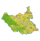
This land cover dataset provides information on the land cover distribution by sub-basin divisions. The dataset was created using the FAO/GLCN methodology and tools. The land cover mapping was carried out with the interpretation of an integrated coverage of GLS Landsat satellite images (2000 and circa 2005-2007) acquired for the whole extent of South Sudan, and improved with updated higher resolution SPOT images (2006-2008) covering the agricultural areas. This approach was adopted to emphasize the land cover features in the agricultural production areas which were derived from the existing Africover Sudan data base dated circa 2002. The legend was prepared using the Land Cover Classification System (LCCS*). The sub-basins division of the land cover comes from the South Sudan hydrological basins layer (USGS HydroSHEDS) which identifies the following nineteen sub-basins: Akoba, Bahr al arab, Baro Wenz, Buhayrat abyad, Gelha, Khawr biban, Khawr tunbak, Khawr_marchar, Kidepo, Kwahr as sidrah, Kwahr m’ boloko, Lake turkana, Lotagipi swamp, Sopo, Sue, White nile 3, White nile 4, White nile 5 and White nile 6. *The LCCS is a comprehensive, standardized a priori classification system, designed to meet specific user requirements and created for mapping exercises, independent of the scale or means used to map. The classification uses a set of independent diagnostic criteria that allows the correlation with existing classifications and legends.