 FAO Map Catalog
water temperature
Type of resources
Available actions
Topics
Keywords
Contact for the resource
Provided by
Years
Representation types
Update frequencies
status
Scale
-
Consolidated table of water temperature. The WT_MNTHY tabular data layer is comprised of 1004351 derivative raster water temperature features derived based on 0.5 degrees resolution data originally from CRES/FAO. The layer provides nominal analytical/mapping at 1:220 000 000. Acronyms and Abbreviations: CRES - Centre for Resource and Environmental Studies, The Australian National University (ANU); FAO - Food and Agriculture Organization in the United Nations.
-
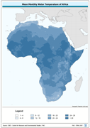
Predicted mean monthly water temperature (annual). Predictions based on air temperature estimates by the Center for resource and Enviornmental Studies (CRES) which can be interpreted as estimates of standard means for the period of 1920 to 1980 and mean annual wind velocity estimated by UNEP/GRID. The WATTMP_MN grid data layer is comprised of 1450x1380 derivative raster water temperature features derived based on 0.05 degrees resolution data originally from CRES/FAO. The layer provides nominal analytical/mapping at 1:20 000 000. Madagascar not included. The following layers are also vailable for download: Majority Monthly Water Temperature (Annual) Maximum Monthly Water Temperature (Annual) Median Monthly Water Temperature (Annual) Minimum Monthly Water Temperature (Annual) Minority Monthly Water Temperature (Annual) Range of Monthly Water Temperature (Annual) Monthly Water Temperature from January to December Acronyms and Abbreviations: CRES - Centre for Resource and Environmental Studies, The Australian National University (ANU); FAO - Food and Agriculture Organization of the United Nations; UNEP - United Nations Environment Programme