 FAO Map Catalog
water balance
Type of resources
Available actions
Topics
Keywords
Contact for the resource
Provided by
Years
Formats
Representation types
Update frequencies
status
Resolution
-
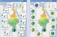
This map shows the results of a distributed water balance model used by FAO to assess the impact of irrigated agriculture on river basin flows. Based on a 5 arc minute cell size (approximately 10 km2 at the Equator), daily rainfall and evapotranspiration data are used to generate outflows at both the country and sub-basin levels. The resulting water balances for each sub-basin are calibrated on mean flows reported by Sutcliffe and Parks (1999). Full details of the model results are given in the FAO Nile Information Products Synthesis Report.
-
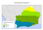
The Length of Growing Period (LGP) refers to the average duration when moisture availability allows crop growth. The calculation is based on a water balance model that compares moisture supply from precipitation, soil moisture storage and a reference evapotranspiration. The reference LGP assumes available soil moisture capacity of 100 mm per meter soil depth and a reference soil depth of one meter. LGP's were based on the baseline period of 1961-1990. This dataset has been used to complement the survey data and included in the "Climate change predictions in Sub-Saharan Africa: impacts and adaptations (ClimAfrica)" project, Work Package 5 (WP5). More information on ClimAfrica project is provided in the Supplemental Information section of this metadata. This study in WP5 aimed to identify, locate and characterize groups that are vulnerable for climate change conditions in two country clusters; one in West Africa (Benin, Burkina Faso, Côte d'Ivoire, Ghana, and Togo) and one in East Africa (Sudan, South Sudan and Uganda). Data used for the study include the Demographic and Health Surveys (DHS) , the Multi Indicator Cluster Survey (MICS) and the Afrobarometer surveys for the socio-economic variables and grid level data on agro-ecological and climatic conditions.
-
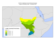
The Length of Growing Period (LGP) refers to the average duration when moisture availability allows crop growth. The calculation is based on a water balance model that compares moisture supply from precipitation, soil moisture storage and a reference evapotranspiration. The reference LGP assumes available soil moisture capacity of 100 mm per meter soil depth and a reference soil depth of one meter. LGP's were based on the baseline period of 1961-1990. This dataset has been used to complement the survey data and included in the "Climate change predictions in Sub-Saharan Africa: impacts and adaptations (ClimAfrica)" project, Work Package 5 (WP5). More information on ClimAfrica project is provided in the Supplemental Information section of this metadata. This study in WP5 aimed to identify, locate and characterize groups that are vulnerable for climate change conditions in two country clusters; one in West Africa (Benin, Burkina Faso, Côte d'Ivoire, Ghana, and Togo) and one in East Africa (Sudan, South Sudan and Uganda). Data used for the study include the Demographic and Health Surveys (DHS) , the Multi Indicator Cluster Survey (MICS) and the Afrobarometer surveys for the socio-economic variables and grid level data on agro-ecological and climatic conditions.
-
Etc and yield reduction for major crops in case study areas of Burkina, Malawi, Kenya, Sudan, Togo and Ghana (1980-2100). Input Parameters for Climate: daily Minimum and Maximum Temperature, Precipitation and solar radiation. Input Parameters for Soil: Texture, Depth, Drainage, Slope, pH, Organic content, Ece, EXP. Input Sources for Climate: 3 GCMs (MIROC5, CanESM2 and NOAA-GFDL) statistically downscaled (SOMDS) by UCT and dynamically downscaled (SMHI-RCM) from CORDEX experiment at 0.5°, RCP 8.5. Input Sources for Soil: information from WP6 and from HWSD. This data set has been produced in the framework of the "Climate change predictions in Sub-Saharan Africa: impacts and adaptations (ClimAfrica)" project, Work Package 3 (WP3). WP3 aimed at quantifying the sensitivity of vegetation productivity and water resources to seasonal, inter-annual and decadal variability in weather and climate, using impact models on agriculture and water. The available models in combination with developed datasets of land use and climate from WP2 were used to simulate crop yield and water resources. Simulations using short-term scenarios of future climate change (5-10 years) were used to identify regional differences in the climate sensitivity of crop production etc. Scenarios for the African agricultural/pastoral sectors were also made using longer model runs. Finally, tradeoffs and areas of risk and vulnerability were identified in relation to: - Water-related hazards; - Agricultural and pastoral performance; - Soil degradation. More information on ClimAfrica project is provided in the Supplemental Information section of this metadata.