 FAO Map Catalog
terrain
Type of resources
Available actions
Topics
Keywords
Contact for the resource
Provided by
Years
Formats
Representation types
Update frequencies
status
Scale
-
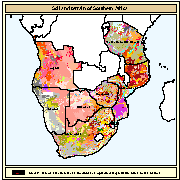
The compilation of a Soil and Terrain digital database for the South-African region forms a part of the ongoing activities of the Food and Agriculture Organisation of the United Nations (FAO) and the International Soil Reference and Information Centre (ISRIC) to update the world's baseline information on natural resources. The updating of world soil resources, using the Soil and Terrain (SOTER) digital database methodology, is part of a global SOTER programme and intended to replace the FAO/Unesco 1:5 million scale Soil Map of the World (1971-1981). The African sheet of this map was published in 1973 and has been compiled on basis of information and data available at that time. It is understandable that a substantial part does not reflect the present state of knowledge of the soils in that region. The national institutes, responsible for the natural resources inventories, have been collecting a wealth of new information on the distribution and occurrence of soils in their region, which has resulted in updating their national soil maps mostly at scale 1:1 million, often applying the Revised Legend (FAO, UNEP, ISRIC, 1988) for the description of the mapping units. The International Union of Soil Science (IUSS) adopted an important change in the classification used for the map by introducing lower levels of subunits of the World Reference Base for Soil Resources (IUSS, FAO, ISRIC, 1998). This, together with the new soil data available at national level, justified such an update of the soil resources for the Southern African region. The compilation of a Soil and Terrain digital database for the South-African region forms a part of the ongoing activities of the Food and Agriculture Organisation of the United Nations (FAO) and the International Soil Reference and Information Centre (ISRIC) to update the world?s baseline information on natural resources. The updating of world soil resources, using the Soil and Terrain (SOTER) digital database methodology, is part of a global SOTER programme and intended to replace the FAO/Unesco 1:5 million scale Soil Map of the World (1971-1981). The African sheet of this map was published in 1973 and has been compiled on basis of information and data available at that time. It is understandable that a substantial part does not reflect the present state of knowledge of the soils in that region. The national institutes, responsible for the natural resources inventories, have been collecting a wealth of new information on the distribution and occurrence of soils in their region, which has resulted in updating their national soil maps mostly at scale 1:1 million, often applying the Revised Legend (FAO, UNEP, ISRIC, 1988) for the description of the mapping units. The International Union of Soil Science (IUSS) adopted an important change in the classification used for the map by introducing lower levels of subunits of the World Reference Base for Soil Resources (IUSS, FAO, ISRIC, 1998). This, together with the new soil data available at national level, justified such an update of the soil resources for the Southern African region.
-

The compilation of a Soil and Terrain digital database for the South-African region forms a part of the ongoing activities of the Food and Agriculture Organisation of the United Nations (FAO) and the International Soil Reference and Information Centre (ISRIC) to update the world?s baseline information on natural resources. The updating of world soil resources, using the Soil and Terrain (SOTER) digital database methodology, is part of a global SOTER programme and intended to replace the FAO/Unesco 1:5 million scale Soil Map of the World (1971-1981). The African sheet of this map was published in 1973 and has been compiled on basis of information and data available at that time. It is understandable that a substantial part does not reflect the present state of knowledge of the soils in that region. The national institutes, responsible for the natural resources inventories, have been collecting a wealth of new information on the distribution and occurrence of soils in their region, which has resulted in updating their national soil maps mostly at scale 1:1 million, often applying the Revised Legend (FAO, UNEP, ISRIC, 1988) for the description of the mapping units. The International Union of Soil Science (IUSS) adopted an important change in the classification used for the map by introducing lower levels of subunits of the World Reference Base for Soil Resources (IUSS, FAO, ISRIC, 1998). This, together with the new soil data available at national level, justified such an update of the soil resources for the Southern African region. The compilation of a Soil and Terrain digital database for the South-African region forms a part of the ongoing activities of the Food and Agriculture Organisation of the United Nations (FAO) and the International Soil Reference and Information Centre (ISRIC) to update the world?s baseline information on natural resources. The updating of world soil resources, using the Soil and Terrain (SOTER) digital database methodology, is part of a global SOTER programme and intended to replace the FAO/Unesco 1:5 million scale Soil Map of the World (1971-1981). The African sheet of this map was published in 1973 and has been compiled on basis of information and data available at that time. It is understandable that a substantial part does not reflect the present state of knowledge of the soils in that region. The national institutes, responsible for the natural resources inventories, have been collecting a wealth of new information on the distribution and occurrence of soils in their region, which has resulted in updating their national soil maps mostly at scale 1:1 million, often applying the Revised Legend (FAO, UNEP, ISRIC, 1988) for the description of the mapping units. The International Union of Soil Science (IUSS) adopted an important change in the classification used for the map by introducing lower levels of subunits of the World Reference Base for Soil Resources (IUSS, FAO, ISRIC, 1998). This, together with the new soil data available at national level, justified such an update of the soil resources for the Southern African region.
-
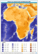
ETOPO2 2 arc-minute Terrain and Bathymetric DEM. The ETOPO2 grid data layer is comprised of 5400x10800 derivative raster bathymetry features derived based on 0.03333_ data originally from ETOPO2. Acronyms and Abbreviations: ETOPO2 - A 2 minute Elevation Topographic DEM including bathymetry DEM - Digital Elevation Model
-
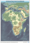
RGB color image of nominal 3.7 Km bathymetry and terrestrial elevation values. RGB is 3 band spatial imagery forced into the Red:Green:Blue spectrum. The ETOPO2_2-5D image data layer is comprised of 5400x10800 derivative raster bathymetry features derived based on 0.03333_ data originally from ETOPO2.
-
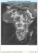
Grayscale image of nominal 3.7 Km bathymetry and terrestrial elevation values. The ETOPO2_SHD image data layer is comprised of 5400x10800 derivative raster hillshade | bathymetry features derived based on 0.03333_ data originally from ETOPO2.
-
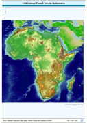
A Shaded relief image based on the first globally available elevation model. The AFRICA_BACKGROUND image data layer is comprised of 973x985 derivative raster bathymetry and elevation features derived based on 0.08333_ data originally from ETOPO5.
-

RGB color image of nominal 3.7 Km bathymetry and terrestrial elevation values. RGB is 3 band spatial imagery forced into the Red:Green:Blue spectrum. The ETOPO2_RGB image data layer is comprised of 5400x10800 derivative raster bathymetry features derived based on 0.03333_ data originally from ETOPO2.
-
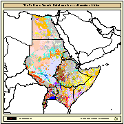
The SEA (Soil and Terrain Database Map of East Africa) is a Digital Soil Map at 1:1000000 scale for the following countries: Burundi, Djibouti, Egypt, Eritrea, Ethiopia, Kenya, Somalia, Sudan, Rwanda, and Uganda. Compilation of the SEA was subcontracted to ISRIC (Netherlands) by FAO in 1988. The main purpose, at that time, was to test the validity of the 1988 revision of the FAO/Unesco legend for the Soil Map of the World at 1:1 million scale. In 1990, the maps and the related tabular databases were automated (converted into digital form), in the FAO Geographic Information System Centre. The final version as been completed and made available in CD-ROM since 1998.
-

The major source of geo-referenced soil data of Latin America and the Caribbean at a scale of 1:5 M is the Soil Map of the World (SMW) of FAO/Unesco (1974-1981). For this part of the globe the information was collected before 1974, the year of publication of the Latin American map sheets. Collection of soil survey information by the national institutes responsible for soil survey continued after publication and a large amount of new data is available at the national level. Since 1991 the FAO is actualizing the SMW information of Latin America with support from national soils institutes in the concerned countries. This has resulted in the acquisition of new 1:5 M soil maps of most Latin American countries. New soil maps with a revised soil classification legend (FAO, 1990) of Argentina, Brazil, Chile, Colombia, Ecuador, Mexico, Paraguay, Peru, Uruguay and Venezuela were obtained by FAO through subcontracts with the national soil institutes. Since 1988 the World Soils and Terrain Database Programme (SOTER) is operational in various Latin American countries at a scale of 1:1 M, in particular in Argentina, Brazil and Uruguay with UNEP funding. The major objective of the SOTER methodology is to use information technology, like geographic information systems and database management systems, for the creation of a world soils and terrain database with digital maps and attributes and their interpretations. At the moment SOTER databases at scale 1:1 M are available for the whole of Uruguay, the northern part of Argentina (460,000 km2) and the south of Brazil (100,000 km2). In 1992 FAO formally endorsed SOTER and decided to use the methodology to store and update soils and terrain data at a global level. The SOTER Procedures Manual was published jointly by FAO, ISRIC, ISSS and UNEP in 1993 and in the following year also as No. 74 in the series of World Soil Resources Bulletins. During the same year an agreement was signed between FAO and UNEP to develop a soils and terrain database of Latin America at scale 1:5 M, jointly with the updating of the SMW. ISRIC was asked to coordinate the activities of the SOTERLAC 1:5 M project in the countries to be included.
-

AEZ classification by climate, soil, terrain and land cover (57 classes) at about 1 km resolution at the equator, using different climate data source and based on different Representative Concentration Pathways (RCPs) according to the time period as follows: - climate data source CRUTS32 based on historical data for the time period 1981-2010; - climate data source ENSEMBLE based on the Representative Concentration Pathway RCP8.5 for time periods 2041-2070 and 2071-2100. The AEZ classification by climate, soil, terrain and land cover dataset is part of the GAEZ v4 Theme 1 Land and Water Resources, Agro-Ecological Zones sub-theme. The agro-ecological zones classification provides a characterization of bio-physical resources relevant to agricultural production systems. AEZ definitions and map classes follow a rigorous methodology and an explicit set of principles. The inventory combines spatial layers of thermal and moisture regimes with broad categories of soil/terrain qualities. It also indicates locations of areas with irrigated soils and shows land with severely limiting bio-physical constraints including very cold and very dry (desert) areas as well as areas with very steep terrain or very poor soil/terrain conditions. For further details, please refer to the GAEZ v4 Model Documentation.