 FAO Map Catalog
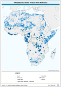
surface water bodies
Type of resources
Available actions
Topics
Keywords
Contact for the resource
Provided by
Years
Formats
Representation types
Update frequencies
status
Scale
-
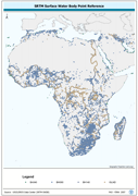
Centroid point locations of SWB, Double-Lined River and inshore island features. The SWBD_PT shapefile data layer is comprised of 38840 derivative vector surface water bodies features derived based on 1:100 000 data originally from SRTM-SWBD. The layer provides nominal analytical/mapping at 1:125 000. Data processing 60% complete globally, with African and Arabian subsets 100% complete. Acronyms and Abbreviations: SWB or SWBD - Surface Water Body; SRTM - Shuttle Radar Topography Mission.
-

Enhanced derivative based on annotation layers of DNNET and DNPNT sources of the DCW (Digital Chart of the World) translated into point features. The DNNET_PT shapefile data layer is comprised of 4808 derivative vector surface water bodies features derived based on 1:1 000 000 data originally from DCW. The layer provides nominal analytical/mapping at 1:1 000 000. Acronyms and Abbreviations: DNNET - DCW Drainage Network layer DCW - Digital Chart of the World.
-
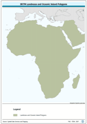
Seamless polygonal continental landmass and oceanic island mask data layer derived from SRTM-SWBD tiled database. The MASK_PY shapefile data layer is comprised of 4333 derivative vector surface water bodies features derived based on 1:100 000 data originally from SRTM-SWBD. The layer provides nominal analytical/mapping at 1:125 000. Data processing 60% complete globally, with African and Arabian subsets 100% complete. Acronyms and Abbreviations: SRTM - Shuttle Radar Topography Mission; SWBD - Surface water Body.
-
Seamless and robust derivative of SWB, Double-Lined River, and Inshore Island Features from SRTM-SWBD data tiles. The SWBD_PY shapefile data layer is comprised of 38840 derivative vector surface water bodies features derived based on 1:100 000 data originally from SRTM-SWBD. The layer provides nominal analytical/mapping at 1:125 000. Data processing 60% complete globally, with African and Arabian subsets 100% complete. Acronyms and Abbreviations: SWB or SWBD - Surface Water Body; SRTM - Shuttle Radar Topography Mission.
-

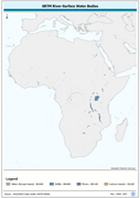
Linear representation of SWB, Double-Lined River, and Inshore Island Features. The SWBD_LN shapefile data layer is comprised of 54741 derivative vector surface water bodies features derived based on 1:100 000 data originally from SRTM-SWBD. The layer provides nominal analytical/mapping at 1:125 000. Data processing 60% complete globally, with African and Arabian subsets 100% complete. Acronyms and Abbreviations: SWB or SWBD - Surface Water Body; SRTM - Shuttle Radar Topography Mission.
-
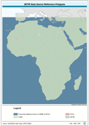
Polygonal seamless representation of SRTM Digital Elevation Model source reference. The SRC_PY shapefile data layer is comprised of 7536 derivative vector surface water bodies features derived based on 1:100 000 data originally from SRTM-SWBD. The layer provides nominal analytical/mapping at 1:125 000. Data processing 60% complete globally, with African and Arabian subsets 100% complete. Acronyms and Abbreviations: DEM - Digital Elevation Model; SRTM - Shuttle Radar Topography Mission.
-

Linear representation of the nominal 30 metre coastlines; this is the highest resolution determinate currently available. The CSTLN_LN shapefile data layer is comprised of 11070 derivative vector surface water bodies features derived based on 1:100 000 data originally from SRTM-SWBD. The layer provides nominal analytical/mapping at 1:125 000. Data processing 60% complete globally, with African and Arabian subsets 100% complete. Acronyms and Abbreviations: SRTM - Shuttle Radar Topography Mission; SWBD - Surface water Body.
-
Robust derivative of VMap0 - Ed5 data layers harmonized with DCW dams, lakes, waterholes, wells and other SWBs based on the VMAP0-MP and DCW-DN/DSPNT sources. The DNIW_PNT shapefile data layer is comprised of 19230 derivative vector surface water bodies features derived based on 1:1 000 000 data originally from VMap0/DCW. The layer provides nominal analytical/mapping at 1:1 000 000. Seamlessly complete globally, with consolidation-harmonization @ ~70%, this Africa subset at final. Acronyms and Abbreviations: VMap0 - Vector Map for Level 0; DCW - Digital Chart of the World; SWBs - Surface Waterbodies, DNNET - Drainage Network layer; LCPOLY - Land Cover layer.
-
Geo-referenced point database on dams in the Middle East.
-
Geo-referenced point database on dams in Africa.