 FAO Map Catalog
surf. water bodies
Type of resources
Available actions
Topics
Keywords
Contact for the resource
Provided by
Years
Formats
Representation types
Update frequencies
status
Scale
-
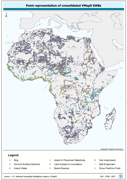
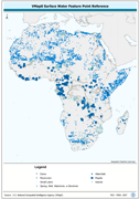
Robust centre-point derivative of SWB - Hydro polygonal features. The VMAP_PT shapefile data layer is comprised of 25128 derivative polygon framework library features derived based on 1:1 000 000 data originally from VMap0/DCW. The layer provides nominal analytical/mapping at 1:1 000 000. Seamlessly complete globally, with consolidation-harmonization @ ~70%, this Africa subset at final. Acronyms and Abbreviations: VMap0 - Vector Map for Level 0; SWB - Surface Water Body; DCW - Digital Chart of the World.
-
Seamless and topologically robust derivative of source VMap0 SWB and related hydrological features, i.e. swamps, etc. data layers. The VMAP_PY shapefile data layer is comprised of 25128 derivative vector framework library features derived based on 1:1 000 000 data originally from VMap0/DCW. The layer provides nominal analytical/mapping at 1:1 000 000. Seamlessly complete globally, with consolidation-harmonization @ ~70%, this Africa subset at final. Acronyms and Abbreviations: VMap0 - Vector Map for Level 0; SWB - Surface Water Body DCW - Digital Chart of the World.
-
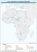
Robust separately encoded depiction of the SWB - Hydro polygonal outlines. The VMAP_LN shapefile data layer is comprised of 30413 derivative polygon framework library features derived based on 1:1 000 000 data originally from VMap0/DCW. The layer provides nominal analytical/mapping at 1:1 000 000. Seamlessly complete globally, with consolidation-harmonization @ ~70%, this Africa subset at final. Acronyms and Abbreviations: VMap0 - Vector Map for Level 0; SWB - Surface Water Body; DCW - Digital Chart of the World.
-
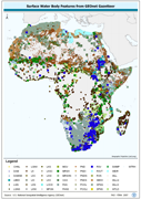
GNS_SWB: Surface Water Bodies based on named locations GNS/GeoNet Gazetteer. The GNS_SWB shapefile data layer is comprised of 46591 derivative point gazetteer features derived based on 1:250 000 data originally from GEOnet. The layer provides nominal analytical/mapping at 1:250 000. Data processing is complete globally, this is an African subset. Acronyms and Abbreviations: GNS/GeoNet Gazetteer - NIMA's Geographic Names Server Gazetteer of Named Locations; SWB - Surface Water Body.
-
Derived from 1:250 000 scale topographic maps and information from SADC host country ministries on impondments and reservoirs. The SWB_SADC tabular data layer is comprised of 18098 derivative tabular/point sadc lakes, dams and reservoirs features derived based on 1:250 000 data originally from ALCOM. The layer provides nominal analytical/mapping at 1:250 000. Acronyms and Abbreviations: SADC - The Southern African Development Community; WRD - The original SADC Water Resource Database produced by ALCOM; ALCOM - ALCOM - Aquatic Resource Management for Local Community Development Programme; SWB - Surface Water Body.
-
A dissolved version of the AVec_DBC data using ArcView to ensure any summary SWB or watershed statistical data are not double counted. The VMAP_SUM_AD2 shapefile data layer is comprised of 699 derivative polygon surface water bodies by admin units features derived based on 1:1 000 000 data originally from VMap0. The layer provides nominal analytical/mapping at 1:1 000 000. Acronyms and Abbreviations: SWB - Surface Waterbody.
-
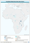
Robust derivative of VMap0 - Ed5 data layers harmonized with DCW dams, lakes, waterholes, wells and other SWBs based on the VMAP0-MP and DCW-DN/DSPNT sources. The DNIW_PNT shapefile data layer is comprised of 19230 derivative vector surface water bodies features derived based on 1:1 000 000 data originally from VMap0/DCW. The layer provides nominal analytical/mapping at 1:1 000 000. Seamlessly complete globally, with consolidation-harmonization @ ~70%, this Africa subset at final. Acronyms and Abbreviations: VMap0 - Vector Map for Level 0; DCW - Digital Chart of the World; SWBs - Surface Waterbodies, DNNET - Drainage Network layer; LCPOLY - Land Cover layer.
-
A dissolved version of the AVec_DBC data using ArcView to ensure any summary SWB or watershed statistical data are not double counted. The VMAP_SUM_AD1 shapefile data layer is comprised of 64 derivative polygon surface water bodies by admin units features derived based on 1:1 000 000 data originally from VMap0. The layer provides nominal analytical/mapping at 1:1 000 000. Acronyms and Abbreviations: VMap0 - Vector Map for Level 0; SWB - Surface Water Body.
-
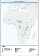
Wetlands, re-encoded from country separates of WRI-AFDS to a seamless continental derivative. The WTLND_PY shapefile data layer is comprised of 4404 derivative vector wetlands features derived based on 1:1 000 000 data originally from WCMC. The layer provides nominal analytical/mapping at 1:1 000 000. Acronyms and Abbreviations: WCMC - World Conservation Monitoring Centre; WRI - World Resources Institute; AFDS - African Data Sampler.
-
Enhanced SWB polygonal derivative based on 4 separate RWDB2 Library layers. The RWDB_SWB-PY shapefile data layer is comprised of 8750 derivative vector framework library features derived based on 1:3 000 000 data originally from RWDBII. The layer provides nominal analytical/mapping at 1:3 000 000. Data processing complete globally. Acronyms and Abbreviations: RWDB2 or RWDB II- Relational World Database II SWB - Surface Water Body