 FAO Map Catalog
sorghum
Type of resources
Available actions
Topics
Keywords
Contact for the resource
Provided by
Years
Formats
Representation types
Update frequencies
status
Scale
Resolution
-
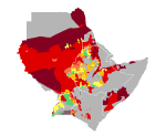
Sorghum yield in Djibouti, Eritrea, Ethiopia, Kenya, Somalia, Sudan and Uganda. Map presents reference yield estimated through data collection and agricultural statistics.
-
The suitability analysis allowed identifying a suitability weight to each crop, based on the climate conditions (ClimAfrica) outputs as well as on the soil quality. Both climate and soil classes have been combined in order to produce one suitability map for each crop and each 30-year period (historical, current, and the 3 future periods). This dataset has been produced in the framework of the “Climate change predictions in Sub-Saharan Africa: impacts and adaptations (ClimAfrica)” project, Work Package 4 (WP4). More information on ClimAfrica project is provided in the Supplemental Information section of this metadata.