 FAO Map Catalog
length of growing period
Type of resources
Available actions
Topics
Keywords
Contact for the resource
Provided by
Years
Formats
Representation types
Update frequencies
status
Resolution
-
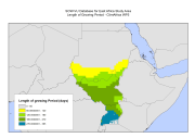
The Length of Growing Period (LGP) refers to the average duration when moisture availability allows crop growth. The calculation is based on a water balance model that compares moisture supply from precipitation, soil moisture storage and a reference evapotranspiration. The reference LGP assumes available soil moisture capacity of 100 mm per meter soil depth and a reference soil depth of one meter. LGP's were based on the baseline period of 1961-1990. This dataset has been used to complement the survey data and included in the "Climate change predictions in Sub-Saharan Africa: impacts and adaptations (ClimAfrica)" project, Work Package 5 (WP5). More information on ClimAfrica project is provided in the Supplemental Information section of this metadata. This study in WP5 aimed to identify, locate and characterize groups that are vulnerable for climate change conditions in two country clusters; one in West Africa (Benin, Burkina Faso, Côte d'Ivoire, Ghana, and Togo) and one in East Africa (Sudan, South Sudan and Uganda). Data used for the study include the Demographic and Health Surveys (DHS) , the Multi Indicator Cluster Survey (MICS) and the Afrobarometer surveys for the socio-economic variables and grid level data on agro-ecological and climatic conditions.
-
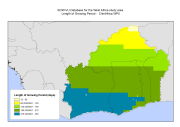
The Length of Growing Period (LGP) refers to the average duration when moisture availability allows crop growth. The calculation is based on a water balance model that compares moisture supply from precipitation, soil moisture storage and a reference evapotranspiration. The reference LGP assumes available soil moisture capacity of 100 mm per meter soil depth and a reference soil depth of one meter. LGP's were based on the baseline period of 1961-1990. This dataset has been used to complement the survey data and included in the "Climate change predictions in Sub-Saharan Africa: impacts and adaptations (ClimAfrica)" project, Work Package 5 (WP5). More information on ClimAfrica project is provided in the Supplemental Information section of this metadata. This study in WP5 aimed to identify, locate and characterize groups that are vulnerable for climate change conditions in two country clusters; one in West Africa (Benin, Burkina Faso, Côte d'Ivoire, Ghana, and Togo) and one in East Africa (Sudan, South Sudan and Uganda). Data used for the study include the Demographic and Health Surveys (DHS) , the Multi Indicator Cluster Survey (MICS) and the Afrobarometer surveys for the socio-economic variables and grid level data on agro-ecological and climatic conditions.
-
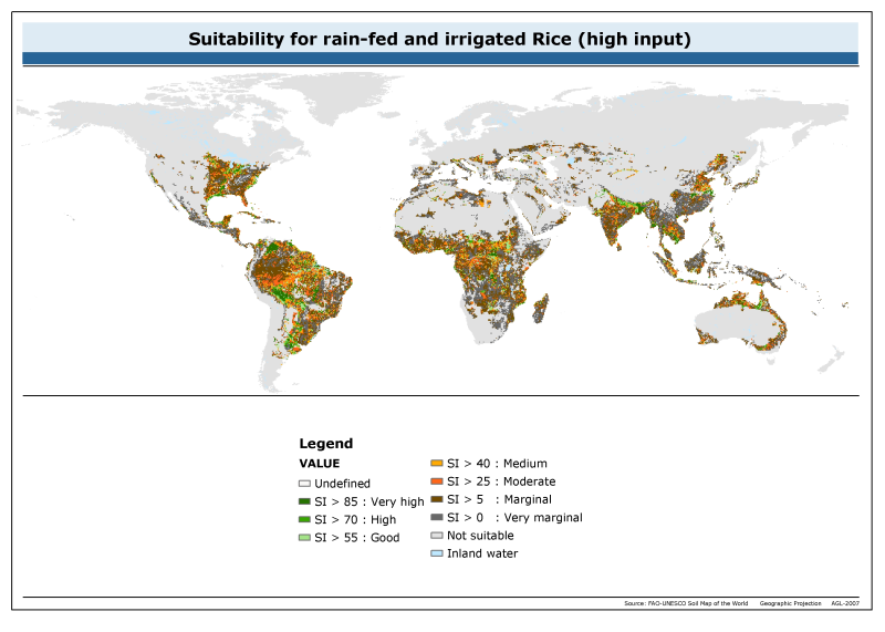
The raster dataset of suitability for rainfed and irrigated rice with high input has a spatial resolution of 5 * 5 arc minutes and is in geographic projection. Information with regard to rice suitability was obtained from the "Derived Soil Properties" of the FAO-UNESCO Soil Map of the World which contains raster information on soil properties.