 FAO Map Catalog
irrigated areas
Type of resources
Available actions
Topics
Keywords
Contact for the resource
Provided by
Years
Formats
Representation types
Update frequencies
status
-

Global Map of Irrigation Areas - Version 5 Grid with percentage of area equipped for irrigation with a spatial resolution of 5 arc minutes or 0.083333 decimal degrees. This dataset is developed in the framework of the AQUASTAT Programme of the Land and Water Division of the Food and Agriculture Organization of the United Nations and the Rheinische Friedrich-Wilhems University, Germany. The map shows the amount of area equipped for irrigation around the year 2005 in percentage of the total area on a raster with a resolution of 5 minutes. Additional map layers show the percentage of the area equipped for irrigation that was actually used for irrigation and the percentages of the area equipped for irrigation that was irrigated with groundwater, surface water or non-conventional sources of water. In details, the following products have been released and made available for download: (A) Area equipped for irrigation expressed as percentage of total area: total=aei, surface water=aeisw, groundwater=aeigw, non-conventional sources of water=aeinc (ASCII-grid); (B) Area actually irrigated expressed as percentage of area equipped for irrigation (ASCII-grid); (C) Area equipped for irrigation expressed in hectares per cell (ASCII-grid); (D) Irrigated areas v.5 (ESRI shapefile); (E) High and low resolution images (PDF); (F) Quality Assessment (Excel) Due to the map generation method, the quality of the map can never be uniform. The overall quality of the map depends heavily on the individual quality of the data for the different countries.
-
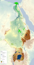
This map shows the Geographic Information System (GIS) ancillary information used to prepare thematic posters for the FAO-Nile Basin project. They are: -administrative units; -basin boundary; -boundary above water bodies; -country boundaries; canals&tunnels; -cities; -irrigated areas; -protected areas; -rivers; urban areas; -water bodies; -SRTM. Sources and information for each layer can be found in the "FAO Nile Information Products Synthesis Report" here available in the Distribution section of this metadata form.