 FAO Map Catalog
hillshade
Type of resources
Available actions
Topics
Keywords
Contact for the resource
Provided by
Years
Representation types
Update frequencies
status
Scale
-
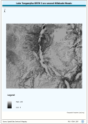
Lake Tanganyika SRTM 3 as Hillshade Mosaic. The HSHD_MOS grid data layer is comprised of 14401x16801 derivative raster hillshade features derived based on 0.000833_ data originally from SRTM. The layer provides nominal analytical/mapping at 1:250 000. Acronyms and Abbreviations: DEM - Digital Elevation Model
-
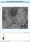
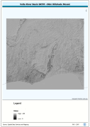
Seamless DEM (Digital Elevation Model) covering Lake Tanganyika Basin-Watershed. The LKTAN_HSHD image data layer is comprised of 14401x16801 derivative raster hillshade features derived based on 0.000833_ data originally from SRTM.
-
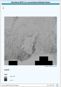
Volta Basin SRTM 3 as Based Hillshade Mosaic. SRTM is Shuttle Radar Topography Mission. The HSHD_MOS grid data layer is comprised of 13201x14401 derivative raster hillshade features derived based on 0.000833_ data originally from SRTM 3as v.2.
-
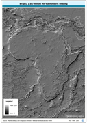
ETOPO2 2 arc-minute Hill-Bathymetric Shading. ETOPO2 is a 2 minute Elevation Topographic DEM including bathymetry. The ETOPO2_HSHD grid data layer is comprised of 5400x10800 derivative raster hillshade | bathymetry features derived based on 0.03333_ data originally from ETOPO2. The layer provides nominal analytical/mapping at 1:12 500 000. Acronyms and Abbreviations: ETOPO2 - A 2 minute Elevation Topographic DEM including bathymetry; DEM - Digital Elevation Model.
-
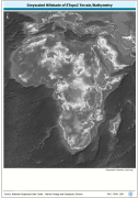
Grayscale hillshaded image of SRTM 3 as terrestrial DEM and ETopo2 bathymetric data, resampled for compatibility with HydroShed data for Africa. SRTM is Shuttle Radar Topography Mission; DEM is Digital Elevation Model; ETopo2 is a 2 minute Elevation Topographic DEM including bathymetry. The 7-5AS_GSCL_SRTM-BATH image data layer is comprised of 37221x45583 derivative image hillshade features derived based on 0.0020833333_ data originally from SRTM 3as v.2.
-
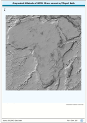
Grayscale hillshaded image of SRTM-30 terrestrial DEM and ETopo2 bathymetric data; SRTM is Shuttle Radar Topography Mission; DEM is Digital Elevation Model; ETopo2 is a 2 minute Elevation Topographic DEM including bathymetry. The SRTM30_HSHD image data layer is comprised of 9600x9600 derivative raster hillshade features derived based on 0.00833_ data originally from SRTM 30as v.2.
-

Grayscale of ETM+ based natural-color image mosaic baseline enhanced with 2.5d.. The ETM_MOSAIC_HSHD image data layer is comprised of 18899x19509 derivative image hillshade features derived based on 465 metre data originally from ETM+ Browse.
-
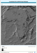
Grid based hillshade of consolidated 30 as SRTM-ETopo2 DEM. SRTM is Shuttle Radar Topography Mission; DEM is Digital Elevation Model; ETOPO2 is a 2 minute Elevation Topographic DEM including bathymetry.. The HSHDBATH grid data layer is comprised of 10800x11400 derivative raster hillshade features derived based on 0.00833_ data originally from SRTM 30as v.2.
-
Seamless nominal 90 metre DEM (Digital Elevation Model) of Volta Megabasin. The VOLTA_HSHD image data layer is comprised of 13201x14401 derivative raster hillshade features derived based on 0.000833_ data originally from SRTM 3as v.2.
-
Grayscale image of nominal 3.7 Km bathymetry and terrestrial elevation values. The ETOPO2_SHD image data layer is comprised of 5400x10800 derivative raster hillshade | bathymetry features derived based on 0.03333_ data originally from ETOPO2.