 FAO Map Catalog
global database
Type of resources
Available actions
Topics
Keywords
Contact for the resource
Provided by
Formats
Representation types
Update frequencies
status
Scale
-

This dataset is a raster format GeoTIFF representing the percentage of density in each pixel of snow and glaciers. It is part of the Global Land Cover-SHARE (GLC-SHARE) database at the global level created by FAO, Land and Water Division in partnership and with contribution from various partners and institutions.
-
This dataset is a raster format GeoTIFF representing the percentage of density in each pixel of the herbaceous vegetation coverage. It is part of the Global Land Cover-SHARE (GLC-SHARE) database at the global level created by FAO, Land and Water Division in partnership and with contribution from various partners and institutions.
-

This dataset is a raster format GeoTIFF representing the percentage of density coverage in each pixel of the land cover type. It is part of the Global Land Cover-SHARE (GLC-SHARE) database at the global level created by FAO, Land and Water Division in partnership and with contribution from various partners and institutions.
-

This dataset is a raster format GeoTIFF representing the percentage of density in each pixel of sparse vegetation. It includes any geographic areas were the cover of natural vegetation is between 2% and 10%, including permanently or regularly flooded areas. Sparse vegetation dataset is part of the Global Land Cover-SHARE (GLC-SHARE) database at the global level created by FAO, Land and Water Division in partnership and with contribution from various partners and institutions.
-
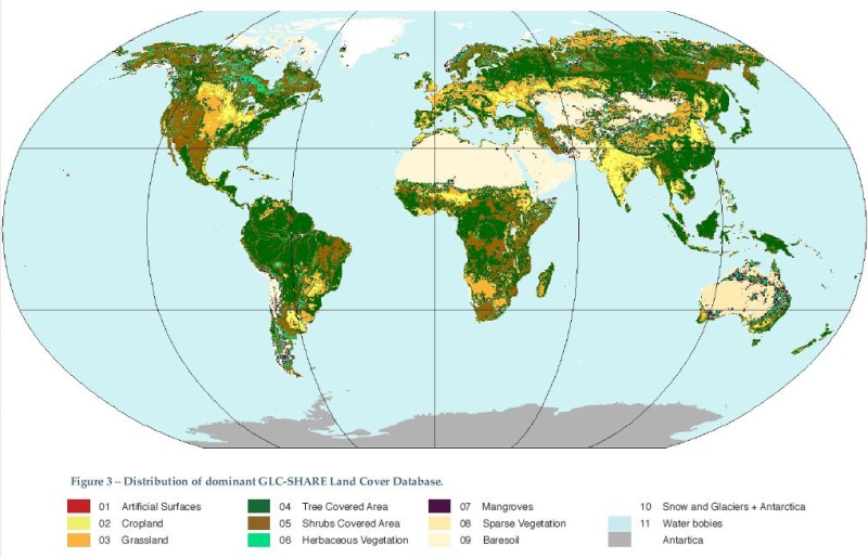
The Global Land Cover-SHARE (GLC-SHARE) is a new land cover database at the global level created by FAO, Land and Water Division in partnership and with contribution from various partners and institutions. It provides a set of major thematic land cover layers resulting by a combination of "best available" high resolution national, regional and/or sub-national land cover databases with the weighted average land cover information derived from large-scale available datasets. The database is produced with a resolution of 30 arc second (1km). The approach implemented is based on the utilization of the Land Cover Classification System (LCCS) and SEEA (System of Environmental-Economic Accounting) legend systems for the harmonization of the various global, regional and national land cover legends. The major benefit of the GLC-SHARE product is its capacity to preserve the existing and available high resolution land cover information at the regional and country level obtained by spatial and multi-temporal source data, integrating them with the best synthesis of global datasets. Preliminary validation campaign was performed using 1000 random points statistically distributed over each land cover classes. The database is distributed in the following eleven layers, in raster format (GeoTIFF ), whose pixel values represent the percentage of density coverage in each pixel of the land cover type. The dominant layer, representing the value of the dominant land cover type, is also available along with a legend in LYR ESRI format. Finally, information on each layer's source is retrievable in sources layer, by joining the raster values with an Excel table. 01-Artificial Surfaces 02-CropLand 03-Grassland 04-Tree Covered Area 05-Shrubs Covered Area 06-Herbaceous vegetation, aquatic or regularly flooded 07-Mangroves 08-Sparse vegetation 09-BareSoil 10-Snow and glaciers 11-Waterbodies
-

This dataset is a raster format GeoTIFF representing the percentage of density in each pixel of the trees coverage. It is part of the Global Land Cover-SHARE (GLC-SHARE) database at the global level created by FAO, Land and Water Division in partnership and with contribution from various partners and institutions.
-

This dataset is a raster format GeoTIFF representing the percentage of density in each pixel of the shrubs coverage. It is part of the Global Land Cover-SHARE (GLC-SHARE) database at the global level created by FAO, Land and Water Division in partnership and with contribution from various partners and institutions.
-
The Global Land Cover-SHARE (GLC-SHARE) is a new land cover database at the global level created by FAO, Land and Water Division in partnership and with contribution from various partners and institutions. It provides a set of major thematic land cover layers resulting by a combination of "best available" high resolution national, regional and/or sub-national land cover databases with the weighted average land cover information derived from large-scale available datasets. The database is produced with a resolution of 30 arc second (1km). The approach implemented is based on the utilization of the Land Cover Classification System (LCCS) and SEEA (System of Environmental-Economic Accounting) legend systems for the harmonization of the various global, regional and national land cover legends. The major benefit of the GLC-SHARE product is its capacity to preserve the existing and available high resolution land cover information at the regional and country level obtained by spatial and multi-temporal source data, integrating them with the best synthesis of global datasets. Preliminary validation campaign was performed using 1000 random points statistically distributed over each land cover classes. The database is distributed in the following eleven layers, in raster format (GeoTIFF ), whose pixel values represent the percentage of density coverage in each pixel of the land cover type. The dominant layer, representing the value of the dominant land cover type, is also available along with a legend in LYR ESRI format. Finally, information on each layer's source is retrievable in sources layer, by joining the raster values with an Excel table. 01-Artificial Surfaces 02-CropLand 03-Grassland 04-Tree Covered Area 05-Shrubs Covered Area 06-Herbaceous vegetation, aquatic or regularly flooded 07-Mangroves 08-Sparse vegetation 09-BareSoil 10-Snow and glaciers 11-Waterbodies
-

This dataset is a raster format GeoTIFF representing the percentage of density in each pixel of the mangroves coverage. It is part of the Global Land Cover-SHARE (GLC-SHARE) database at the global level created by FAO, Land and Water Division in partnership and with contribution from various partners and institutions.