 FAO Map Catalog
evapotranspiration
Type of resources
Available actions
Topics
Keywords
Contact for the resource
Provided by
Years
Formats
Representation types
Update frequencies
status
Scale
Resolution
-
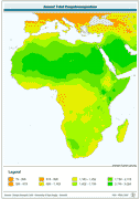
Annual Total Evapotranspiration. The ET_YR grid data layer is comprised of 1080x2160 derivative raster evapotranspiration features derived based on 0.167 degrees resolution data originally from CRU. The layer provides nominal analytical/mapping at 1:70 000 000. Monthly evapotranspiration from January to December is also available for download. Acronyms and Abbreviations: CRU - Climatic Research Unit - School of Environmental Sciences, University of East Anglia - Norwich.
-
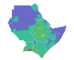
Average annual Potential Evapotranspiration (PET) in Djibouti, Eritrea, Ethiopia, Kenya, Somalia, Sudan and Uganda.
-
The Food and Agriculture Organization of the United Nations (FAO) with the collaboration of the International Institute for Applied Systems Analysis (IIASA), has developed a system that enables rational land-use planning on the basis of an inventory of land resources and evaluation of biophysical limitations and potentials. This is referred to as the Agro-ecological Zones (AEZ) methodology.
-
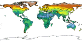
Aridity index (P/Pet) derived from IDRISI file with continuous data, reclassified into 6 classes (+ water bodies); The 6th class indicates cold climate derived from Thermal climates (Boreal and Arctic) received from IIASA in 2002. The IDRISI file with Aridity values was received by IIASA on February 2003.
-
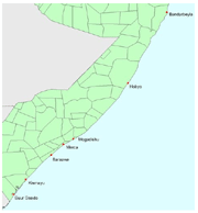
The images provide detailed rainfed crop calendar information for coastal areas in Somalia affected by the Tsunami, for the following stations: Bandarbeyla, Hobyo, Merca, Baraawe, Mogadishu, Kismayu, Buur gaado.
-
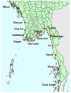
The images provide detailed rainfed crop calendar information for coastal areas in Myanmar affected by the Tsunami, for the following stations: Mergui, Dawei, Moulmein, Sittwe, Talok babai, Ye, Yangon, Kyaikpi, Kala-ywa, Dawnyein, Wagon, Hnathabu, Wet-the, Mawyon.
-
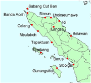
The images provide detailed rainfed crop calendar information for coastal areas in Indonesia affected by the Tsunami, for the following stations: Sabang cut ban, Sibolga, Banda aceh, Calang, Meulaboh, Tapaktuan, Barus, Bireun, Lhokseumawe, Idi, Langsa, Belawan, Sinabang, Gunungsitoli
-
The images provide detailed rainfed crop calendar information for coastal areas in Bangladesh affected by the Tsunami, for the following stations: Cox's bazaar, Chittagong, Noakhali, Munshir hat.
-
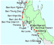
The images provide detailed rainfed crop calendar information for coastal areas in Thailand affected by the Tsunami, for the following stations: Phuket, Ranong, Krabi, Thalang, Ban tha chat chai, Ban lam ru, Ban khao ba, Ban thung dap, Ban kam phuam, Ban hua hin, Ko lanta, Ban hua thanon, Kantang, Palian, Ban chemilang.
-
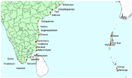
The images provide detailed rainfed crop calendar information for coastal areas in India affected by the Tsunami, for the following stations: Vishakhapatnam, Kakinda, Nellore, Cuddalore, Trivandrum, Port blair, Srikakulam, Tuni, Kottapatnam, Dugarajupatnam, Chennai, Pondicherry, Karaikal, Vederanniyam, Rameswaram, Kilakarai, Tuticorin Kolachel, Quilon, Manglutan, Karen, Tafwap, Bananga.