 FAO Map Catalog
environmental constraints
Type of resources
Available actions
Topics
Keywords
Contact for the resource
Provided by
Representation types
Update frequencies
status
-
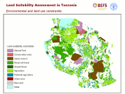
This map identifies areas that in Tanzania could not be available for bioenergy activities due to diverse constraints. In particular it shows the land already under agriculture production, protected or environmentally sensitive areas, urban settlements and bare land that have been excluded from the BEFS land suitability assessment of Tanzania, in order to get a true understanding of which lands are available for bioenergy production in this country. Data sources: FAO Africover (1995-2002), UNEP-WCMC and IUCN, 2008. All BEFS results have been reported in the FAO publication "Bioenergy and Food Security - The BEFS Analysis for Tanzania" and the final products made available in this catalogue.
-
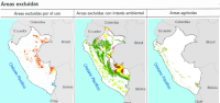
The environmental and land use constraints identify areas that in Peru could not be available for bioenergy activities due to diverse reasons. They show the land already under agriculture production, protected or environmentally sensitive areas, urban settlements etc. that have been excluded from the BEFS land suitability assessment of Peru, in order to get a true understanding of which lands are available for bioenergy production in this country. In particular the following maps of constraints have been identified: 1) "Excluded areas" map, which includes not available areas due to restrictions by national legislation, like: i) water bodies and rivers (information extracted from IGN), lakes (extracted Map Forest-INRENA 2000); ii) forest concessions and chestnuts concessions (INRENA-concessions obtained by public-contest); iii) reservoir, mountains and village (taken from the Forest Map). 2) "Areas of environmental concern" map which includes areas where it is not possible to intervene by national law restrictions or different environmental protection mechanisms. It contains the following information: (i) protected forest (Map Forestal INRENA 2000); (Ii) protected areas for reforestation (Map Reforestation-INRENA 2000); (Iii) protected areas and areas complementary, native communities (National System of Protected Areas-SINANPE), (iv) territorial reserve (surface in favor of indigenous peoples living in isolation INRENA), (v) swamps, wetlands and mangroves (land cover map-INRENA 2000). 3) "Agricultural areas" map which identify areas with potential conflict between bioenergy and food production. The information in agricultural areas is taken from Forest-mining Category map crop farming- (Forest Map of INRENA 2000). All BEFS results have been reported in the FAO publication “Bioenergía y seguridad alimentaria - El análisis de BEFS para el Perú - Compendio técnico Vol I y II†and the final products made available in this catalogue.