 FAO Map Catalog
elevation
Type of resources
Available actions
Topics
Keywords
Contact for the resource
Provided by
Years
Representation types
Update frequencies
status
Scale
-
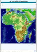
A Shaded relief image based on the first globally available elevation model. The AFRICA_BACKGROUND image data layer is comprised of 973x985 derivative raster bathymetry and elevation features derived based on 0.08333_ data originally from ETOPO5.
-

RGB color image of nominal 3.7 Km bathymetry and terrestrial elevation values. RGB is 3 band spatial imagery forced into the Red:Green:Blue spectrum. The ETOPO2_RGB image data layer is comprised of 5400x10800 derivative raster bathymetry features derived based on 0.03333_ data originally from ETOPO2.
-
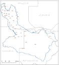
Elevation points in meters within the Okavango Basin. Source: Generated under the GIS EPSMO program, by vectorization of existing topographic maps at 1/1 000 000. This dataset is part of the GIS Database for the Environment Protection and Sustainable Management of the Okavango River Basin project (EPSMO). Detailed information on the database can be found in the “GIS Database for the EPSMO Project†document produced by Luis Veríssimo (FAO consultant) in July 2009, and here available for download.
-
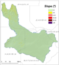
This raster layer represents the slope model within the Okavango Basin. Source: Data generated under the GIS EPSMO program (base:OB_DTM). This dataset is part of the GIS Database for the Environment Protection and Sustainable Management of the Okavango River Basin project (EPSMO). Detailed information on the database can be found in the “GIS Database for the EPSMO Project†document produced by Luis Veríssimo (FAO consultant) in July 2009, and here available for download.
-
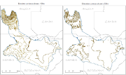
A set of 2 vector layers representing the contour lines at every 100m and 200m within the Okavango Basin. Source: Contour 100m generated under the GIS EPSMO program, by interpolation of the DTM model, and further operations of smoothing tolerance. Contour 200m generated under the GIS EPSMO program, by vectorization of existing topographic maps at 1/1 000 000. This dataset is part of the GIS Database for the Environment Protection and Sustainable Management of the Okavango River Basin project (EPSMO). Detailed information on the database can be found in the “GIS Database for the EPSMO Project†document produced by Luis Veríssimo (FAO consultant) in July 2009, and here available for download.
-
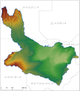
Digital Terrain Model within the Okavango Basin. Source: Data generated under the GIS EPSMO program (base:SRTM data). This dataset is part of the GIS Database for the Environment Protection and Sustainable Management of the Okavango River Basin project (EPSMO). Detailed information on the database can be found in the “GIS Database for the EPSMO Project†document produced by Luis Veríssimo (FAO consultant) in July 2009, and here available for download.
-
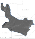
This raster layer represents the hill shade model within the Okavango Basin. Source: Data generated under the GIS EPSMO program (base:OB_DTM). This dataset is part of the GIS Database for the Environment Protection and Sustainable Management of the Okavango River Basin project (EPSMO). Detailed information on the database can be found in the “GIS Database for the EPSMO Project†document produced by Luis Veríssimo (FAO consultant) in July 2009, and here available for download.
-

This raster layer is the hill shade in the CORB-contributing area, in the reference scale of 1/200 000. It was created by interpolation of the DTM model with 90m pixel resolution. This dataset is part of the GIS Database for the Environment Protection and Sustainable Management of the Okavango River Basin project (EPSMO). Detailed information on the database can be found in the “GIS Database for the EPSMO Project†document produced by Luis Veríssimo (FAO consultant) in July 2009, and here available for download.