 FAO Map Catalog
cropland
Type of resources
Available actions
Topics
Keywords
Contact for the resource
Provided by
Formats
Representation types
Update frequencies
status
-
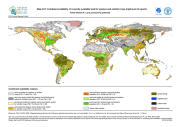
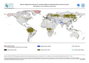
The FGGD combined suitability maps at low, intermediate and high levels of inputs under rainfed conditions on currently available land are global raster datalayers with a resolution of 5 arc-minutes. Pixels classified as urban, closed forest or irrigated contain negative values. Each remaining pixel contains a combined suitability class value for rainfed agriculture, based on the 2005 version of the suitability indexes for rainfed production of all crops plus pasture. The method is described in FAO and IIASA, 2007, Mapping biophysical factors that influence agricultural production and rural vulnerability, by H. von Velthuizen et al.
-
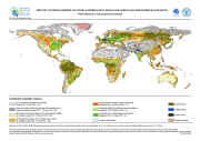
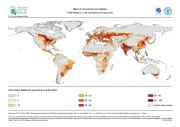
The FGGD land cover occurrence maps are global raster datalayers with a resolution of 5 arc-minutes. Each pixel in each map contains a value representing the percentage of the area belonging to the land cover type concerned. The method is described in FAO and IIASA, 2007, Mapping biophysical factors that influence agricultural production and rural vulnerability, by H. von Velthuizen et al.
-

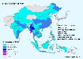
This raster dataset provides information on crop types and their spatial extent in Afghanistan. 2 classes are considered: cropland and non cropland
-

The FGGD irrigated areas map is a global raster datalayer with a resolution of 5 arc-minutes. Each pixel in the map contains a value representing the percentage of the area equipped for irrigation. The data are a IIASA modification of FAO and University of Kessel (2002), Digital Global Map of Irrigated Areas v. 2.1. Please for the latest version refer to www.fao.org/ag/agl/aglw/aquastat/irrigationmap/index10.stm
-
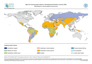
The FGGD farming system classes map is a global raster datalayer with a resolution of 5 arc-minutes. Each pixel is classified as belonging to one of seven farming system classes, aggregated from the original 45 farming systems contained in the farming systems map. The data are taken from regional maps generated for inclusion in FAO and World Bank, 2001, Farming systems and poverty, by J. Dixon et al.
-
The FGGD currently available land map by land cover type is a global raster datalayer with a resolution of 5 arc-minutes. Each pixel is classified as urban, closed forest, irrigated or other land, that is considered available for rainfed agriculture. The method is described in FAO and IIASA, 2007, Mapping biophysical factors that influence agricultural production and rural vulnerability, by H. von Velthuizen et al.
-

The FGGD total currently available land map is a global raster datalayer with a resolution of 5 arc-minutes. Pixels classified as urban, closed forest, or irrigated are indicated as land not currently available for rainfed agriculture. All remaining pixels classified as other land represent land currently available for rainfed agriculture. The method is described in FAO and IIASA, 2007, Mapping biophysical factors that influence agricultural production and rural vulnerability, by H. von Velthuizen et al.
-
Agro-MAPS consists of selected agricultural land-use statistics (crop production, area harvested and crop yield) aggregated by sub-national administrative districts for selected years. The full Agro-MAPS database currently contains data for 134 countries - 130 countries at admin1 level; 59 countries at admin2 level. These countries represent 92% of the world land surface. Users can interactively query and display Agro-MAPS data as maps, for a given country or region (Africa, Asia, North America, Latin America & the Caribbean, Asia, Near East in Asia, Oceania).