 FAO Map Catalog
carbon cycle
Type of resources
Topics
Keywords
Contact for the resource
Provided by
Formats
Representation types
Update frequencies
status
Resolution
-
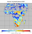
Dataset with information on fractions of different crop types /CFTs at different land cover fractions based on the Synergetic Land Cover Product (SYNMAP), at global scale and for the African continent. SYNMAP is an improved global land cover product with 48 classes at 1-km spatial resolution, reflecting global land covers around year 2000. It fuses different global land cover products, including, Global Land Cover Characterization Database (GLCC), GLC2000, and the 2001 MODIS land cover product, based on fuzzy agreement, which highlights individual strengths and weaknesses of mapping approaches. The overall advantage of the SYNMAP legend is that all classes are properly defined in terms of plant functional types mixtures, which can be remotely sensed and include the definitions of leaf type and longevity for each class with a tree component. This data set has been produced in the framework of the "Climate change predictions in Sub-Saharan Africa: impacts and adaptations (ClimAfrica)" project, Work Package 1 (WP1). WP1 (Past climate variability) aimed to provide consolidated data to other WPs in ClimAfrica, and to analyze the interactions between climate variability, water availability and ecosystem productivity of Sub-Saharan Africa. Various data streams that diagnose the variability of the climate, in particular the water cycle, and the productivity of ecosystems in the past decades, have been collected, analyzed and synthesized. The data streams range from ground-based observations and satellite remote sensing to model simulations. More information on ClimAfrica project is provided in the Supplemental Information section of this metadata.
-
The Multipurpose Africover Database for the Environmental Resources is a digital georeferenced database on land cover and a geographic referential for the whole of Africa including: - geodetical homogeneous referential - toponomy - roads - hydrography It is produced at a 1:200,000 scale (1:100,000 for small countries and specific areas). Reinforcing national and sub-regional capacities for the establishment update and use of the geographic referential and land cover maps and spatial data bases is the core strategy of the Africover project: this has been the methodology adopted to ensure an operational approach and the sustainability of the initiative.