 FAO Map Catalog
Zimbabwe
Type of resources
Available actions
Topics
Keywords
Contact for the resource
Provided by
Formats
Representation types
Update frequencies
status
Scale
-

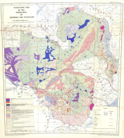
Provisional soil map of Southern Rhodesia
-
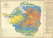
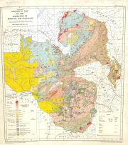
Vegetation map of the Federation of Rhodesia and Nyasaland
-

Provisional Soil Map of Southern Rhodesia and the Tati Concession (3 000 000)
-
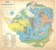
Exploratory soil map of Rhodesia
-
Provisional soil map of Zimbabwe Rhodesia (ed. 2)
-
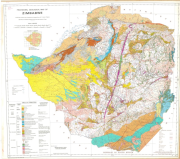
(7th edition, reprinted 1991)
-
Provisional geological map of the Federation of Rhodesia and Nyasaland
-

This layer represents the country boundaries of the 4 riparian countries that share geographical overlapping with the Okavango Basin: Angola, Namibia, Botswana and Zimbabwe. Source: Digital Chart of the World (DCW) with further editing corrections for a more accurate spatial definition. This dataset is part of the GIS Database for the Environment Protection and Sustainable Management of the Okavango River Basin project (EPSMO). Detailed information on the GIS Database can be found in the “GIS Database for the EPSMO Project†document produced by Luis Veríssimo (FAO consultant) in July 2009, and here available for download.
-
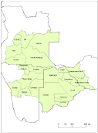
This layer represents the political regional boundaries (level of Province, Region and District) in the 4 riparian countries that share geographical overlapping with the Okavango Basin: Angola, Namibia, Botswana and Zimbabwe. Source: Digital Chart of the World (DCW) with further editing corrections for a more accurate spatial definition. This dataset is part of the GIS Database for the Environment Protection and Sustainable Management of the Okavango River Basin project (EPSMO). Detailed information on the GIS Database can be found in the “GIS Database for the EPSMO Project†document produced by Luis Veríssimo (FAO consultant) in July 2009, and here available for download.
-

This layer represents the political administration level 1 boundaries (level of municipality, (Region) and subdistrict) in the 4 riparian countries, that share geographical overlapping with the Okavango Basin: Angola, Namibia, Botswana and Zimbabwe. Source: Generated under the GIS EPSMO program. This dataset is part of the GIS Database for the Environment Protection and Sustainable Management of the Okavango River Basin project (EPSMO). Detailed information on the GIS Database can be found in the “GIS Database for the EPSMO Project†document produced by Luis Veríssimo (FAO consultant) in July 2009, and here available for download.