 FAO Map Catalog
Water balance
Type of resources
Available actions
Topics
Keywords
Contact for the resource
Provided by
Representation types
Update frequencies
status
-

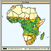
Spatial distribution of net annual water loss from ponds through evaporation and seepage. The water balance for fishponds was calculated by estimating the deficit between precipitation and combined evaporation plus seepage. Evaporation was calculated using the Hargreaves formula (i.e. mean monthly minimum and maximum air temperature data were provided by FAO) and seepage was a constant.
-

Montly water requirement for fish ponds during the dry season. Water requirement was computed using a water budget equation for each grid cell. The equation is based on the difference amongst precipitation, potential evapotranspiration and seepage. Mean monthly gridded values for precipitation were obtained from the Centre for Resource and Environmental Studies (CRES) at the Australian National University. GRID files containing monthly potential evapotranspiration values according to Penman-Monteith method for the whole world were obtained from the International Institute for Applied Systems Analysis (IIASA). Seepage was a coefficient in the water budget equation.
-
Total amount of water required for fishponds during the dry season. This net annual water requirement was computed using a water budget equation for each grid cell. The equation is based on the difference amongst precipitation, potential evapotranspiration and seepage and these calculations were derived from monthly evaluations. Mean monthly gridded values for precipitation were obtained from the Centre for Resource and Environmental Studies (CRES) at the Australian National University. GRID files containing monthly potential evapotranspiration values according to Penman-Monteith method for the whole world were obtained from the International Institute for Applied Systems Analysis (IIASA). Seepage was a coefficient in the water budget equation.
-
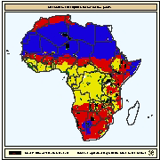
Spatial distribution of water availability for fish ponds. Map derived from the combined suitability of annual rainfall with density of perennial streams and rivers. Annual rainfall interpreted as rainfall runoff to fill fishponds. Mean annual precipitation data for Africa were obtained from UNEP/GRID in Nairobi and was developed for the Global Assessment of Soil Degradation (GLASOD) using data from 1951-1980. A digital map of perennial streams and rivers was generated by ESRI (1984).