 FAO Map Catalog
Wastes
Type of resources
Available actions
Topics
Keywords
Contact for the resource
Provided by
Representation types
Update frequencies
status
-
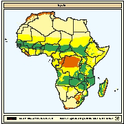
Productivity and variety of crops interpreted as availability of agricultural by products as inputs for fish farming. The objective of this map is to indicate the locations, availability and variety of agricultural by-products that could be used as inputs for fish farming. These can be related to agronomic suitability as measured by the length of growing period (LGP). Agro-ecological zones for 11 crops were defined for Africa by FAO (1978). LGP was calculated from data collected from 730 stations and plotted at 30-day intervals at 1:5 million scale.
-

Areas with potential availability of agricultural by products for use as feeds or fertilizer inputs. It is based on soil productivity and length of growing period (LGP). Two geo-referenced datasets provided the basic material for the evaluation: the FAO/UNESCO Soil Map of the World and an inventory of climate regimes to characterize length of the growing period (LGP).
-
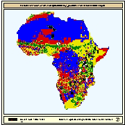
Areas in which livestock wastes and supplementary food such as agricultural by-products could contribute to the establishment of pond culture systems such as integrated agriculture-aquaculture farming. Livestock population was used as a surrogate for manure. Livestock populations for cattle, goats, sheep and pigs in the form of animal/km2 were obtained from U.S. Army CERL and CRSSA, Cook College, Rutgers University. Data on crops were derived from the Global Land Cover Characteristics database. To consider the combined suitability of livestock wastes and crops it was considered that livestock manure was more important compared to crops because African small-scale fish farmers usually employ manure and by-products are used only as a supplement.