 FAO Map Catalog
WP1
Type of resources
Available actions
Topics
Keywords
Contact for the resource
Provided by
Formats
Representation types
Update frequencies
status
Resolution
-
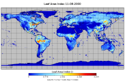
A consistent gapfilled 16 daily Leaf Area Index dataset at half degree spatial resolution based on the original LAI dataset retrieved with the Joint Research Centre Two-stream Inversion Package (JRC-TIP). Aggregation is based on weighted mean of valid 0.01 degree original LAI_TIP pixels. This data set has been produced in the framework of the "Climate change predictions in Sub-Saharan Africa: impacts and adaptations (ClimAfrica)" project, Work Package 1 (WP1). WP1 (Past climate variability) aimed to provide consolidated data to other WPs in ClimAfrica, and to analyze the interactions between climate variability, water availability and ecosystem productivity of Sub-Saharan Africa. Various data streams that diagnose the variability of the climate, in particular the water cycle, and the productivity of ecosystems in the past decades, have been collected, analyzed and synthesized. The data streams range from ground-based observations and satellite remote sensing to model simulations. More information on ClimAfrica project is provided in the Supplemental Information section of this metadata.
-
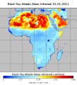
The dataset represents different MODIS Albedo's based on MCD43C3 Albedo 8-Day L3, for the African continent at 8 daily 0.5 degree spatial resolution. The resulting data set is based on the average aof all valid 0.05 degree grid cells within a half degree grid cell. List of Albedos: BSA_nir_Albedo/ [Black Sky Albedo (Near-Infrared)] BSA_shortwave_Albedo/ [Black Sky Albedo (shortwave)] BSA_vis_Albedo/ [Black Sky Albedo (visible)] WSA_nir_Albedo/ [White Sky Albedo (Near-Infrared)] WSA_shortwave_Albedo/ [White Sky Albedo (shortwave)] WSA_vis_Albedo/ [White Sky Albedo (White Sky Albedo (Visible)isible)] This data set has been produced in the framework of the "Climate change predictions in Sub-Saharan Africa: impacts and adaptations (ClimAfrica)" project, Work Package 1 (WP1). WP1 (Past climate variability) aimed to provide consolidated data to other WPs in ClimAfrica, and to analyze the interactions between climate variability, water availability and ecosystem productivity of Sub-Saharan Africa. Various data streams that diagnose the variability of the climate, in particular the water cycle, and the productivity of ecosystems in the past decades, have been collected, analyzed and synthesized. The data streams range from ground-based observations and satellite remote sensing to model simulations. More information on ClimAfrica project is provided in the Supplemental Information section of this metadata.
-

The dataset represents spatially aggregated soil properties from the Harmonized World Soil Database v110, 0.5 degree spatial resolution. Contact the data publisher for detailed description of the aggregation method. Selected soil properties: AWC; AWC_Class; S_Clay; S_OC; S_Silt; S_Gravel; S_Sand; S_USDA_TEX; T_Clay; T_OC; T_Silt; T_Clay; T_OC; T_Silt; T_Gravel; T_Sand; T_USDA_TEX. This data set has been produced in the framework of the "Climate change predictions in Sub-Saharan Africa: impacts and adaptations (ClimAfrica)" project, Work Package 1 (WP1). WP1 (Past climate variability) aimed to provide consolidated data to other WPs in ClimAfrica, and to analyze the interactions between climate variability, water availability and ecosystem productivity of Sub-Saharan Africa. Various data streams that diagnose the variability of the climate, in particular the water cycle, and the productivity of ecosystems in the past decades, have been collected, analyzed and synthesized. The data streams range from ground-based observations and satellite remote sensing to model simulations. More information on ClimAfrica project is provided in the Supplemental Information section of this metadata.
-
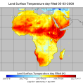
The dataset covers Land Surface Temperature (Day and Night) based on the MOD11C2 climate modelling grid (CMG). The resulting product is the average of all 0.05 degree grid cells, within a 0.5 degree grid cell. This data set has been produced in the framework of the "Climate change predictions in Sub-Saharan Africa: impacts and adaptations (ClimAfrica)" project, Work Package 1 (WP1). WP1 (Past climate variability) aimed to provide consolidated data to other WPs in ClimAfrica, and to analyze the interactions between climate variability, water availability and ecosystem productivity of Sub-Saharan Africa. Various data streams that diagnose the variability of the climate, in particular the water cycle, and the productivity of ecosystems in the past decades, have been collected, analyzed and synthesized. The data streams range from ground-based observations and satellite remote sensing to model simulations. More information on ClimAfrica project is provided in the Supplemental Information section of this metadata.
-

A global daily database of satellite soil moisture based on harmonizing multiple passive (SSMR, SSM/I, TRMM, AMSRE, WINDSAT) and active (ERS, MATOP) satellite products. This data set has been produced in the framework of the "Climate change predictions in Sub-Saharan Africa: impacts and adaptations (ClimAfrica)" project, Work Package 1 (WP1). WP1 (Past climate variability) aimed to provide consolidated data to other WPs in ClimAfrica, and to analyze the interactions between climate variability, water availability and ecosystem productivity of Sub-Saharan Africa. Various data streams that diagnose the variability of the climate, in particular the water cycle, and the productivity of ecosystems in the past decades, have been collected, analyzed and synthesized. The data streams range from ground-based observations and satellite remote sensing to model simulations. More information on ClimAfrica project is provided in the Supplemental Information section of this metadata.
-

A consistent and harmonized product of satellite observed fraction of absorbed photosynthetically active radiation (FAPAR). FAPAR is a biophysical variable that indicates the state and health of the vegetation. This data set provides monthly FAPAR from 1982 until 2010 at global scale and for the African continent. The construction of the data set made use of existing products from AVHRR, SeaWiFS and MERIS satellite sensors. This data set has been produced in the framework of the "Climate change predictions in Sub-Saharan Africa: impacts and adaptations (ClimAfrica)" project, Work Package 1 (WP1). WP1 (Past climate variability) aimed to provide consolidated data to other WPs in ClimAfrica, and to analyze the interactions between climate variability, water availability and ecosystem productivity of Sub-Saharan Africa. Various data streams that diagnose the variability of the climate, in particular the water cycle, and the productivity of ecosystems in the past decades, have been collected, analyzed and synthesized. The data streams range from ground-based observations and satellite remote sensing to model simulations. More information on ClimAfrica project is provided in the Supplemental Information section of this metadata.
-

The datasets represent monthly Sensible and Latent Heat Flux at 0.5 degree spatial resolution from 1982 - 2010 over the African continent. For a detailed description of the data sets see: Jung, M. et all. (2011) Global patterns of land-atmosphere fluxes of carbon dioxide, latent heat, and sensible heat derived from eddy covariance, satellite, and meteorological observations. Journal of Geophysical Research - Biogeosciences, 116, doi:10.1029/2010JG001566. request by email. This data set has been produced in the framework of the "Climate change predictions in Sub-Saharan Africa: impacts and adaptations (ClimAfrica)" project, Work Package 1 (WP1). WP1 (Past climate variability) aimed to provide consolidated data to other WPs in ClimAfrica, and to analyze the interactions between climate variability, water availability and ecosystem productivity of Sub-Saharan Africa. Various data streams that diagnose the variability of the climate, in particular the water cycle, and the productivity of ecosystems in the past decades, have been collected, analyzed and synthesized. The data streams range from ground-based observations and satellite remote sensing to model simulations. More information on ClimAfrica project is provided in the Supplemental Information section of this metadata.
-
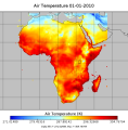
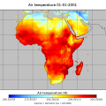
Bias Correction of ERA-interim meteorological forcing dataset for Africa, based on Piani et al. (2010) for the period 1979 - 2011. Variables description Tair: air temperature (K) Tmin: minimum air temperature (K) Tmax: maximum air temperature (K) PSurf: surface pressure (Pa) Qmean: specific humidity (kg/kg) Wind: wind speed (m/s) Precip: precipitation (mm) LWdown: Downwards long-wave radiation flux (W/m-2) SWdown: Downwards short-wave radiation flux (W/m-2). This data set has been produced in the framework of the "Climate change predictions in Sub-Saharan Africa: impacts and adaptations (ClimAfrica)" project, Work Package 1 (WP1). WP1 (Past climate variability) aimed to provide consolidated data to other WPs in ClimAfrica, and to analyze the interactions between climate variability, water availability and ecosystem productivity of Sub-Saharan Africa. Various data streams that diagnose the variability of the climate, in particular the water cycle, and the productivity of ecosystems in the past decades, have been collected, analyzed and synthesized. The data streams range from ground-based observations and satellite remote sensing to model simulations. More information on ClimAfrica project is provided in the Supplemental Information section of this metadata.
-
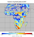
Dataset with information on fractions of different crop types /CFTs at different land cover fractions based on the Synergetic Land Cover Product (SYNMAP), at global scale and for the African continent. SYNMAP is an improved global land cover product with 48 classes at 1-km spatial resolution, reflecting global land covers around year 2000. It fuses different global land cover products, including, Global Land Cover Characterization Database (GLCC), GLC2000, and the 2001 MODIS land cover product, based on fuzzy agreement, which highlights individual strengths and weaknesses of mapping approaches. The overall advantage of the SYNMAP legend is that all classes are properly defined in terms of plant functional types mixtures, which can be remotely sensed and include the definitions of leaf type and longevity for each class with a tree component. This data set has been produced in the framework of the "Climate change predictions in Sub-Saharan Africa: impacts and adaptations (ClimAfrica)" project, Work Package 1 (WP1). WP1 (Past climate variability) aimed to provide consolidated data to other WPs in ClimAfrica, and to analyze the interactions between climate variability, water availability and ecosystem productivity of Sub-Saharan Africa. Various data streams that diagnose the variability of the climate, in particular the water cycle, and the productivity of ecosystems in the past decades, have been collected, analyzed and synthesized. The data streams range from ground-based observations and satellite remote sensing to model simulations. More information on ClimAfrica project is provided in the Supplemental Information section of this metadata.
-
WATCH Forcing Data 20th Century. A meteorological forcing dataset (based on ERA-40) for land surface and hydrological models (1901-2001). Data generated in 2 tranches with slightly different methodology: 1901-1957 and 1958-2001. Five variables are at 6 hourly resolution and five variables are at 3 hourly resolution: Tair_WFD_ - 2m Air temperature (K) Tmin_WFD_ - 2m Minimum air temperature (K) Tmax_WFD_ - 2m Maximum air temperature (K) PSurf_WFD_ - 10m Surface pressure (Pa) Qair_WFD_ - 2m Specific umidity (kg/kg) Wind_WFD_ - 10m Wind speed (m/s) LWdown_WFD_ - Downwards long-wave radiation flux (W/m-2) SWdown_WFD_ - Downwards short-wave radiation flux (W/m-2) Rainf_WFD_GPCC_ - Rainfall rate GPCC bias corrected and undercatch corrected Snowf_WFD_GPCC_ - Snowfall rate GPCC bias corrected and undercatch corrected (kg/m-2/s) Rainf_WFD_CRU_ - Rainfall rate CRU bias corrected and undercatch corrected (kg/m-2/s) Snowf_WFD_CRU_ - Snowfall rate CRU bias corrected and undercatch corrected (kg/m-2/s). This data set has been produced in the framework of the "Climate change predictions in Sub-Saharan Africa: impacts and adaptations (ClimAfrica)" project, Work Package 1 (WP1). WP1 (Past climate variability) aimed to provide consolidated data to other WPs in ClimAfrica, and to analyze the interactions between climate variability, water availability and ecosystem productivity of Sub-Saharan Africa. Various data streams that diagnose the variability of the climate, in particular the water cycle, and the productivity of ecosystems in the past decades, have been collected, analyzed and synthesized. The data streams range from ground-based observations and satellite remote sensing to model simulations. More information on ClimAfrica project is provided in the Supplemental Information section of this metadata.