 FAO Map Catalog
Volta
Type of resources
Available actions
Topics
Keywords
Contact for the resource
Provided by
Years
Representation types
Update frequencies
status
Scale
-
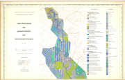
Carte pédologique des bassins versants des voltas rouge et blanche; (Soil Map)
-
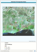
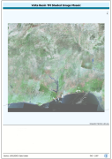
Enhanced natural color orthorectified image baseline, reprojected and mosiaced into single coverage of a Megabasin. Source: NASA Landsat Orthorectified MSS, TM and ETM+. The VOLTA_TM-RGB image data layer is comprised of 42465x46324 derivative image satellite based imagery features derived based on 28.5 metre data originally from TM.
-
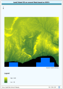
Volta Basin SRTM 3 as Based DEM Mosaic. SRTM is Shuttle Radar Topography Mission; DEM is Digital Elevation Model. The DEM_MOS grid data layer is comprised of 13201x14401 derivative raster digital elevation model features derived based on 0.000833_ data originally from SRTM 3as v.2.
-
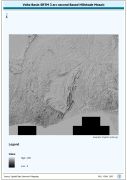
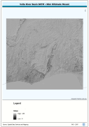
Volta Basin SRTM 3 as Based Hillshade Mosaic. SRTM is Shuttle Radar Topography Mission. The HSHD_MOS grid data layer is comprised of 13201x14401 derivative raster hillshade features derived based on 0.000833_ data originally from SRTM 3as v.2.
-
Enhanced natural color and 2.5d hillshade orthorectified image derivative, reprojected and mosaiced into single coverage of a Megabasin. Source: NASA Landsat Orthorectified MSS, TM and ETM+. The VOLTA_TM-SHD image data layer is comprised of 42465x46324 derivative image satellite based imagery features derived based on 28.5 metre data originally from TM.
-
Seamless nominal 90 metre DEM (Digital Elevation Model) of Volta Megabasin. The VOLTA_HSHD image data layer is comprised of 13201x14401 derivative raster hillshade features derived based on 0.000833_ data originally from SRTM 3as v.2.