 FAO Map Catalog
Togo
Type of resources
Available actions
Topics
Keywords
Contact for the resource
Provided by
Years
Formats
Representation types
Update frequencies
status
Scale
Resolution
-

Include: Carte des aptitudes culturales des sols, productivit� actuelle - Carte des aptitudes des sols, productivit� potentielle
-

Carte écologique basée sur les images Landsat
-
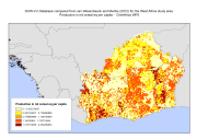
SOW-VU "Africa in maps" database updated from van Wesenbeeck and Merbis, 2012. These include population maps (total, urban, rural, refugees/IDPs), food aid distribution, and estimates of total production measured in mt cereal equivalents per capita. This data set have been used to complement the survey data and included in the "Climate change predictions in Sub-Saharan Africa: impacts and adaptations (ClimAfrica)" project, Work Package 5 (WP5). More information on ClimAfrica project is provided in the Supplemental Information section of this metadata. The study in WP5 aimed to identify, locate and characterize groups that are vulnerable for climate change conditions in two country clusters; one in West Africa (Benin, Burkina Faso, Côte d'Ivoire, Ghana, and Togo) and one in East Africa (Sudan, South Sudan and Uganda). Data used for the study include the Demographic and Health Surveys (DHS) , the Multi Indicator Cluster Survey (MICS) and the Afrobarometer surveys for the socio-economic variables and grid level data on agro-ecological and climatic conditions.
-
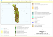
This land cover data set is derived from the original raster based Globcover regional (Africa) archive. It has been post-processed to generate a vector version at national extent with the LCCS regional legend (46 classes). This database can be analyzed in the GLCN software Advanced Database Gateway (ADG), which provides a user-friendly interface and advanced functionalities to breakdown the LCCS classes in their classifiers for further aggregations and analysis. The data set is intended for free public access. The shape file's attributes contain the following fields: -Area (sqm) -ID -Gridcode (Globcover cell value) -LCCCode (unique LCCS code) You can download a zip archive containing: -the shape file (.shp) -the ArcGis layer file with global legend (.lyr) -the ArcView 3 legend file (.avl) -the LCCS legend tables (.xls)
-
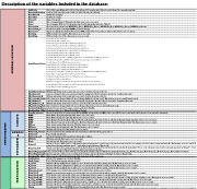
The database includes a set of field collected biophysical parameters in a wide range of Sub-Saharan African agroecosystems. The main parameters include: · Current and past land use category, with approximate date of change (if any); · Main climatic parameters, obtained from the closest weather station; · Type of underlying bedrock; · A set of topographical variables: altitude, slope, aspect, macrotopography and microtopography; · General fertilization information (if any); · General grazing management (if any); · General crop management (sown species, rotation, irrigation, etc.); · Soil data (including texture, bulk density, C, N, P, pH, CEC, etc); · Vegetation biomass; · Vascular species richness. Sampling plots and boundaries of study areas are available as digital maps in the "Distribution" section of this metadata. This set of data has been produced in the framework of the "Climate change predictions in Sub-Saharan Africa: impacts and adaptations (ClimAfrica)" project, Work Package 6 (WP6). For more information on the following work packages produced, please contact the data originator indicated in the Point of contacts section of this metadata. • Project Deliverable D6.1 - Catalogue of selected watersheds for the case studies. • Project Deliverable D6.2 - Reports on site characteristics of the model areas using a standardized format. • Project Deliverable D6.3 - Database of relevant eddy covariance measurements from the available CarboAfrica (FP6 project) flux sites to be delivered to WP1 and WP2 for model development. • Project Deliverable D6.4 - High spatial and temporal resolution time series combining high and medium spatial resolution satellite data for assimilation and phenological modelling.
-

The dataset includes a set of socio-economic field collected data in a wide range of Sub-Saharan African communities. The main parameters include: · Historical climate events (description of main climatic events described by the surveyed communities); · Mental models (conceptual understanding of climate change as perceived by local communities); · Participatory risk mapping (main risks/hazards to livelihood perceived by local communities); · Stakeholders analysis (identification of institutional structures that come into force under environmental stress); · Household demographics; · General household livelihood portfolio; · Household vulnerability mapping (identification of main stressors at household level); This set of data has been produced in the framework of the "Climate change predictions in Sub-Saharan Africa: impacts and adaptations (ClimAfrica)" project, Work Package 6 (WP6). For more information on the following work packages produced, please contact the data originator indicated in the Point of contacts section of this metadata. • Project Deliverable D6.1 - Catalogue of selected watersheds for the case studies. • Project Deliverable D6.2 - Reports on site characteristics of the model areas using a standardized format. • Project Deliverable D6.3 - Database of relevant eddy covariance measurements from the available CarboAfrica (FP6 project) flux sites to be delivered to WP1 and WP2 for model development. • Project Deliverable D6.4 - High spatial and temporal resolution time series combining high and medium spatial resolution satellite data for assimilation and phenological modelling.
-
Etc and yield reduction for major crops in case study areas of Burkina, Malawi, Kenya, Sudan, Togo and Ghana (1980-2100). Input Parameters for Climate: daily Minimum and Maximum Temperature, Precipitation and solar radiation. Input Parameters for Soil: Texture, Depth, Drainage, Slope, pH, Organic content, Ece, EXP. Input Sources for Climate: 3 GCMs (MIROC5, CanESM2 and NOAA-GFDL) statistically downscaled (SOMDS) by UCT and dynamically downscaled (SMHI-RCM) from CORDEX experiment at 0.5°, RCP 8.5. Input Sources for Soil: information from WP6 and from HWSD. This data set has been produced in the framework of the "Climate change predictions in Sub-Saharan Africa: impacts and adaptations (ClimAfrica)" project, Work Package 3 (WP3). WP3 aimed at quantifying the sensitivity of vegetation productivity and water resources to seasonal, inter-annual and decadal variability in weather and climate, using impact models on agriculture and water. The available models in combination with developed datasets of land use and climate from WP2 were used to simulate crop yield and water resources. Simulations using short-term scenarios of future climate change (5-10 years) were used to identify regional differences in the climate sensitivity of crop production etc. Scenarios for the African agricultural/pastoral sectors were also made using longer model runs. Finally, tradeoffs and areas of risk and vulnerability were identified in relation to: - Water-related hazards; - Agricultural and pastoral performance; - Soil degradation. More information on ClimAfrica project is provided in the Supplemental Information section of this metadata.
-
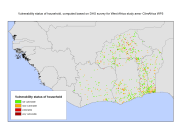
Vulnerability status of households in West Africa, computed based on DHS data. This dataset has been produced in the framework of the "Climate change predictions in Sub-Saharan Africa: impacts and adaptations (ClimAfrica)" Project, Work Package 5 (WP5). More information on ClimAfrica project is provided in the Supplemental Information section of this metadata. This study in WP5 aimed to identify, locate and characterize groups that are vulnerable for climate change conditions in two country clusters; one in West Africa (Benin, Burkina Faso, Côte d'Ivoire, Ghana, and Togo) and one in East Africa (Sudan, South Sudan and Uganda). Data used for the study include the Demographic and Health Surveys (DHS) , the Multi Indicator Cluster Survey (MICS) and the Afrobarometer surveys for the socio-economic variables and grid level data on agro-ecological and climatic conditions.
-
Maturity and Yield for major crops in case study areas of Burkina, Malawi, Kenya, Sudan, Togo and Ghana (1980-2100), under rainfed and irrigated conditions (constant and transient CO2). Input Parameters for Climate: daily Minimum and Maximum Temperature, Precipitation and solar radiation. Input Parameters for Soil: Texture, Depth, Drainage, Slope, pH, Organic content, Ece, EXP. Input Sources for Climate: 3 GCMs (MIROC5, CanESM2 and NOAA-GFDL) statistically downscaled (SOMDS) by UCT and dynamically downscaled (SMHI-RCM) from CORDEX experiment at 0.5°, RCP 8.5. Input Sources for Soil: information from WP6 and from HWSD. This data set has been produced in the framework of the "Climate change predictions in Sub-Saharan Africa: impacts and adaptations (ClimAfrica)" project, Work Package 3 (WP3). WP3 aimed at quantifying the sensitivity of vegetation productivity and water resources to seasonal, inter-annual and decadal variability in weather and climate, using impact models on agriculture and water. The available models in combination with developed datasets of land use and climate from WP2 were used to simulate crop yield and water resources. Simulations using short-term scenarios of future climate change (5-10 years) were used to identify regional differences in the climate sensitivity of crop production etc. Scenarios for the African agricultural/pastoral sectors were also made using longer model runs. Finally, tradeoffs and areas of risk and vulnerability were identified in relation to: - Water-related hazards; - Agricultural and pastoral performance; - Soil degradation. More information on ClimAfrica project is provided in the Supplemental Information section of this metadata.
-
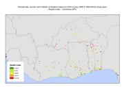
Households, women and children indicators based on data from the DHS surveys in Benin (2001), Burkina Faso (2003), Cote D'Ivoire (1999), Ghana (2008) and Togo (1998). The following indicators have been considered to create raster datasets at 5 arcmin resolution: wealth index, age and sex of the head of household, number of dependent household members (under the age of 5), educational attainment of the respondent, occupation of the respondent, current employment status of the respondent, type and duration employment of the respondent, payment received for work by the respondent, number of sons and daughters away from home, number of years the respondent lived in the current residence, religion of the respondent. This data set has been produced in the framework of the "Climate change predictions in Sub-Saharan Africa: impacts and adaptations (ClimAfrica)" project, Work Package 5 (WP5). More information on ClimAfrica project is provided in the Supplemental Information section of this metadata. This study in WP5 aimed to identify, locate and characterize groups that are vulnerable for climate change conditions in two country clusters; one in West Africa (Benin, Burkina Faso, Côte d'Ivoire, Ghana, and Togo) and one in East Africa (Sudan, South Sudan and Uganda). Data used for the study include the Demographic and Health Surveys (DHS) , the Multi Indicator Cluster Survey (MICS) and the Afrobarometer surveys for the socio-economic variables and grid level data on agro-ecological and climatic conditions.