 FAO Map Catalog
Tanganyika
Type of resources
Available actions
Topics
Keywords
Contact for the resource
Provided by
Years
Representation types
Update frequencies
status
Scale
-
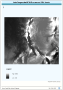
Lake Tanganyika SRTM 3 as DEM Mosaic. The DEM_MOS grid data layer is comprised of 14401x16801 derivative raster digital elevation model features derived based on 0.000833_ data originally from SRTM. The layer provides nominal analytical/mapping at 1:250 000. Acronyms and Abbreviations: SRTM - Shuttle Radar Topography Mission DEM - Digital Elevation Model
-
Enhanced natural color and 2.5d hillshade orthorectified image derivative. The LKTAN_IMGCAT_IMGSHD image data layer is comprised of 120 derivative calculated seamless image catalog features derived based on 15 metre data originally from FAO.
-
Enhanced natural color orthorectified image baseline. The LKTAN_IMGCAT_IMG image data layer is comprised of 120 derivative calculated seamless image catalog features derived based on 28 metre data originally from FAO.
-
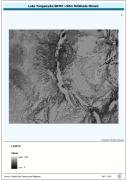
Seamless DEM (Digital Elevation Model) covering Lake Tanganyika Basin-Watershed. The LKTAN_HSHD image data layer is comprised of 14401x16801 derivative raster hillshade features derived based on 0.000833_ data originally from SRTM.
-
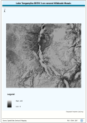
Lake Tanganyika SRTM 3 as Hillshade Mosaic. The HSHD_MOS grid data layer is comprised of 14401x16801 derivative raster hillshade features derived based on 0.000833_ data originally from SRTM. The layer provides nominal analytical/mapping at 1:250 000. Acronyms and Abbreviations: DEM - Digital Elevation Model