 FAO Map Catalog
Tag_landcover
Type of resources
Available actions
Topics
Keywords
Contact for the resource
Provided by
Years
Formats
Representation types
Update frequencies
status
Scale
Resolution
-

High-resolution, multi-purpose land cover products are available for a few countries only worldwide. The Africover Eastern Africa module (AFRICOVER) of the Global Land Cover Network (GLCN) initiative (www.glcn.org) produced detailed land cover maps for ten countries in Eastern Africa. The land cover database was created based on the visual on-screen interpretation of Landsat imagery in combination with in-situ validation data and expert knowledge. The land cover database includes the following ten countries: Burundi, Democratic Republic of Congo, Egypt, Eritrea, Kenya, Rwanda, Somalia, Sudan, United Republic of Tanzania and Uganda (FAO 1998). The Landsat images used for mapping were acquired between 1995 and 2001 and have been interpreted at a scale of 1:200,000 or 1:100,000 respectively for large or small countries. The legend used in AFRICOVER products is based on the Land Cover Classification System (LCCS). The full-resolution versions of the 10 datasets were used as input to derive circa 1-km grids of crop percentages. Land cover classes were first analysed at the level of polygon by using LCCS definitions, thereby deriving the minimum, maximum and mean crop percentage for each polygon. A ‘best estimate’ of crop percentage, normally but not always corresponding to the mean, was also established. Results were subsequently rasterized to an intermediate 100m-resolution product and finally aggregated to 1km resolution map. All types of crops are considered, including herbaceous, shrub and tree crops. A comparable product has been generated from the 2005 land cover of Senegal (GLCN, 2005)(Cropland extent in Senegal).
-

This land cover database has been produced after the Ketsana Typhoon that hit Laos in September 28, 2009. Land cover monitoring and assessment is essential for the sustainable management of natural resources, environmental protection, food security, and of course for measuring the impact and extent of natural disasters. Commissioned by the Lao FAOREP, the GIS and RS group of the FAO NR Department has conducted a quick interpretation of historical satellite imagery (Landsat ETM from the Global Land Survey archive), dated around 2000, according to procedures, methodologies and tools established by the Global Land Cover Network (GLCN) programme. The LCCS approach was adopted to classify the land cover.
-
This land cover data set is derived from the original raster based Globcover global archive. It has been post-processed to generate a vector version at national extent with the LCCS legend (22 classes worldwide) for being analyzed in the GLCN software Advanced Database Gateway (ADG). ADG software provides a user-friendly interface and advanced functionalities to breakdown the LCCS classes in their classifiers for further aggregations and analysis. The data set is intended for free public access. The shape file's attributes contain the following fields: -Area (sqm) -Perimeter (m) -ID -Gridcode (Globcover cell value) -LCCCode (unique LCCS code) You can download a zip archive containing: -the shape file (.shp) -the ArcGis layer file with global legend (.lyr) -the ArcView 3 legend file (.avl) -the LCCS legend table (.xls)
-

This land cover data set is derived from the original raster based Globcover global archive, post-processed to generate a vector version at national extent and apply the LCCS legend (22 classes worldwide) for being analyzed in the GLCN software Advanced Database Gateway (ADG). ADG software provides a user-friendly interface and advanced functionalities to breakdown the LCCS classes in their classifiers for further aggregations and analysis. The data set is intended for free public access. The shape file's attributes contain the following fields: -Area (sqm) -Perimeter (m) -ID -Gridcode (Globcover cell value) -LCCCode (unique LCCS code) You can download a zip archive containing: -the shape file (.shp) -the ArcGis layer file with global legend (.lyr) -the ArcView 3 legend file (.avl) -the LCCS legend table (.xls)
-
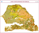
The land cover has been produced from visual interpretation of digitally enhanced LANDSAT ETM images (Bands 4,3,2) acquired mainly in the year 2000-2005. The land cover classes have been developed using the FAO/UNEP international standard LCCS classification system. The land cover legend of Senegal, consisting of 55 classes, was set up using the F.A.O. LCCS methodology. To affine the interpretation, a set of aerial photos donated by USGS and the high resolution images of Google Earth have been used. The mapping scale used for the visual photo-interpretation was 1:100.000. The full resolution version of the Land Cover dataset consists of 23,922 polygons, covering an area of 19,659 thousands ha. There is also an aggregated version generated on the basis of a spatial criteria, which produces about the 11% reduction of the total amount of polygons. The spatially aggregated dataset (available for download) consists of 21,238 polygons. The Senegal Land Cover mapping was carried out in the framework of Global Land Cover Network (GLCN) activities.
-

This data set is a re-aggregated version of the full resolution Libyan land cover database. The original full resolution data has been concentrated in few generalized classes highlighting the most relevant features mapped without loosing information. The result is an aggregation of 10 generalized classes listed below, which keeps a good level of information, giving at the same time an exact estimation of the areas covered by each aggregated class. The 10 Generalized Classes aggregation Land Cover map of Libya: AGRICULTURE AI - Irrigated Agriculture AR - Rainfed Agriculture NATURAL VEGETATION NF - Natural Forest and Reforestations NV - Rangeland BARE AREAS BC - Bare Soil Consolidated BU - Bare Soil Unconsolidated BSn - Loose and Shifting Sand BW - Bare Soil in Wadi Environment SABKHAS SK - Terrestrial and Aquatic Sabkha Environment and Waterbodies URBAN AREAS UB - Urban areas, Quarries and Dump Sites The land cover products were developed by FAO as part of the LIB/00/04 'Mapping of Natural Resources for Agriculture Use and Planning Project in Libya'. This project was initiated by the Government of Libya, FAO and the United Nations Development Programme (UNDP) to strengthen the capacity of the General People's Committee for Agriculture, Animal and Marine Wealth (GAAAMW) to manage land resources at national and sub-national levels through the establishment of a strategy, and a spatially based operational decision support system - the Land Resources Information Management System (LRIMS).
-

This dataset is a raster format GeoTIFF representing the percentage of density in each pixel of water bodies. It is part of the Global Land Cover-SHARE (GLC-SHARE) database at the global level created by FAO, Land and Water Division in partnership and with contribution from various partners and institutions.
-

This land cover data set is derived from the original raster based Globcover global archive. It has been post-processed to generate a vector version at national extent with the LCCS legend (22 classes worldwide) for being analyzed in the GLCN software Advanced Database Gateway (ADG). ADG software provides a user-friendly interface and advanced functionalities to breakdown the LCCS classes in their classifiers for further aggregations and analysis. The data set is intended for free public access. The shape file's attributes contain the following fields: -Area (sqm) -Perimeter (m) -ID -Gridcode (Globcover cell value) -LCCCode (unique LCCS code) You can download a zip archive containing: -the shape file (.shp) -the ArcGis layer file with global legend (.lyr) -the ArcView 3 legend file (.avl) -the LCCS legend table (.xls)
-

This dataset has been produced from visual interpretation of digitally enhanced LANDSAT ETM images (Bands 4,3,2) acquired mainly in the year 2000-2005. The land cover classes have been developed using the FAO/UNEP international standard LCCS classification system. The land cover legend of Senegal, consisting of 55 classes, was set up using the F.A.O. LCCS methodology. To affine the interpretation, a set of aerial photos donated by USGS and the high resolution images of Google Earth have been used. The mapping scale used for the visual photo-interpretation was 1:100.000. The full resolution version of the Land Cover dataset consists of 23,922 polygons, covering an area of 19,659 thousands ha. There is also an aggregated version generated on the basis of a spatial criteria, which produces about the 11% reduction of the total amount of polygons. The spatially aggregated dataset (available for download) consists of 21,238 polygons. The Senegal Land Cover mapping was carried out in the framework of Global Land Cover Network (GLCN) activities.
-

The Jordanian land cover database and atlas were developed under the Regional Food Security Analysis Network (RFSAN) project. The Land Cover Atlas of the Hashemite Kingdom of Jordan provides information on the land cover distribution by subnational administrative boundaries (governorates and districts) shared by the Royal Jordanian Geographic Centre (RJGC). The main data source includes multispectral Sentinel-2 imagery at 10 m of spatial resolution acquired from April to November 2016 and ancillary georeferenced data (land cover and land use map, vegetation cover, soil map) obtained from different institutions. The Land cover database attributes contain the following fields: -Area (sqm) -ID -LCCSCode