 FAO Map Catalog
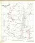
Swaziland
Type of resources
Available actions
Topics
Keywords
Contact for the resource
Provided by
Representation types
Update frequencies
status
Scale
-
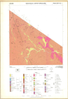
DOS-Geol. 1143
-
DOS-1216, Ed. 1, 2 & 3- Include: 2531 CC(1) - 2531 CD & Part of 2531 CB(2) - 2630 BD(10) - 2630 DB(16) - 2631 AA & part of 2630 BB (5) - 2631 AB(6) - 2631 AC(11) - 2631 BB(8) & part of 2531 DD(4) - 2631 CA(17) - 2631 CD(24) - 2632 AA & part of 2532 CC(9) - 2632 AC(15) - 2632 CA(21) - 2632 CC(27) - 2731 AA& part of 2730 BB(28) - 2731 AB & part of 2731 AD(29)
-
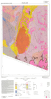
DOS Geol. 1089, 1st ed. Include: Sh. 2531 DC(3) - Sh.2630 DD(22) - Sh. 2631 CB(18) - Sh. 2631 CC(23) - Sh. 2631 DA(19)
-
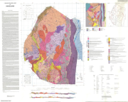
1:250 000 geological map of Swaziland (DOS 1230)
-
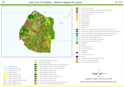
This land cover data set is derived from the original raster based Globcover regional (Africa) archive. It has been post-processed to generate a vector version at national extent with the LCCS regional legend (46 classes). This database can be analyzed in the GLCN software Advanced Database Gateway (ADG), which provides a user-friendly interface and advanced functionalities to breakdown the LCCS classes in their classifiers for further aggregations and analysis. The data set is intended for free public access. The shape file's attributes contain the following fields: -Area (sqm) -ID -Gridcode (Globcover cell value) -LCCCode (unique LCCS code) You can download a zip archive containing: -the shape file (.shp) -the ArcGis layer file with global legend (.lyr) -the ArcView 3 legend file (.avl) -the LCCS legend tables (.xls)