 FAO Map Catalog
Mariculture
Type of resources
Available actions
Topics
Keywords
Contact for the resource
Provided by
Years
Representation types
Update frequencies
status
-
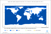
This dataset includes the regions with sea depths ranging from lower than 25 m, between 25-100 m and greater than 100 m.
-
Insert description of dataset
-
Insert description of dataset
-
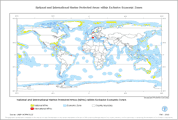
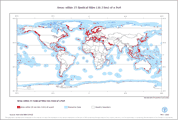
This polygon layer combines marine protected areas from the World Dataset of Protected Areas (UNEP-WCMW) and the Exclusive Economic Zones (VLIZ2009 - Flanders Marine Institute, Belgium) so that it reflects only marine portions of protected areas that have Exclusive Economic Zone attribute values. The dataset is also split into the following Geographic Zones: Arctic, Temperate, Intertemperate, Antarctic.
-
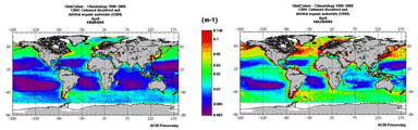
For the Global Ocean, climatology of the chlorophyll-a concentration for case 1 water (expressed in mg/m3). The climatology is based on the GlobColour (http://www.globcolour.info) products obtained by the merging of MERIS MODIS and SeaWIFS data available during the period 1998-2009. The "Minimum/Maximum" product represents for each pixel, the observed range of data when computing the chlorophyll-a concentration product by merging for each of the 12 years the selected month (April). The spatial resolution of the product is about 4km. The product has been designed and produced by ACRI-ST INFOCEAN-DESK environment monitoring service from EU FP7 & ESA MyOcean GlobColour Products, ESA ENVISAT MERIS data, NASA MODIS and SeaWiFS data. The GlobColour project has been initiated and funded by the ESA Data User Element Programme to develop a satellite based ocean colour data service to support global carbon-cycle research. The GlobColour project has largely benefited from NASA contributions, including the availability of the MODIS and SeaWiFS products; the in situ data base of radiometric and phytoplankton pigment data, and other oceanographic and atmospheric data: the SeaWiFS Bio-optical Archive and Storage System - SeaBASS (Werdell and Bailey, 2002). The global merged chlorophyll-a concentration for case 1 water is obtained by the merging of MERIS, MODIS and SeaWiFS data using an advanced retrieval based on fitting an in-water bio-optical model to the merged set of observed normalised water-leaving radiances (nLw?s). This technique is termed GSM because it originates from the Garver et al. (1997) bio-optical model (Maritorena and Siegel, 2005). More details are available at http://www.globcolour.info/CDR_Docs/GlobCOLOUR_PUG.pdf.
-
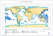
MEOW is a biogeographic classification of the world's coasts and shelves. It is the first ever comprehensive marine classification system with clearly defined boundaries and definitions and was developed to closely link to existing regional systems. The ecoregions nest within the broader biogeographic tiers of Realms and Provinces. MEOW represents broad-scale patterns of species and communities in the ocean, and was designed as a tool for planning conservation across a range of scales and assessing conservation efforts and gaps worldwide. The current system focuses on coast and shelf areas (as this is where the majority of human activity and conservation action is focused) and does not consider realms in pelagic or deep benthic environment. It is hoped that parallel but distinct systems for pelagic and deep benthic biotas will be devised in the near future. The project was led by The Nature Conservancy (TNC) and the World Wildlife Fund (WWF), with broad input from a working group representing key NGO, academic and intergovernmental conservation partners. The digital ecoregions layer is available for download as an ArcGIS Shapefile at http://conserveonline.org/workspaces/ecoregional.shapefile/MEOW/view.html.
-
This polygon layer reflects marine areas within 25 nautical miles travel distance of ports, combined by country, and split by depth range, economic zone and geographic zone. The dataset is derived from port points (World Port Index - NGA-USA), bathymetry data (GEBCO_08) and exclusive economic zones (VLIZ2009 - Flanders Marine Institute, Belgium).
-
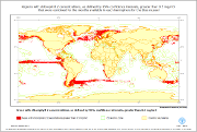
This dataset identifies all regions in which the full 95% confidence interval is greater than 0.5 mg/m3 that were combined for the months available in each hemisphere for the blue mussel. The chlorophyll 2 data includes the mean chlorophyll 2 level per month, the standard deviation and the number of observations used to calculate the mean. Based on these values, the 95% upper and lower confidence levels about the mean for each month have been generated.
-
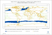
This dataset identifies all regions in which the full 95% confidence interval is between 4 and 16 �C for all 12 months. The sea surface temperature data includes the mean sea surface temperature per month, the standard deviation and the number of observations used to calculate the mean. Based on these values, the 95% upper and lower confidence levels about the mean for each month have been generated.
-
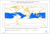
This dataset identifies all regions in which the full 95% confidence interval is between 22 and 32 �C for all 12 months. The sea surface temperature data includes the mean sea surface temperature per month, the standard deviation and the number of observations used to calculate the mean. Based on these values, the 95% upper and lower confidence levels about the mean for each month have been generated.