 FAO Map Catalog
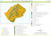
Lesotho
Type of resources
Available actions
Topics
Keywords
Contact for the resource
Provided by
Formats
Representation types
Update frequencies
status
Resolution
-

This raster dataset provides information on land cover in Lesotho. 15 classes are considered: Urban, Cropland, Degraded Cropland, Forest Needleleaf, Forest Broadleaf, Water body, Wetland, River Bank, Shrubland, Grassland, Degraded Grassland, Bare surfaces, Mines, Irrigated Cropland, Gullies.
-

The Lesotho Land Cover Database (LCDB) and ATLAS have been prepared in the framework of the FAO Emergency Program (OSRO/LES/401/EC): “Building Lesotho resilience through the upscale of Climate Smart Agriculture and functional DRR Land Resources Information”. The national Land Cover Legend was prepared using the FAO (ISO standard) Land Cover Classification System (LCCS): a FAO’s comprehensive, standardized “a priori” classification system, designed to meet specific user requirements and created for mapping exercises, independent of the scale or means used to map. The shape file's attributes contain the following fields: -ID -Area (km2) -LCS3Code (unique LCCS code) You can download a zip archive containing: -the shape file (.shp)
-
This land cover data set is derived from the original raster based Globcover regional (Africa) archive. It has been post-processed to generate a vector version at national extent with the LCCS regional legend (46 classes). This database can be analyzed in the GLCN software Advanced Database Gateway (ADG), which provides a user-friendly interface and advanced functionalities to breakdown the LCCS classes in their classifiers for further aggregations and analysis. The data set is intended for free public access. The shape file's attributes contain the following fields: -Area (sqm) -ID -Gridcode (Globcover cell value) -LCCCode (unique LCCS code) You can download a zip archive containing: -the shape file (.shp) -the ArcGis layer file with global legend (.lyr) -the ArcView 3 legend file (.avl) -the LCCS legend tables (.xls)