 FAO Map Catalog
Latin America and Caribbean
Type of resources
Available actions
Topics
Keywords
Contact for the resource
Provided by
Representation types
Update frequencies
status
Scale
Resolution
-
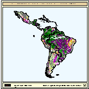
Map derived from the combined suitability of areas apt for small-scale fish farming development and operation with areas with potential yield (crops/y) of carp with a CFB of 0.075 kg/m3 and harvested at 150g. Suitable areas for small-scale fish farming were derived from the combined suitability of five land-quality factors important for fish farming development and operation; net annual water loss from ponds through evaporation and seepage; soil and terrain suitability for ponds; potential for agriculture by-products and fertiliser inputs; potential for farm gate sales; and potential market demand. Yield estimations for carp were based on water temperature which in turn were predicted from air temperature. Mean maximum and minimum monthly air temperatures grids were provide by FAO's Agrometeorology group. In order to explore a range of small-scale aquaculture possibilities by the use of the growth model, simulations were conducted for carp, assuming a harvesting weight of 150g. Natural food availability was modelled as a function of fish biomass and approach that requires definition of the critical standing crop (in kg/ha) or critical fish biomass (CFB; in kg/m3). For carp, ponds that are not heavily fertilized or fed, a CFB of about 0.075 kg/m3 (equivalent to a fish biomass of 750 kg/ha) was considered reasonable.
-

The major source of geo-referenced soil data of Latin America and the Caribbean at a scale of 1:5 M is the Soil Map of the World (SMW) of FAO/Unesco (1974-1981). For this part of the globe the information was collected before 1974, the year of publication of the Latin American map sheets. Collection of soil survey information by the national institutes responsible for soil survey continued after publication and a large amount of new data is available at the national level. Since 1991 the FAO is actualizing the SMW information of Latin America with support from national soils institutes in the concerned countries. This has resulted in the acquisition of new 1:5 M soil maps of most Latin American countries. New soil maps with a revised soil classification legend (FAO, 1990) of Argentina, Brazil, Chile, Colombia, Ecuador, Mexico, Paraguay, Peru, Uruguay and Venezuela were obtained by FAO through subcontracts with the national soil institutes. Since 1988 the World Soils and Terrain Database Programme (SOTER) is operational in various Latin American countries at a scale of 1:1 M, in particular in Argentina, Brazil and Uruguay with UNEP funding. The major objective of the SOTER methodology is to use information technology, like geographic information systems and database management systems, for the creation of a world soils and terrain database with digital maps and attributes and their interpretations. At the moment SOTER databases at scale 1:1 M are available for the whole of Uruguay, the northern part of Argentina (460,000 km2) and the south of Brazil (100,000 km2). In 1992 FAO formally endorsed SOTER and decided to use the methodology to store and update soils and terrain data at a global level. The SOTER Procedures Manual was published jointly by FAO, ISRIC, ISSS and UNEP in 1993 and in the following year also as No. 74 in the series of World Soil Resources Bulletins. During the same year an agreement was signed between FAO and UNEP to develop a soils and terrain database of Latin America at scale 1:5 M, jointly with the updating of the SMW. ISRIC was asked to coordinate the activities of the SOTERLAC 1:5 M project in the countries to be included.