 FAO Map Catalog
Hydrology
Type of resources
Available actions
Topics
Keywords
Contact for the resource
Provided by
Formats
Representation types
Update frequencies
status
Scale
-
The river network from National Statistical Office (NSO) from GeoBook published by University of PNG Remote Sensing Center is currently used. This is not river network but stream network developed from elevation data. When the original information is updated, the information displayed will be updated accordingly.
-
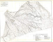
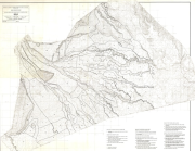
Climatological and hydrological maps of the Awash basin
-
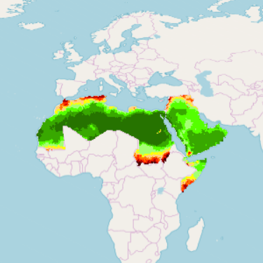
RICCAR, MENA Region - Vulnerability Assessment Exposure Indicators (HYPE RHM Output - Reference Period) This raster dataset provides a representation of the exposure indicators derived from hydrological model Hydrological Predictions for the Environment (HYPE) in the Middle East and North Africa Region, for the reference period 1986-2005. In the context of climate change, exposure refers to changes in climate parameters that might affect socio-ecological systems. Using on the open-source hydrological model HYPE and bias-corrected Regional Climate Models (RCM) results as inputs, the Regional Hydrological Model (RHM) ensemble is employed to assess hydrological change based on future climate projections. The RHM ensemble adopts the same time periods used by the Intergovernmental Panel for Climate Change (IPCC) and other regional climate modelling experiments. It runs climate simulations based on three future time periods that are compared with a historical reference period. Available at approximately 1km pixel resolution, for 1986-2005 reference period, the raster grids are generated for moderate and high representative concentration pathways (RCPs), emission scenarios developed by the IPCC for informing global and regional climate modelling work (RCP4.5 and RCP8.5). Grid pixel values are classified according to a level of exposure (1 to 10), for the indicators, Evapotranspiration and Runoff.
-

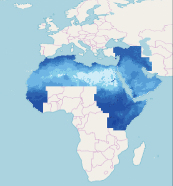
This raster dataset provides a representation of the change in Annual Runoff in the Middle East and North Africa Region. Bias-corrected Regional Climate Models (RCM) results serve as inputs for the generation of the Regional Hydrological Model (RHM) ensemble that uses the open-source hydrological model HYPE (Hydrological Predictions for the Environment). The RHM is applied to assess hydrological change using future climate projections and can accommodate large datasets spanning timescales exceeding 100 years. The RHM ensemble adopts the time periods used by the Intergovernmental Panel for Climate Change (IPCC) and other regional climate modelling experiments. It runs climate simulations based on three future time periods that are compared with a historical reference period. Available at 0,19 degree (approx. 21km) pixel resolution, for future time periods; Near, Mid and End-century, the raster grids are generated for moderate and high representative concentration pathways (RCPs), climate change scenarios developed by the IPCC for informing global and regional climate modelling work (RCP4.5 and RCP8.5). The adopted time periods are: Near-Century (2016-2035); Mid-Century (2046-2065); End-Century (2081-2100).
-
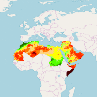
This raster dataset provides a representation of future levels of exposure for the indicators derived from hydrological model Variable Infiltration Capacity (VIC), in the Middle East and North Africa Region. In the context of climate change, exposure refers to changes in climate parameters that might affect socio-ecological systems. The Regional Hydrological Model (RHM) ensemble using on the open-source hydrological model VIC is applied to assess hydrological change based on future climate projections. Bias-corrected Regional Climate Models (RCM) results serve as inputs. The RHM adopts the time periods generally used by the Intergovernmental Panel for Climate Change (IPCC) and other regional climate modelling experiments. It runs climate simulations based on three future time periods that are compared with a historical reference period. Available at approximately 1km pixel resolution, for future time periods; Near, Mid and End-century, the raster grids are generated for moderate and high representative concentration pathways (RCPs), emission scenarios developed by the IPCC for informing global and regional climate modelling work (RCP4.5 and RCP8.5). Grid pixel values are classified according to a level of exposure (1 to 10), for the indicators, Evapotranspiration and Runoff. The adopted time periods are: Near-Century (2016-2035); Mid-Century (2046-2065); End-Century (2081-2100).
-

RICCAR, MENA Region - Vulnerability Assessment Exposure Indicators (HYPE RHM Output - Future) This raster dataset provides a representation of future levels of exposure for the indicators derived from hydrological model Hydrological Predictions for the Environment (HYPE), in the Middle East and North Africa Region. In the context of climate change, exposure refers to changes in climate parameters that might affect socio-ecological systems. Using on the open-source hydrological model HYPE and bias-corrected Regional Climate Models (RCM) results as inputs, the Regional Hydrological Model (RHM) ensemble is employed to assess hydrological change based on future climate projections. The RHM ensemble adopts the same time periods used by the Intergovernmental Panel for Climate Change (IPCC) and other regional climate modelling experiments. It runs climate simulations based on three future time periods that are compared with a historical reference period. Available at approximately 1km pixel resolution, for future time periods; Near, Mid and End-century, the raster grids are generated for moderate and high representative concentration pathways (RCPs), emission scenarios developed by the IPCC for informing global and regional climate modelling work (RCP4.5 and RCP8.5). Grid pixel values are classified according to a level of exposure (1 to 10), for the indicators, Evapotranspiration and Runoff. The adopted time periods are: Near-Century (2016-2035); Mid-Century (2046-2065); End-Century (2081-2100).
-
This raster dataset provides a representation of the Monthly Evapotranspiration in the Middle East and North Africa Region, for the reference period 1986-2005. Bias-corrected Regional Climate Models (RCM) results serve as inputs for the generation of the Regional Hydrological Model (RHM) ensemble using the open-source hydrological model VIC (Variable Infiltration Capacity). The RHM is applied to assess hydrological change using future climate projections and can accommodate large datasets spanning timescales exceeding 100 years. The RHM ensemble adopts the time periods used by the Intergovernmental Panel for Climate Change (IPCC) and other regional climate modelling experiments. It runs climate simulations based on three future time periods that are compared with a historical reference period. Available for 1986-2005 reference period, the 0,25 degree (approx. 28km) pixel resolution raster grids are generated for Moderate and High representative concentration pathways (RCPs), climate change scenarios developed by the IPCC for informing global and regional climate modelling work: RCP4.5 and RCP8.5.
-
Include: Soil suitability for irrigation
-
Include: Soils
-
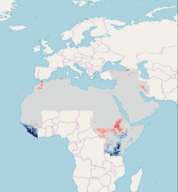
RICCAR, MENA Region - Q - Change in Annual Runoff (VIC RHM Ensemble for near-,mid-,end-century) This raster dataset provides a representation of the change in Annual Runoff in the Middle East and North Africa Region. Bias-corrected Regional Climate Models (RCM) results serve as inputs for the generation of the Regional Hydrological Model (RHM) ensemble that uses the open-source hydrological model VIC (Variable Infiltration Capacity). The RHM is applied to assess hydrological change using future climate projections and can accommodate large datasets spanning timescales exceeding 100 years. The RHM ensemble adopts the time periods used by the Intergovernmental Panel for Climate Change (IPCC) and other regional climate modelling experiments. It runs climate simulations based on three future time periods that are compared with a historical reference period. Available at 0,25 degree (approx. 28km) pixel resolution, for future time periods; Near, Mid and End-century, the raster grids are generated for moderate and high representative concentration pathways (RCPs), climate change scenarios developed by the IPCC for informing global and regional climate modelling work (RCP4.5 and RCP8.5). The adopted time periods are: Near-Century (2016-2035); Mid-Century (2046-2065); End-Century (2081-2100).