 FAO Map Catalog
Forest cover
Type of resources
Available actions
Topics
Keywords
Contact for the resource
Provided by
Years
Representation types
Update frequencies
status
-
Congo forest cover GAF 2000
-
-
-
Congo forest cover GAF 2010
-
Congo forest cover GAF 1990
-
Congo forest change GAF 2000
-
Congo forest change GAF 2010
-
-
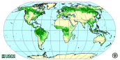
The forest cover map is the first comprehensive worldwide view of forests, using a consistent methodology and standard data. The map has a resolution of 1 km and is based on 1992-93 and 1995-96 AVHRR data. Four broad land cover categories are presented following FAO standard classification: closed forest, open/fragmented forest, other wooded land and other land. Due to the coarse source data, the map cannot be used to obtain reliable country forest cover statistics. The final map has been drafted through validation with information/maps based on higher resolution data, e.g. Landsat TM or SPOT images. An accuracy assessment will be carried out in year 2000 to determine the classification accuracy.