 FAO Map Catalog
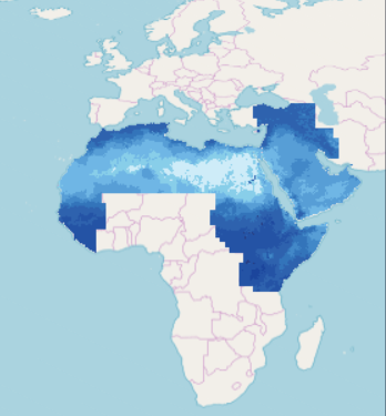
Evapotranspiration
Type of resources
Available actions
Topics
Keywords
Contact for the resource
Provided by
Years
Formats
Representation types
Update frequencies
status
-
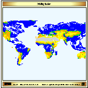
Aridity index (P/Pet) derived from IDRISI file with continuous data, reclassified into 5 classes (+ water bodies). The IDRISI file was received by IIASA on February 2003.
-
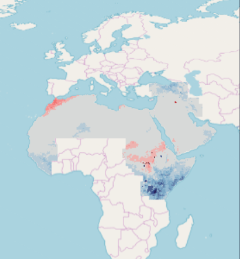
This raster dataset provides a representation of the change in Annual Evapotranspiration in the Middle East and North Africa Region. Bias-corrected Regional Climate Models (RCM) results serve as inputs for the generation of the Regional Hydrological Model (RHM) ensemble using open-source hydrological model HYPE (Hydrological Predictions for the Environment). The RHM is applied to assess hydrological change using future climate projections and can accommodate large datasets spanning timescales exceeding 100 years. The RHM ensemble adopts the time periods used by the Intergovernmental Panel for Climate Change (IPCC) and other regional climate modelling experiments. It runs climate simulations based on three future time periods that are compared with a historical reference period. Available at 0,19 degree (approx. 21km) pixel resolution, for future time periods; Near, Mid and End-century, the raster grids are generated for moderate and high representative concentration pathways (RCPs), climate change scenarios developed by the IPCC for informing global and regional climate modelling work (RCP4.5 and RCP8.5). The adopted time periods are: Near-Century (2016-2035); Mid-Century (2046-2065); End-Century (2081-2100).
-
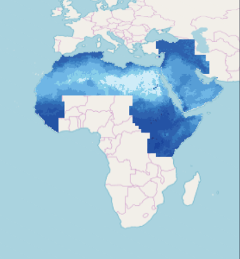
This raster dataset provides a representation of the Annual Evapotranspiration in the Middle East and North Africa Region, for the reference period 1986-2005. Bias-corrected Regional Climate Models (RCM) results serve as inputs for the generation of the Regional Hydrological Model (RHM) ensemble using the open-source hydrological model VIC (Variable Infiltration Capacity). The RHM is applied to assess hydrological change using future climate projections and can accommodate large datasets spanning timescales exceeding 100 years. The RHM ensemble adopts the time periods used by the Intergovernmental Panel for Climate Change (IPCC) and other regional climate modelling experiments. It runs climate simulations based on three future time periods that are compared with a historical reference period. Available for 1986-2005 reference period, the 0,25 degree (approx. 28km) pixel resolution raster grids are generated for Moderate and High representative concentration pathways (RCPs), climate change scenarios developed by the IPCC for informing global and regional climate modelling work: RCP4.5 and RCP8.5.
-

This raster dataset provides a representation of the change in monthly Evapotranspiration in the Middle East and North Africa Region. Bias-corrected Regional Climate Models (RCM) results serve as inputs for the generation of the Regional Hydrological Model (RHM) ensemble using open-source hydrological model VIC (Variable Infiltration Capacity). The RHM is applied to assess hydrological change using future climate projections and can accommodate large datasets spanning timescales exceeding 100 years. The RHM ensemble adopts the time periods used by the Intergovernmental Panel for Climate Change (IPCC) and other regional climate modelling experiments. It runs climate simulations based on three future time periods that are compared with a historical reference period. Available at 0,25 degree (approx. 28km) pixel resolution, for future time periods; Near, Mid and End-century, the raster grids are generated for moderate and high representative concentration pathways (RCPs), climate change scenarios developed by the IPCC for informing global and regional climate modelling work (RCP4.5 and RCP8.5). The adopted time periods are: Near-Century (2016-2035); Mid-Century (2046-2065); End-Century (2081-2100).
-
This raster dataset provides a representation of the change in Annual Evapotranspiration in the Middle East and North Africa Region. Bias-corrected Regional Climate Models (RCM) results serve as inputs for the generation of the Regional Hydrological Model (RHM) ensemble that uses open-source hydrological model VIC (Variable Infiltration Capacity). The RHM is applied to assess hydrological change using future climate projections and can accommodate large datasets spanning timescales exceeding 100 years. The RHM ensemble adopts the time periods used by the Intergovernmental Panel for Climate Change (IPCC) and other regional climate modelling experiments. It runs climate simulations based on three future time periods that are compared with a historical reference period. Available at 0,25 degree (approx. 28km) pixel resolution, for future time periods; Near, Mid and End-century, the raster grids are generated for moderate and high representative concentration pathways (RCPs), climate change scenarios developed by the IPCC for informing global and regional climate modelling work (RCP4.5 and RCP8.5). The adopted time periods are: Near-Century (2016-2035); Mid-Century (2046-2065); End-Century (2081-2100).
-
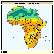
Monthly potential evapotranspiration values according to Penman-Monteith method for Africa. Data obtained from the International Institute for Applied Systems Analysis (IIASA).
-

This raster dataset provides a representation of the Annual Evapotranspiration in the Middle East and North Africa Region, for the reference period 1986-2005. Bias-corrected Regional Climate Models (RCM) results serve as inputs for the generation of the Regional Hydrological Model (RHM) ensemble using the open-source hydrological model HYPE (Hydrological Predictions for the Environment). The RHM is applied to assess hydrological change using future climate projections and can accommodate large datasets spanning timescales exceeding 100 years. The RHM ensemble adopts the time periods used by the Intergovernmental Panel for Climate Change (IPCC) and other regional climate modelling experiments. It runs climate simulations based on three future time periods that are compared with a historical reference period. Available for 1986-2005 reference period, the 0,19 degree (approx. 21km) pixel resolution raster grids are generated for Moderate and High representative concentration pathways (RCPs), climate change scenarios developed by the IPCC for informing global and regional climate modelling work: RCP4.5 and RCP8.5.
-
This raster dataset provides a representation of the change in Monthly Evapotranspiration in the Middle East and North Africa Region. Bias-corrected Regional Climate Models (RCM) results serve as inputs for the generation of the Regional Hydrological Model (RHM) ensemble using the open-source hydrological model HYPE (Hydrological Predictions for the Environment). The RHM is applied to assess hydrological change using future climate projections and can accommodate large datasets spanning timescales exceeding 100 years. The RHM ensemble adopts the time periods used by the Intergovernmental Panel for Climate Change (IPCC) and other regional climate modelling experiments. It runs climate simulations based on three future time periods that are compared with a historical reference period. Available at 0,19 degree (approx. 21km) pixel resolution, for future time periods; Near, Mid and End-century, the raster grids are generated for moderate and high representative concentration pathways (RCPs), climate change scenarios developed by the IPCC for informing global and regional climate modelling work (RCP4.5 and RCP8.5). The adopted time periods are: Near-Century (2016-2035); Mid-Century (2046-2065); End-Century (2081-2100).
-
This raster dataset provides a representation of the Monthly Evapotranspiration in the Middle East and North Africa Region, for the reference period 1986-2005. Bias-corrected Regional Climate Models (RCM) results serve as inputs for the generation of the Regional Hydrological Model (RHM) ensemble using the open-source hydrological model HYPE (Hydrological Predictions for the Environment). The RHM is applied to assess hydrological change using future climate projections and can accommodate large datasets spanning timescales exceeding 100 years. The RHM ensemble adopts the time periods used by the Intergovernmental Panel for Climate Change (IPCC) and other regional climate modelling experiments. It runs climate simulations based on three future time periods that are compared with a historical reference period. Available for 1986-2005 reference period, the 0,19 degree (approx. 21km) pixel resolution raster grids are generated for Moderate and High representative concentration pathways (RCPs), climate change scenarios developed by the IPCC for informing global and regional climate modelling work: RCP4.5 and RCP8.5.
-

This raster dataset provides a representation of the Monthly Evapotranspiration in the Middle East and North Africa Region, for the reference period 1986-2005. Bias-corrected Regional Climate Models (RCM) results serve as inputs for the generation of the Regional Hydrological Model (RHM) ensemble using the open-source hydrological model VIC (Variable Infiltration Capacity). The RHM is applied to assess hydrological change using future climate projections and can accommodate large datasets spanning timescales exceeding 100 years. The RHM ensemble adopts the time periods used by the Intergovernmental Panel for Climate Change (IPCC) and other regional climate modelling experiments. It runs climate simulations based on three future time periods that are compared with a historical reference period. Available for 1986-2005 reference period, the 0,25 degree (approx. 28km) pixel resolution raster grids are generated for Moderate and High representative concentration pathways (RCPs), climate change scenarios developed by the IPCC for informing global and regional climate modelling work: RCP4.5 and RCP8.5.