 FAO Map Catalog
CIFA Technical Paper 27
Type of resources
Available actions
Topics
Keywords
Contact for the resource
Provided by
Representation types
Update frequencies
status
-
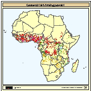
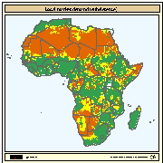
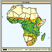
Areas with potential for commercial fish farming under three temperature regimes providing for one crop/year (1C) with fair to good growth (FGG), two crops/year with fair growth (FG) and with good growth (GG) in combination with four land-quality factors important for fish farming development and operation; water availability, engineering capability, and economic considerations ranging from all suitable to one suitable and two optimum (S-NO), or all optimum (all 0).
-
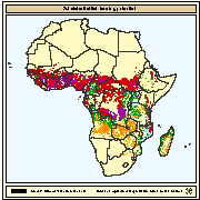
Areas with potential for subsistence fish farming under three temperature regimes providing for one crop/year (1C) with fair to good growth (FGG), two crops/year with fair growth (FG) and with good growth (GG) in combination with four land-quality factors important for fish farming development and operation; water availability, engineering capability, and economic considerations ranging from all suitable to one suitable and two optimum (S-NO), or all optimum (all 0).
-

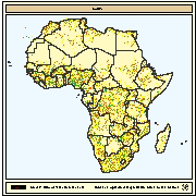
Soil texture interpreted in terms of suitability for pond construction. Soil texture data was obtained from the FAO-UNESCO Soil Map of Africa at 1:5 million scale. This dataset includes three soil texture classes: coarse, medium and fine and these are given for the dominant soils of each association and refer only to the upper 30cm.
-
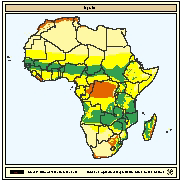
Population density (inhabitants/km2) represented in terms of local market demand for fish farming at the commercial level. Population density as inhabitants/km2 for the year 1988 was obtained from UNEP/GRID Nairobi.
-
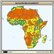
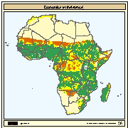
Engineering capability for pond construction obtained by combining soil texture and slope. Soil texture was interpreted in terms of suitability for pond construction. Soil texture data was obtained from the FAO-UNESCO Soil Map of Africa at 1:5 million scale. This dataset includes three soil texture classes: coarse, medium and fine and these are given for the dominant soils of each association and refer only to the upper 30cm. Slope was interpreted in terms of suitability of topography for pond construction. Slope data was also obtained from the FAO-UNESCO Soil Map of Africa at 1:5 million scale. This dataset includes three slopes classes which reflect the topography in which the soil association occurs.
-
Population density (inhabitants/km2) interpreted in terms of local market demand for fish farmed at the subsistence level. Population density as inhabitants/km2 for the year 1988 was obtained from UNEP/GRID Nairobi.
-
Availability of road infrastructure for the development of commercial fish farming interpreted as density of paved and motorable. The density of paved and motorable roads was used as a surrogate for the general level of infrastructure. It was reasoned that were there are main, all weather roads, there are possibilities to transport inputs and supplies to fish farms and to send products to markets than in areas without such road infrastructure. It was also reasoned that with that where all-weather roads exist, the probability of other kinds of infrastructure in close proximity, such as electricity and communication, is enhanced. Roads data was derived from the US Defense Mapping Agency (DMA) Topographic Maps in Africa and from the DMA Global Navigation and Planning Charts of Africa.
-
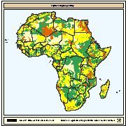
Productivity and variety of crops interpreted as availability of agricultural by products as inputs for fish farming. The objective of this map is to indicate the locations, availability and variety of agricultural by-products that could be used as inputs for fish farming. These can be related to agronomic suitability as measured by the length of growing period (LGP). Agro-ecological zones for 11 crops were defined for Africa by FAO (1978). LGP was calculated from data collected from 730 stations and plotted at 30-day intervals at 1:5 million scale.
-
Economic considerations for subsistence fish farming obtained by combining local market demand with availability of agricultural by-products as inputs. Population density (inhabitants/km2) was used to represent local market demand for fish farming at the commercial level. Productivity and variety of crops were interpreted as availability of agricultural by products as inputs for fish farming. Population density as inhabitants/km2 for the year 1988 was obtained from UNEP/GRID Nairobi. Agro-ecological zones for 11 crops were defined for Africa by FAO (1978). LGP was calculated from data collected from 730 stations and plotted at 30-day intervals at 1:5 million scale.
-
Spatial distribution of water availability for fish ponds. Map derived from the combined suitability of annual rainfall with density of perennial streams and rivers. Annual rainfall interpreted as rainfall runoff to fill fishponds. Mean annual precipitation data for Africa were obtained from UNEP/GRID in Nairobi and was developed for the Global Assessment of Soil Degradation (GLASOD) using data from 1951-1980. A digital map of perennial streams and rivers was generated by ESRI (1984).