 FAO Map Catalog
Biodiversity and Ecosystems
Type of resources
Available actions
Topics
Keywords
Provided by
Formats
Representation types
Update frequencies
status
-

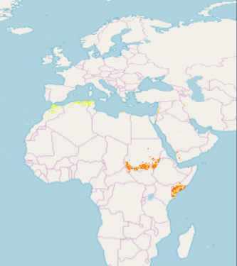
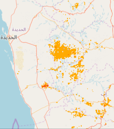
Part of the Integrated Vulnerability Assessment in the Arab Region, this 1km pixel resolution raster dataset provides a representation of future change in vulnerability hotspots for the Biodiversity and Ecosystems sector, in the Middle East and North Africa Region. The raster grid was generated for Mid-Century (2046-2065) time period, for moderate emission scenario - representative concentration pathway (RCP4.5) - developed by the Intergovernmental Panel on Climate Change (IPCC). Pixel values were classified according to vulnerability level: class 10 the top 10%, class 20 top 20% and class 30 top 30%. Vulnerability is a concept used to express the complex interaction of climate change effects and the susceptibility of a system to its impacts. The integrated vulnerability assessment methodology is based on an understanding of vulnerability as a function of a system’s climate change exposure, sensitivity and adaptive capacity to cope with climate change effects, consistent with the approach put forward by the IPCC in its Fourth Assessment Report (AR4). It adopts the time periods generally used by the IPCC and other regional climate modelling experiments and runs climate simulations based on future time periods that are compared with a historical reference period.
-

Part of the Integrated Vulnerability Assessment in the Arab Region, this 1km pixel resolution raster dataset provides a representation of future change in vulnerability hotspots for the Biodiversity and Ecosystems: Area Covered by Wetlands sub-sector, in the Middle East and North Africa Region. The raster grid was generated for Mid-Century time period (2046-2065), for moderate emission scenario - representative concentration pathway (RCP4.5) - developed by the Intergovernmental Panel on Climate Change (IPCC). Pixel values were classified according to vulnerability level: class 10 the top 10%, class 20 top 20% and class 30 top 30%. Vulnerability is a concept used to express the complex interaction of climate change effects and the susceptibility of a system to its impacts. The integrated vulnerability assessment methodology is based on an understanding of vulnerability as a function of a system’s climate change exposure, sensitivity and adaptive capacity to cope with climate change effects, consistent with the approach put forward by the IPCC in its Fourth Assessment Report (AR4). It adopts the time periods generally used by the IPCC and other regional climate modelling experiments and runs climate simulations based on future time periods that are compared with a historical reference period.
-

Part of the Integrated Vulnerability Assessment in the Arab Region, this 1km pixel resolution raster dataset provides a representation of future change in vulnerability hotspots for the Biodiversity and Ecosystems sector, in the Middle East and North Africa Region. The raster grid was generated for End-Century (2081-2100) time period, for high emission scenario - representative concentration pathway (RCP8.5) - developed by the Intergovernmental Panel on Climate Change (IPCC). Pixel values were classified according to vulnerability level: class 10 the top 10%, class 20 top 20% and class 30 top 30%. Vulnerability is a concept used to express the complex interaction of climate change effects and the susceptibility of a system to its impacts. The integrated vulnerability assessment methodology is based on an understanding of vulnerability as a function of a system’s climate change exposure, sensitivity and adaptive capacity to cope with climate change effects, consistent with the approach put forward by the IPCC in its Fourth Assessment Report (AR4). It adopts the time periods generally used by the IPCC and other regional climate modelling experiments and runs climate simulations based on future time periods that are compared with a historical reference period.
-

Part of the Integrated Vulnerability Assessment in the Arab Region, this 1km pixel resolution raster dataset provides a representation of future change in vulnerability hotspots for the Biodiversity and Ecosystems:Area Covered by Forests sub-sector, in the Middle East and North Africa Region. The raster grid was generated for End-Century time period (2081-2100), for moderate emission scenario - representative concentration pathway (RCP4.5) - developed by the Intergovernmental Panel on Climate Change (IPCC). Pixel values were classified according to vulnerability level: class 10 the top 10%, class 20 top 20% and class 30 top 30%. Vulnerability is a concept used to express the complex interaction of climate change effects and the susceptibility of a system to its impacts. The integrated vulnerability assessment methodology is based on an understanding of vulnerability as a function of a system’s climate change exposure, sensitivity and adaptive capacity to cope with climate change effects, consistent with the approach put forward by the IPCC in its Fourth Assessment Report (AR4). It adopts the time periods generally used by the IPCC and other regional climate modelling experiments and runs climate simulations based on future time periods that are compared with a historical reference period.
-
Part of the Integrated Vulnerability Assessment in the Arab Region, this 1km pixel resolution raster dataset provides a representation of future change in vulnerability for Biodiversity and Ecosystems sector, in the Middle East and North Africa Region. The Raster grid was generated for moderate representative concentration pathway (RCP4.5) emission scenario developed by the Intergovernmental Panel on Climate Change (IPCC) for time period End-Century (2081-2100). Pixel values are classified according to level of vulnerability, from low 1 to high 10. Vulnerability is a concept used to express the complex interaction of climate change effects and the susceptibility of a system to its impacts. The integrated vulnerability assessment methodology is based on an understanding of vulnerability as a function of a system’s climate change exposure, sensitivity and adaptive capacity to cope with climate change effects, consistent with the approach put forward by the IPCC in its Fourth Assessment Report (AR4). It adopts the time periods generally used by the IPCC and other regional climate modelling experiments, and runs climate simulations based on future time periods that are compared with a historical reference period.
-

Part of the Integrated Vulnerability Assessment in the Arab Region, this 1km pixel resolution raster dataset provides a representation of future change in vulnerability hotspots for the Biodiversity and Ecosystems:Area Covered by Forests sub-sector, in the Middle East and North Africa Region. The raster grid was generated for End-Century time period (2081-2100), for high emission scenario - representative concentration pathway (RCP8.5) - developed by the Intergovernmental Panel on Climate Change (IPCC). Pixel values were classified according to vulnerability level: class 10 the top 10%, class 20 top 20% and class 30 top 30%. Vulnerability is a concept used to express the complex interaction of climate change effects and the susceptibility of a system to its impacts. The integrated vulnerability assessment methodology is based on an understanding of vulnerability as a function of a system’s climate change exposure, sensitivity and adaptive capacity to cope with climate change effects, consistent with the approach put forward by the IPCC in its Fourth Assessment Report (AR4). It adopts the time periods generally used by the IPCC and other regional climate modelling experiments and runs climate simulations based on future time periods that are compared with a historical reference period.
-

Part of the Integrated Vulnerability Assessment in the Arab Region, this 1km pixel resolution raster dataset provides a representation of future change in vulnerability hotspots for the Biodiversity and Ecosystems:Area Covered by Wetlands sub-sector, in the Middle East and North Africa Region. The raster grid was generated for End-Century time period( 2081-2100), for moderate emission scenario - representative concentration pathway (RCP4.5) - developed by the Intergovernmental Panel on Climate Change (IPCC). Pixel values were classified according to vulnerability level: class 10 the top 10%, class 20 top 20% and class 30 top 30%. Vulnerability is a concept used to express the complex interaction of climate change effects and the susceptibility of a system to its impacts. The integrated vulnerability assessment methodology is based on an understanding of vulnerability as a function of a system’s climate change exposure, sensitivity and adaptive capacity to cope with climate change effects, consistent with the approach put forward by the IPCC in its Fourth Assessment Report (AR4). It adopts the time periods generally used by the IPCC and other regional climate modelling experiments and runs climate simulations based on future time periods that are compared with a historical reference period.
-

Part of the Integrated Vulnerability Assessment in the Arab Region, this 1km pixel resolution raster dataset provides a representation of future change in vulnerability for Biodiversity and Ecosystems: Area Covered by Wetlands sub-sector, in the Middle East and North Africa Region. The Raster grid was generated for high representative concentration pathway (RCP8.5) emission scenario developed by the Intergovernmental Panel on Climate Change (IPCC), for time period End-Century (2081-2100). Pixel values are classified according to level of vulnerability, from low 1 to high 10. Vulnerability is a concept used to express the complex interaction of climate change effects and the susceptibility of a system to its impacts. The integrated vulnerability assessment methodology is based on an understanding of vulnerability as a function of a system’s climate change exposure, sensitivity and adaptive capacity to cope with climate change effects, consistent with the approach put forward by the IPCC in its Fourth Assessment Report (AR4). It adopts the time periods generally used by the IPCC and other regional climate modelling experiments, and runs climate simulations based on future time periods that are compared with a historical reference period.
-
Part of the Integrated Vulnerability Assessment in the Arab Region, this 1km pixel resolution raster dataset provides a representation of future change in vulnerability hotspots for the Biodiversity and Ecosystems:Area Covered by Wetlands sub-sector, in the Middle East and North Africa Region. The raster grid was generated for Mid-Century time period (2046-2065), for high emission scenario - representative concentration pathway (RCP8.5) - developed by the Intergovernmental Panel on Climate Change (IPCC). Pixel values were classified according to vulnerability level: class 10 the top 10%, class 20 top 20% and class 30 top 30%. Vulnerability is a concept used to express the complex interaction of climate change effects and the susceptibility of a system to its impacts. The integrated vulnerability assessment methodology is based on an understanding of vulnerability as a function of a system’s climate change exposure, sensitivity and adaptive capacity to cope with climate change effects, consistent with the approach put forward by the IPCC in its Fourth Assessment Report (AR4). It adopts the time periods generally used by the IPCC and other regional climate modelling experiments and runs climate simulations based on future time periods that are compared with a historical reference period.
-
Part of the Integrated Vulnerability Assessment in the Arab Region, this 1km pixel resolution raster dataset provides a representation of future change in vulnerability hotspots for the Biodiversity and Ecosystems sector, in the Middle East and North Africa Region. The raster grid was generated for End-Century (2081-2100) time period, for moderate emission scenario - representative concentration pathway (RCP4.5) - developed by the Intergovernmental Panel on Climate Change (IPCC). Pixel values were classified according to vulnerability level: class 10 the top 10%, class 20 top 20% and class 30 top 30%. Vulnerability is a concept used to express the complex interaction of climate change effects and the susceptibility of a system to its impacts. The integrated vulnerability assessment methodology is based on an understanding of vulnerability as a function of a system’s climate change exposure, sensitivity and adaptive capacity to cope with climate change effects, consistent with the approach put forward by the IPCC in its Fourth Assessment Report (AR4). It adopts the time periods generally used by the IPCC and other regional climate modelling experiments and runs climate simulations based on future time periods that are compared with a historical reference period.